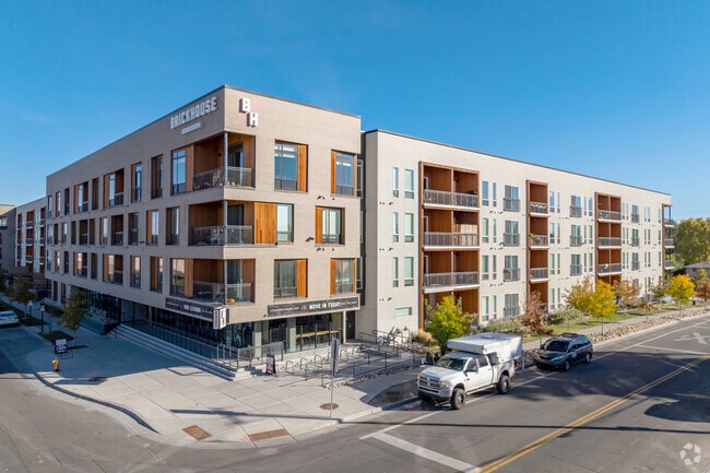
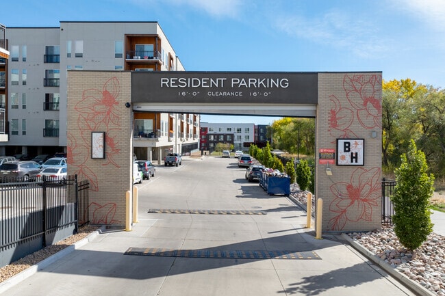
Property Record
6300 W 13Th Ave, Lakewood, CO 80214

NEARBY LISTINGS FOR SALE OR LEASE
-
-
-
No Photo
-
-
-
-
-
-
-
-
-
-
-
-
-
-
-
-
-
-
View all Lakewood listings for sale on LoopNet.com
Property Detail
6300 W 13Th Ave
Denver-Aurora-Lakewood, CO
Lakewood Blk 11 & 14 Lot Line Adj No 1
49-012-12-032
SECTION 01 TOWNSHIP 04 RANGE 69 SUBDIVISIONCD 443237 SUBDIVISIONNAME LAKEWOOD BLK 11 & 14 LOT LINE ADJ NO 1 LOT 0049 SIZE: 160478 VALUE: 3.684
Multifamilydwelling
Jefferson
AE
Colorado
08059C0302G
49
2023
3.68 AC
2024
Molholm Two Creeks
011552
Denver
276,895 SF
DEMOGRAPHICS near 6300 W 13Th Ave
1 Mile
3 Mile
5 Mile
2024 Total Population
20,072
159,887
452,805
2029 Population
20,224
160,671
455,935
Pop Growth 2024-2029
+ 0.76%
+ 0.49%
+ 0.69%
Average Age
38
38
39
2024 Total Households
9,008
68,667
208,157
HH Growth 2024-2029
+ 0.53%
+ 0.52%
+ 0.85%
Median Household Inc
$50,639
$70,362
$77,282
Avg Household Size
2.10
2.20
2.10
2024 Avg HH Vehicles
1.00
2.00
2.00
Median Home Value
$487,831
$520,910
$512,476
Median Year Built
1971
1964
1970
Nearby Places
Map Layers
Map Styles
 Street
 Aerial
- Restaurants
- Banks
- Shops
- Fitness
- Groceries
PUBLIC TRANSPORTATION
TRANSIT/SUBWAY
Lamar (W Line - Denver Regional Transportation District Light Rail (TheRide))
DRIVE
WALK
Distance
Lamar (W Line - Denver Regional Transportation District Light Rail (TheRide))
0 min
2 min
0.1 mi
Lakewood/Wadsworth (W Line - Denver Regional Transportation District Light Rail (TheRide))
DRIVE
WALK
Distance
Lakewood/Wadsworth (W Line - Denver Regional Transportation District Light Rail (TheRide))
2 min
17 min
0.8 mi
Sheridan (W Line - Denver Regional Transportation District Light Rail (TheRide))
DRIVE
WALK
Distance
Sheridan (W Line - Denver Regional Transportation District Light Rail (TheRide))
2 min
16 min
0.9 mi
COMMUTER RAIL
Union Station: Lodo-Coors Field-16Th Street Mall (C Line - Denver Regional Transportation District Light Rail (TheRide), E Line - Denver Regional Transportation District Light Rail (TheRide), W Line - Denver Regional Transportation District Light Rail (TheRide))
DRIVE
WALK
Distance
Union Station: Lodo-Coors Field-16Th Street Mall (C Line - Denver Regional Transportation District Light Rail (TheRide), E Line - Denver Regional Transportation District Light Rail (TheRide), W Line - Denver Regional Transportation District Light Rail (TheRide))
11 min
4.6 mi
Denver (California Zephyr - Amtrak)
DRIVE
WALK
Distance
Denver (California Zephyr - Amtrak)
12 min
4.8 mi
AIRPORT
Denver International
DRIVE
WALK
Distance
Denver International
41 min
29.7 mi
Freight Ports
Tulsa Port Of Catoosa
DRIVE
WALK
Distance
Tulsa Port Of Catoosa
739 min
715.2 mi
Nearby Properties
Address
Land Use
TOTAL SIZE
Lot Size
Zoning
Address
Land Use
TOTAL SIZE
Lot Size
Zoning
1,721,086 SF
21.34 AC
C-MU-30
Address
Land Use
TOTAL SIZE
Lot Size
Zoning
424,862 SF
32.28 AC
G-MU-3
Address
Land Use
TOTAL SIZE
Lot Size
Zoning
33.40 AC
C-MU-30
Address
Land Use
TOTAL SIZE
Lot Size
Zoning
333,925 SF
3.34 AC
C-MX-5
Address
Land Use
TOTAL SIZE
Lot Size
Zoning
8,295 SF
2.57 AC
C-RX
Address
Land Use
TOTAL SIZE
Lot Size
Zoning
827,707 SF
19 AC
C-MU-30
Address
Land Use
TOTAL SIZE
Lot Size
Zoning
107,351 SF
5.67 AC
C-MX-5
Address
Land Use
TOTAL SIZE
Lot Size
Zoning
111,673 SF
29.06 AC
Address
Land Use
TOTAL SIZE
Lot Size
Zoning
232,678 SF
27.50 AC
Address
Land Use
TOTAL SIZE
Lot Size
Zoning
132,874 SF
6.53 AC
G-MU-3
Address
Land Use
TOTAL SIZE
Lot Size
Zoning
175,000 SF
2.99 AC
C-MX
Address
Land Use
TOTAL SIZE
Lot Size
Zoning
233,688 SF
22.37 AC
Address
Land Use
TOTAL SIZE
Lot Size
Zoning
325,844 SF
4.08 AC
C-MX-12
Address
Land Use
TOTAL SIZE
Lot Size
Zoning
199,685 SF
27.73 AC
Address
Land Use
TOTAL SIZE
Lot Size
Zoning
392,996 SF
7.39 AC
C-MX-12
Address
Land Use
TOTAL SIZE
Lot Size
Zoning
187,095 SF
23.42 AC
Address
Land Use
TOTAL SIZE
Lot Size
Zoning
81,896 SF
0.61 AC
C-MX-5
Address
Land Use
TOTAL SIZE
Lot Size
Zoning
247,459 SF
2.31 AC
C-MX-8
Address
Land Use
TOTAL SIZE
Lot Size
Zoning
188,297 SF
2.11 AC
R-MU-30
Address
Land Use
TOTAL SIZE
Lot Size
Zoning
202,867 SF
2.28 AC
C-MX
Address
Land Use
TOTAL SIZE
Lot Size
Zoning
238,452 SF
8.03 AC
Address
Land Use
TOTAL SIZE
Lot Size
Zoning
411,402 SF
6.34 AC
C-RX
Address
Land Use
TOTAL SIZE
Lot Size
Zoning
197,266 SF
0.81 AC
C-MX-12
Address
Land Use
TOTAL SIZE
Lot Size
Zoning
339,907 SF
11.18 AC
I-A
Address
Land Use
TOTAL SIZE
Lot Size
Zoning
310,267 SF
1.69 AC
C-MX
Address
Land Use
TOTAL SIZE
Lot Size
Zoning
212,995 SF
3.20 AC
R-3
Address
Land Use
TOTAL SIZE
Lot Size
Zoning
211,800 SF
1.65 AC
C-MX-12
Address
Land Use
TOTAL SIZE
Lot Size
Zoning
373,294 SF
8.57 AC
C-MU-30
Address
Land Use
TOTAL SIZE
Lot Size
Zoning
135,372 SF
11.66 AC
Address
Land Use
TOTAL SIZE
Lot Size
Zoning
167,420 SF
5.84 AC
The World's #1 Commercial Real Estate Marketplace
Connect with us
© 2025 CoStar Group
The information above has been obtained from sources believed reliable. While we do not doubt its accuracy we have not verified it and make no guarantee, warranty or representation about it. It is your responsibility to independently confirm its accuracy and completeness. Any projections, opinions, assumptions, or estimates used are for example only and do not represent the current or future performance of the property. The value of this transaction to you depends on tax and other factors which should be evaluated by your tax, financial, and legal advisors. You and your advisors should conduct a careful, independent investigation of the property to determine to your satisfaction the suitability of the property for your needs.