Property Record
6301 Alondra Blvd, Paramount, CA 90723
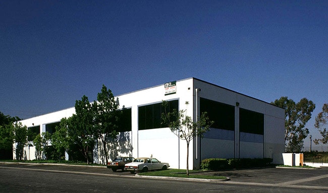


This Property Is For Sale
Property Detail
6301 Alondra Blvd
Los Angeles-Long Beach-Glendale, CA
PARCEL MAP AS PER BK 187 P 74-76 OF P M* (EX OF HIKING AND RIDING TRAIL) LOT 1
6239-015-013
Los Angeles
Warehouse
California
PAM2*
1
2024
1.12 AC
2025
Downey/Paramount
553802
Los Angeles
19,376 SF
NEARBY LISTINGS FOR SALE OR LEASE
DEMOGRAPHICS near 6301 Alondra Blvd
1 mile
3 mile
5 mile
2025 Total Population
36,365
299,732
728,423
2030 Population
35,536
294,449
716,793
Pop Growth 2025-2030
(2.28%)
(1.76%)
(1.60%)
Average Age
36
37
38
2025 Total Households
8,834
78,964
203,439
HH Growth 2025-2030
(2.68%)
(1.99%)
(1.81%)
Median Household Inc
$67,666
$73,641
$78,737
Avg Household Size
3.90
3.60
3.40
2025 Avg HH Vehicles
2.00
2.00
2.00
Median Home Value
$607,539
$654,897
$699,536
Median Year Built
1958
1958
1958
Nearby Places
Map Layers
Map Styles
 Street
 Aerial
Layers
 Traffic
 Biking
Places
Listings with unknown addresses are not visible on the map
- Restaurants
- Banks
- Shops
- Fitness
- Groceries
PUBLIC TRANSPORTATION
COMMUTER RAIL
Commerce (91 Line - Southern California Regional Rail Authority (Metrolink), Orange County Line - Southern California Regional Rail Authority (Metrolink))
Drive
Walk
Distance
Commerce (91 Line - Southern California Regional Rail Authority (Metrolink), Orange County Line - Southern California Regional Rail Authority (Metrolink))
16 min
8.9 mi
Norwalk/Santa Fe Springs (91 Line - Southern California Regional Rail Authority (Metrolink), Orange County Line - Southern California Regional Rail Authority (Metrolink))
Drive
Walk
Distance
Norwalk/Santa Fe Springs (91 Line - Southern California Regional Rail Authority (Metrolink), Orange County Line - Southern California Regional Rail Authority (Metrolink))
17 min
9.1 mi
AIRPORT
Long Beach (Daugherty Field)
Drive
Walk
Distance
Long Beach (Daugherty Field)
14 min
6.6 mi
Los Angeles International
Drive
Walk
Distance
Los Angeles International
24 min
16.8 mi
John Wayne/Orange County
Drive
Walk
Distance
John Wayne/Orange County
37 min
28.5 mi
Freight Ports
Port of Long Beach
Drive
Walk
Distance
Port of Long Beach
16 min
10.1 mi
Nearby Properties
Address
Land Use
TOTAL SIZE
Lot Size
Zoning
Address
Land Use
TOTAL SIZE
Lot Size
Zoning
587,291 SF
11.42 AC
LYHMD*
Address
Land Use
TOTAL SIZE
Lot Size
Zoning
18,791 SF
54.78 AC
LCM2
Address
Land Use
TOTAL SIZE
Lot Size
Zoning
313,224 SF
4.41 AC
SGM2*
Address
Land Use
TOTAL SIZE
Lot Size
Zoning
556,348 SF
26.38 AC
PAM2
Address
Land Use
TOTAL SIZE
Lot Size
Zoning
373,498 SF
5.20 AC
LBR4R
Address
Land Use
TOTAL SIZE
Lot Size
Zoning
395,436 SF
17.22 AC
LBMG
Address
Land Use
TOTAL SIZE
Lot Size
Zoning
169,400 SF
8.11 AC
COMH*
Address
Land Use
TOTAL SIZE
Lot Size
Zoning
37,867 SF
8.32 AC
COMH-B*
Address
Land Use
TOTAL SIZE
Lot Size
Zoning
130,977 SF
5.55 AC
LCM2*
Address
Land Use
TOTAL SIZE
Lot Size
Zoning
157,320 SF
7.18 AC
COMH*
Address
Land Use
TOTAL SIZE
Lot Size
Zoning
622,175 SF
14.25 AC
LCM11/2*
Address
Land Use
TOTAL SIZE
Lot Size
Zoning
292,696 SF
11.48 AC
LBR4
Address
Land Use
TOTAL SIZE
Lot Size
Zoning
132,404 SF
4.84 AC
LBIG
Address
Land Use
TOTAL SIZE
Lot Size
Zoning
233,030 SF
10.95 AC
LBR4
Address
Land Use
TOTAL SIZE
Lot Size
Zoning
108,564 SF
2.48 AC
LBR4N
Address
Land Use
TOTAL SIZE
Lot Size
Zoning
120,000 SF
LCM1
Address
Land Use
TOTAL SIZE
Lot Size
Zoning
70,080 SF
3.69 AC
LCM2*
Address
Land Use
TOTAL SIZE
Lot Size
Zoning
99,900 SF
4.10 AC
COMH*
Address
Land Use
TOTAL SIZE
Lot Size
Zoning
77,994 SF
3.59 AC
LCM 11/2
Address
Land Use
TOTAL SIZE
Lot Size
Zoning
96,849 SF
7.56 AC
LKC3YY
Address
Land Use
TOTAL SIZE
Lot Size
Zoning
91,500 SF
3.01 AC
LCM2*
Address
Land Use
TOTAL SIZE
Lot Size
Zoning
183,128 SF
10.77 AC
PAM2*
Address
Land Use
TOTAL SIZE
Lot Size
Zoning
26,262 SF
4.97 AC
LCM2*
Address
Land Use
TOTAL SIZE
Lot Size
Zoning
149,723 SF
9.90 AC
LBIG
Address
Land Use
TOTAL SIZE
Lot Size
Zoning
97,204 SF
4.10 AC
COMH*
Address
Land Use
TOTAL SIZE
Lot Size
Zoning
150,346 SF
13.13 AC
CORM*
Address
Land Use
TOTAL SIZE
Lot Size
Zoning
126,905 SF
7.87 AC
LBCHW
The World's #1 Commercial Real Estate Marketplace
Connect with us
© 2026 CoStar Group
The information above has been obtained from sources believed reliable. While we do not doubt its accuracy we have not verified it and make no guarantee, warranty or representation about it. It is your responsibility to independently confirm its accuracy and completeness. Any projections, opinions, assumptions, or estimates used are for example only and do not represent the current or future performance of the property. The value of this transaction to you depends on tax and other factors which should be evaluated by your tax, financial, and legal advisors. You and your advisors should conduct a careful, independent investigation of the property to determine to your satisfaction the suitability of the property for your needs.