Property Record
6302 Texaco Dr, Eau Claire, WI 54703
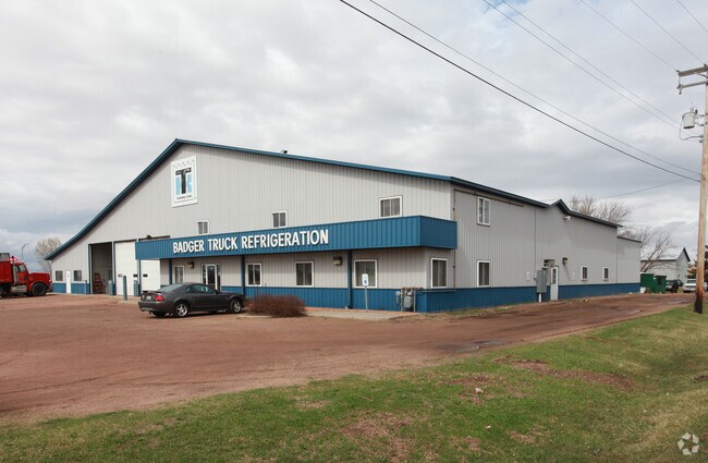

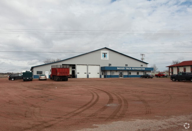
Property Detail
6302 Texaco Dr
Eau Claire, WI
LOT 1 CSM 2475 (VOL 13 P 273 #967047)
18022-2-271004-430-9005
Eau Claire
Commercialnec
Wisconsin
C3
1
B and X Area of moderate flood hazard, usually the area between the limits of the 100-year and 500-year floods.
6.98 AC
2025
Eau Claire/Menomonie
2025
Other Market Areas
001500
NEARBY LISTINGS FOR SALE OR LEASE
DEMOGRAPHICS near 6302 Texaco Dr
1 mile
3 mile
5 mile
2025 Total Population
1,044
4,432
25,951
2030 Population
1,100
4,650
26,724
Pop Growth 2025-2030
+ 5.36%
+ 4.92%
+ 2.98%
Average Age
39
40
39
2025 Total Households
394
1,699
10,773
HH Growth 2025-2030
+ 5.58%
+ 5.00%
+ 3.06%
Median Household Inc
$92,279
$92,249
$73,476
Avg Household Size
2.60
2.60
2.30
2025 Avg HH Vehicles
2.00
2.00
2.00
Median Home Value
$272,014
$276,281
$255,218
Median Year Built
2001
2000
1979
Nearby Places
Map Layers
Map Styles
 Street
 Aerial
Layers
 Traffic
 Biking
Places
Listings with unknown addresses are not visible on the map
- Restaurants
- Banks
- Shops
- Fitness
- Groceries
Nearby Properties
Address
Land Use
TOTAL SIZE
Lot Size
Zoning
Address
Land Use
TOTAL SIZE
Lot Size
Zoning
119.93 AC
Address
Land Use
TOTAL SIZE
Lot Size
Zoning
33.32 AC
I1
Address
Land Use
TOTAL SIZE
Lot Size
Zoning
61.27 AC
C2
Address
Land Use
TOTAL SIZE
Lot Size
Zoning
40.76 AC
I1P
Address
Land Use
TOTAL SIZE
Lot Size
Zoning
66.12 AC
I1
Address
Land Use
TOTAL SIZE
Lot Size
Zoning
169,740 SF
19.59 AC
C3P
Address
Land Use
TOTAL SIZE
Lot Size
Zoning
163,428 SF
30.30 AC
I1P
Address
Land Use
TOTAL SIZE
Lot Size
Zoning
Address
Land Use
TOTAL SIZE
Lot Size
Zoning
36.59 AC
I1
Address
Land Use
TOTAL SIZE
Lot Size
Zoning
207,960 SF
9.22 AC
I1P
Address
Land Use
TOTAL SIZE
Lot Size
Zoning
9.70 AC
C3
Address
Land Use
TOTAL SIZE
Lot Size
Zoning
10.68 AC
I1P
Address
Land Use
TOTAL SIZE
Lot Size
Zoning
14.28 AC
I1P
Address
Land Use
TOTAL SIZE
Lot Size
Zoning
38.99 AC
I1
Address
Land Use
TOTAL SIZE
Lot Size
Zoning
84.65 AC
Address
Land Use
TOTAL SIZE
Lot Size
Zoning
69,320 SF
5.98 AC
Address
Land Use
TOTAL SIZE
Lot Size
Zoning
50,980 SF
1.99 AC
R3P
Address
Land Use
TOTAL SIZE
Lot Size
Zoning
42.25 AC
I1
Address
Land Use
TOTAL SIZE
Lot Size
Zoning
22.53 AC
I1
Address
Land Use
TOTAL SIZE
Lot Size
Zoning
8.64 AC
I1
Address
Land Use
TOTAL SIZE
Lot Size
Zoning
64,850 SF
8.01 AC
I1P
Address
Land Use
TOTAL SIZE
Lot Size
Zoning
39.42 AC
Address
Land Use
TOTAL SIZE
Lot Size
Zoning
100,800 SF
10.25 AC
I1P
Address
Land Use
TOTAL SIZE
Lot Size
Zoning
13.74 AC
I1P
Address
Land Use
TOTAL SIZE
Lot Size
Zoning
42,544 SF
3.73 AC
C2P
Address
Land Use
TOTAL SIZE
Lot Size
Zoning
31.76 AC
Address
Land Use
TOTAL SIZE
Lot Size
Zoning
9.22 AC
Address
Land Use
TOTAL SIZE
Lot Size
Zoning
30.46 AC
I1
Address
Land Use
TOTAL SIZE
Lot Size
Zoning
96,270 SF
7.60 AC
Address
Land Use
TOTAL SIZE
Lot Size
Zoning
26,677 SF
2.60 AC
The World's #1 Commercial Real Estate Marketplace
Connect with us
© 2026 CoStar Group
The information above has been obtained from sources believed reliable. While we do not doubt its accuracy we have not verified it and make no guarantee, warranty or representation about it. It is your responsibility to independently confirm its accuracy and completeness. Any projections, opinions, assumptions, or estimates used are for example only and do not represent the current or future performance of the property. The value of this transaction to you depends on tax and other factors which should be evaluated by your tax, financial, and legal advisors. You and your advisors should conduct a careful, independent investigation of the property to determine to your satisfaction the suitability of the property for your needs.