Property Record
631 Indian Trail Lilburn Rd Nw, Lilburn, GA 30047

Save to a Folder
{{folder.Name}}
{{folder.ListingIds.length}} Properties
{{folder.ListingIds.length}} Property
Create a New Folder
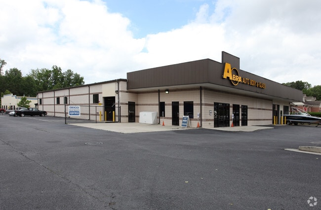
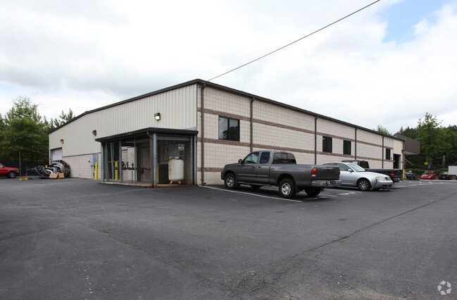
This Property Is For Sale
Property Detail
631 Indian Trail Lilburn Rd Nw
6-160-480
INDIAN TRAIL LILBURN RD
Autorepair
GWINNETT
CB
Georgia
B and X Area of moderate flood hazard, usually the area between the limits of the 100-year and 500-year floods.
160
2025
2.33 AC
2025
Norcross/Peachtree
050459
Atlanta
24,456 SF
Atlanta-Sandy Springs-Roswell, GA
NEARBY LISTINGS FOR SALE OR LEASE
DEMOGRAPHICS near 631 Indian Trail Lilburn Rd Nw
1 mile
3 mile
5 mile
2025 Total Population
12,920
96,137
265,697
2030 Population
13,403
99,475
275,252
Pop Growth 2025-2030
+ 3.74%
+ 3.47%
+ 3.60%
Average Age
35
36
37
2025 Total Households
3,839
30,911
90,125
HH Growth 2025-2030
+ 3.83%
+ 3.46%
+ 3.59%
Median Household Inc
$61,189
$63,840
$67,299
Avg Household Size
3.20
3.00
2.90
2025 Avg HH Vehicles
2.00
2.00
2.00
Median Home Value
$303,864
$336,932
$359,360
Median Year Built
1985
1987
1988
Nearby Places
Map Layers
Map Styles
 Street
 Aerial
Layers
 Traffic
 Biking
Places
Listings with unknown addresses are not visible on the map
- Restaurants
- Banks
- Shops
- Fitness
- Groceries
PUBLIC TRANSPORTATION
AIRPORT
Hartsfield - Jackson Atlanta International
Drive
Walk
Distance
Hartsfield - Jackson Atlanta International
45 min
31.8 mi
Nearby Properties
Address
Land Use
TOTAL SIZE
Lot Size
Zoning
Address
Land Use
TOTAL SIZE
Lot Size
Zoning
709,399 SF
59.34 AC
RM13
Address
Land Use
TOTAL SIZE
Lot Size
Zoning
338,670 SF
28.61 AC
RM
Address
Land Use
TOTAL SIZE
Lot Size
Zoning
464,756 SF
33.96 AC
RM13
Address
Land Use
TOTAL SIZE
Lot Size
Zoning
483,912 SF
43.10 AC
OI
Address
Land Use
TOTAL SIZE
Lot Size
Zoning
525,526 SF
80.61 AC
RA200
Address
Land Use
TOTAL SIZE
Lot Size
Zoning
470,856 SF
34.99 AC
RM13
Address
Land Use
TOTAL SIZE
Lot Size
Zoning
285,440 SF
24.68 AC
RM
Address
Land Use
TOTAL SIZE
Lot Size
Zoning
413,878 SF
29.13 AC
CB
Address
Land Use
TOTAL SIZE
Lot Size
Zoning
455,471 SF
48.23 AC
R75
Address
Land Use
TOTAL SIZE
Lot Size
Zoning
364,994 SF
34.06 AC
RM13
Address
Land Use
TOTAL SIZE
Lot Size
Zoning
257,050 SF
26.17 AC
RM13
Address
Land Use
TOTAL SIZE
Lot Size
Zoning
285,384 SF
21.32 AC
RM
Address
Land Use
TOTAL SIZE
Lot Size
Zoning
371,383 SF
29.56 AC
RM13
Address
Land Use
TOTAL SIZE
Lot Size
Zoning
287,502 SF
43.15 AC
R1
Address
Land Use
TOTAL SIZE
Lot Size
Zoning
367,517 SF
34.61 AC
RM13
Address
Land Use
TOTAL SIZE
Lot Size
Zoning
245,165 SF
16.66 AC
RA200
Address
Land Use
TOTAL SIZE
Lot Size
Zoning
283,958 SF
23.75 AC
RM13
Address
Land Use
TOTAL SIZE
Lot Size
Zoning
225,939 SF
19.79 AC
RM13
Address
Land Use
TOTAL SIZE
Lot Size
Zoning
290,652 SF
35.67 AC
RM8
Address
Land Use
TOTAL SIZE
Lot Size
Zoning
353,094 SF
23.33 AC
RM
Address
Land Use
TOTAL SIZE
Lot Size
Zoning
244,131 SF
32.59 AC
RM8
Address
Land Use
TOTAL SIZE
Lot Size
Zoning
239,816 SF
18.37 AC
RM13
Address
Land Use
TOTAL SIZE
Lot Size
Zoning
172,197 SF
18.03 AC
RM10
Address
Land Use
TOTAL SIZE
Lot Size
Zoning
188,118 SF
13.87 AC
RM13
Address
Land Use
TOTAL SIZE
Lot Size
Zoning
174,905 SF
35.72 AC
R1
Address
Land Use
TOTAL SIZE
Lot Size
Zoning
253,672 SF
15.07 AC
M1
Address
Land Use
TOTAL SIZE
Lot Size
Zoning
195,253 SF
21.87 AC
R100
Address
Land Use
TOTAL SIZE
Lot Size
Zoning
140,613 SF
21.45 AC
R75
Address
Land Use
TOTAL SIZE
Lot Size
Zoning
186,325 SF
17.24 AC
RM13
Address
Land Use
TOTAL SIZE
Lot Size
Zoning
156,635 SF
13.67 AC
RM
The World's #1 Commercial Real Estate Marketplace
Connect with us
© 2026 CoStar Group
The information above has been obtained from sources believed reliable. While we do not doubt its accuracy we have not verified it and make no guarantee, warranty or representation about it. It is your responsibility to independently confirm its accuracy and completeness. Any projections, opinions, assumptions, or estimates used are for example only and do not represent the current or future performance of the property. The value of this transaction to you depends on tax and other factors which should be evaluated by your tax, financial, and legal advisors. You and your advisors should conduct a careful, independent investigation of the property to determine to your satisfaction the suitability of the property for your needs.