Property Record
632 Metacom Ave, Warren, RI 02885

Save to a Folder
{{folder.Name}}
{{folder.ListingIds.length}} Properties
{{folder.ListingIds.length}} Property
Create a New Folder
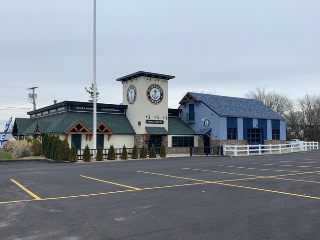
Property Detail
632 Metacom Ave
WARR-000013D-000000-000446
Bristol
Restaurantbuilding
Rhode Island
B
446
B and X Area of moderate flood hazard, usually the area between the limits of the 100-year and 500-year floods.
0.96 AC
2025
Bristol County
2025
Providence
030602
Providence-Warwick, RI-MA
8,297 SF
NEARBY LISTINGS FOR SALE OR LEASE
DEMOGRAPHICS near 632 Metacom Ave
1 mile
3 mile
5 mile
2025 Total Population
7,561
36,617
72,504
2030 Population
7,467
36,502
72,494
Pop Growth 2025-2030
(1.24%)
(0.31%)
(0.01%)
Average Age
46
45
43
2025 Total Households
3,273
15,028
28,796
HH Growth 2025-2030
(1.34%)
(0.45%)
(0.02%)
Median Household Inc
$80,946
$100,119
$104,611
Avg Household Size
2.20
2.40
2.40
2025 Avg HH Vehicles
2.00
2.00
2.00
Median Home Value
$449,908
$503,292
$495,261
Median Year Built
1965
1965
1961
Nearby Places
Map Layers
Map Styles
 Street
 Aerial
Layers
 Traffic
 Biking
Places
Listings with unknown addresses are not visible on the map
- Restaurants
- Banks
- Shops
- Fitness
- Groceries
PUBLIC TRANSPORTATION
AIRPORT
Rhode Island Tf Green International
Drive
Walk
Distance
Rhode Island Tf Green International
35 min
20.6 mi
Freight Ports
Port of New Bedford Harbor
Drive
Walk
Distance
Port of New Bedford Harbor
31 min
22.0 mi
SALE & LEASE HISTORY
LISTING DATE
SALE/LEASE

Nov 02, 2021
For Sale
Dec 26, 2017
For Sale
Aug 26, 2021
For Sale
Apr 23, 2018
For Lease
Nearby Properties
Address
Land Use
TOTAL SIZE
Lot Size
Zoning
Address
Land Use
TOTAL SIZE
Lot Size
Zoning
113,253 SF
85.69 AC
HPC
Address
Land Use
TOTAL SIZE
Lot Size
Zoning
367,305 SF
8.23 AC
WF
Address
Land Use
TOTAL SIZE
Lot Size
Zoning
159,363 SF
14.19 AC
R-10
Address
Land Use
TOTAL SIZE
Lot Size
Zoning
17,500 SF
5.92 AC
WF
Address
Land Use
TOTAL SIZE
Lot Size
Zoning
2.71 AC
B
Address
Land Use
TOTAL SIZE
Lot Size
Zoning
2,080 SF
11.01 AC
R-15
Address
Land Use
TOTAL SIZE
Lot Size
Zoning
18,236 SF
10.24 AC
LB
Address
Land Use
TOTAL SIZE
Lot Size
Zoning
140,460 SF
12.50 AC
R10
Address
Land Use
TOTAL SIZE
Lot Size
Zoning
4.39 AC
B
Address
Land Use
TOTAL SIZE
Lot Size
Zoning
1.97 AC
R10
Address
Land Use
TOTAL SIZE
Lot Size
Zoning
4.40 AC
B
Address
Land Use
TOTAL SIZE
Lot Size
Zoning
199,796 SF
9.11 AC
RB
Address
Land Use
TOTAL SIZE
Lot Size
Zoning
63,730 SF
12.97 AC
M
Address
Land Use
TOTAL SIZE
Lot Size
Zoning
31,338 SF
0.95 AC
GI
Address
Land Use
TOTAL SIZE
Lot Size
Zoning
2.88 AC
B
Address
Land Use
TOTAL SIZE
Lot Size
Zoning
19,144 SF
7.29 AC
R40
Address
Land Use
TOTAL SIZE
Lot Size
Zoning
39,150 SF
10.10 AC
C
Address
Land Use
TOTAL SIZE
Lot Size
Zoning
61,332 SF
6.43 AC
R-6
Address
Land Use
TOTAL SIZE
Lot Size
Zoning
80,232 SF
1.32 AC
M
Address
Land Use
TOTAL SIZE
Lot Size
Zoning
29,058 SF
21.97 AC
R40
Address
Land Use
TOTAL SIZE
Lot Size
Zoning
4.80 AC
GB
Address
Land Use
TOTAL SIZE
Lot Size
Zoning
19,799 SF
13.36 AC
GI
Address
Land Use
TOTAL SIZE
Lot Size
Zoning
4,398 SF
2.91 AC
R40
Address
Land Use
TOTAL SIZE
Lot Size
Zoning
120,540 SF
6.33 AC
M
Address
Land Use
TOTAL SIZE
Lot Size
Zoning
68,144 SF
7.74 AC
M
Address
Land Use
TOTAL SIZE
Lot Size
Zoning
64,850 SF
11.67 AC
CI
Address
Land Use
TOTAL SIZE
Lot Size
Zoning
15,120 SF
6.94 AC
M
Address
Land Use
TOTAL SIZE
Lot Size
Zoning
2 AC
R40
Address
Land Use
TOTAL SIZE
Lot Size
Zoning
61,743 SF
42.75 AC
R20
Address
Land Use
TOTAL SIZE
Lot Size
Zoning
3,476 SF
34.46 AC
RE
The World's #1 Commercial Real Estate Marketplace
Connect with us
© 2026 CoStar Group
The information above has been obtained from sources believed reliable. While we do not doubt its accuracy we have not verified it and make no guarantee, warranty or representation about it. It is your responsibility to independently confirm its accuracy and completeness. Any projections, opinions, assumptions, or estimates used are for example only and do not represent the current or future performance of the property. The value of this transaction to you depends on tax and other factors which should be evaluated by your tax, financial, and legal advisors. You and your advisors should conduct a careful, independent investigation of the property to determine to your satisfaction the suitability of the property for your needs.