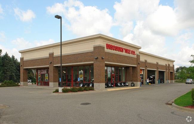
Property Record
633 Apollo Dr, Circle Pines, MN 55014

Save to a Folder
{{folder.Name}}
{{folder.ListingIds.length}} Properties
{{folder.ListingIds.length}} Property
Create a New Folder
Property Detail
633 Apollo Dr
Minneapolis-St. Paul-Bloomington, MN-WI
LOT 1 BLOCK 1 LINO LAKES MARKET PLACE, SUBJ TO EASEOF REC
08-31-22-43-0022
ANOKA
Commercialnec
Minnesota
B and X Area of moderate flood hazard, usually the area between the limits of the 100-year and 500-year floods.
1
2026
1.13 AC
2026
Rosedale
050233
Minneapolis/St Paul
10,684 SF
NEARBY LISTINGS FOR SALE OR LEASE
DEMOGRAPHICS near 633 Apollo Dr
1 mile
3 mile
5 mile
2025 Total Population
3,447
19,476
68,254
2030 Population
3,527
20,204
70,891
Pop Growth 2025-2030
+ 2.32%
+ 3.74%
+ 3.86%
Average Age
40
40
40
2025 Total Households
1,106
6,307
23,783
HH Growth 2025-2030
+ 2.62%
+ 3.85%
+ 3.87%
Median Household Inc
$114,415
$112,966
$121,396
Avg Household Size
2.80
2.80
2.80
2025 Avg HH Vehicles
2.00
2.00
2.00
Median Home Value
$369,380
$384,363
$420,536
Median Year Built
1993
1990
1996
Nearby Places
Map Layers
Map Styles
 Street
 Aerial
Layers
 Traffic
 Biking
Places
Listings with unknown addresses are not visible on the map
- Restaurants
- Banks
- Shops
- Fitness
- Groceries
PUBLIC TRANSPORTATION
AIRPORT
Minneapolis-St Paul International/Wold-Chamberlain
Drive
Walk
Distance
Minneapolis-St Paul International/Wold-Chamberlain
42 min
30.0 mi
Nearby Properties
Address
Land Use
TOTAL SIZE
Lot Size
Zoning
Address
Land Use
TOTAL SIZE
Lot Size
Zoning
226,201 SF
0.70 AC
Address
Land Use
TOTAL SIZE
Lot Size
Zoning
156,499 SF
0.80 AC
Address
Land Use
TOTAL SIZE
Lot Size
Zoning
Address
Land Use
TOTAL SIZE
Lot Size
Zoning
152,721 SF
Address
Land Use
TOTAL SIZE
Lot Size
Zoning
265,400 SF
0.13 AC
Address
Land Use
TOTAL SIZE
Lot Size
Zoning
74,366 SF
10 AC
Address
Land Use
TOTAL SIZE
Lot Size
Zoning
46,557 SF
0.90 AC
Address
Land Use
TOTAL SIZE
Lot Size
Zoning
223,763 SF
24.89 AC
Address
Land Use
TOTAL SIZE
Lot Size
Zoning
48,260 SF
10.38 AC
Address
Land Use
TOTAL SIZE
Lot Size
Zoning
180,712 SF
15.95 AC
Address
Land Use
TOTAL SIZE
Lot Size
Zoning
43,132 SF
37.89 AC
Address
Land Use
TOTAL SIZE
Lot Size
Zoning
52,981 SF
5.27 AC
Address
Land Use
TOTAL SIZE
Lot Size
Zoning
32,314 SF
0.40 AC
Address
Land Use
TOTAL SIZE
Lot Size
Zoning
243,028 SF
24.35 AC
Address
Land Use
TOTAL SIZE
Lot Size
Zoning
1 SF
0.24 AC
Address
Land Use
TOTAL SIZE
Lot Size
Zoning
109,470 SF
12.67 AC
Address
Land Use
TOTAL SIZE
Lot Size
Zoning
120,680 SF
0.11 AC
Address
Land Use
TOTAL SIZE
Lot Size
Zoning
79,827 SF
2.81 AC
Address
Land Use
TOTAL SIZE
Lot Size
Zoning
40,983 SF
Address
Land Use
TOTAL SIZE
Lot Size
Zoning
6,316 SF
28.25 AC
Address
Land Use
TOTAL SIZE
Lot Size
Zoning
67,688 SF
40 AC
Address
Land Use
TOTAL SIZE
Lot Size
Zoning
3,947 SF
40 AC
Address
Land Use
TOTAL SIZE
Lot Size
Zoning
881 SF
0.80 AC
Address
Land Use
TOTAL SIZE
Lot Size
Zoning
83,252 SF
7.75 AC
Address
Land Use
TOTAL SIZE
Lot Size
Zoning
75,440 SF
0.50 AC
Address
Land Use
TOTAL SIZE
Lot Size
Zoning
140,684 SF
3.65 AC
Address
Land Use
TOTAL SIZE
Lot Size
Zoning
51,042 SF
0.80 AC
Address
Land Use
TOTAL SIZE
Lot Size
Zoning
1,144 SF
39 AC
Address
Land Use
TOTAL SIZE
Lot Size
Zoning
83,351 SF
Address
Land Use
TOTAL SIZE
Lot Size
Zoning
3,000 SF
0.50 AC
The World's #1 Commercial Real Estate Marketplace
Connect with us
© 2026 CoStar Group
The information above has been obtained from sources believed reliable. While we do not doubt its accuracy we have not verified it and make no guarantee, warranty or representation about it. It is your responsibility to independently confirm its accuracy and completeness. Any projections, opinions, assumptions, or estimates used are for example only and do not represent the current or future performance of the property. The value of this transaction to you depends on tax and other factors which should be evaluated by your tax, financial, and legal advisors. You and your advisors should conduct a careful, independent investigation of the property to determine to your satisfaction the suitability of the property for your needs.