Property Record
6395 Sheridan Blvd, Arvada, CO 80003
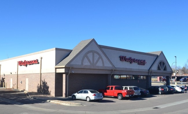
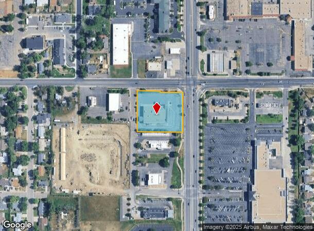
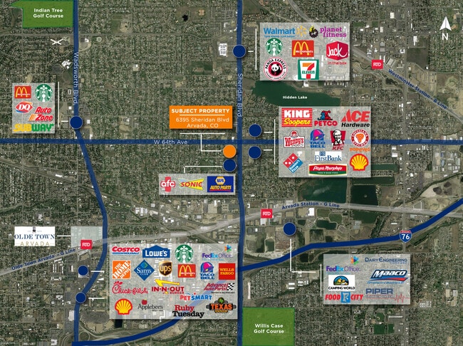

This Property Is For Sale
Current Lease Availabilities
NEARBY LISTINGS FOR SALE OR LEASE
Property Detail
6395 Sheridan Blvd
Denver-Aurora-Lakewood, CO
Ravinia Park
39-121-22-001
SECTION 12 TOWNSHIP 03 RANGE 69 QTR NE SUBDIVISIONCD 631210 SUBDIVISIONNAME RAVINIA PARK BLOCK LOT 0001 SIZE: 64970 TRACT VALUE: 1.492
Commercialnec
Jefferson
X
Colorado
08059C0216F
1
2023
1.49 AC
2024
Northwest
010213
Denver
13,429 SF
DEMOGRAPHICS near 6395 Sheridan Blvd
1 Mile
3 Mile
5 Mile
2024 Total Population
12,096
131,066
369,334
2029 Population
12,134
132,222
374,326
Pop Growth 2024-2029
+ 0.31%
+ 0.88%
+ 1.35%
Average Age
41
39
39
2024 Total Households
4,520
52,379
155,862
HH Growth 2024-2029
+ 0.27%
+ 0.70%
+ 1.26%
Median Household Inc
$81,026
$76,909
$82,027
Avg Household Size
2.60
2.40
2.30
2024 Avg HH Vehicles
2.00
2.00
2.00
Median Home Value
$433,486
$458,821
$478,266
Median Year Built
1976
1969
1976
Nearby Places
Map Layers
Map Styles
 Street
 Aerial
- Restaurants
- Banks
- Shops
- Fitness
- Groceries
PUBLIC TRANSPORTATION
COMMUTER RAIL
DRIVE
WALK
Distance
4 min
18 min
0.9 mi
DRIVE
WALK
Distance
7 min
2.6 mi
AIRPORT
Denver International
DRIVE
WALK
Distance
Denver International
37 min
27.9 mi
Nearby Properties
Address
Land Use
TOTAL SIZE
Lot Size
Zoning
Address
Land Use
TOTAL SIZE
Lot Size
Zoning
860,132 SF
68.50 AC
R-5
Address
Land Use
TOTAL SIZE
Lot Size
Zoning
398,180 SF
33.31 AC
R1C
Address
Land Use
TOTAL SIZE
Lot Size
Zoning
470,539 SF
23.59 AC
Address
Land Use
TOTAL SIZE
Lot Size
Zoning
390,764 SF
20.19 AC
Address
Land Use
TOTAL SIZE
Lot Size
Zoning
298,150 SF
24.21 AC
Address
Land Use
TOTAL SIZE
Lot Size
Zoning
283,572 SF
17.76 AC
Address
Land Use
TOTAL SIZE
Lot Size
Zoning
6,731 SF
80.77 AC
Address
Land Use
TOTAL SIZE
Lot Size
Zoning
281,777 SF
24.89 AC
I2
Address
Land Use
TOTAL SIZE
Lot Size
Zoning
436,238 SF
13.94 AC
Address
Land Use
TOTAL SIZE
Lot Size
Zoning
142,635 SF
6.84 AC
U-SU-B1
Address
Land Use
TOTAL SIZE
Lot Size
Zoning
147,009 SF
36.94 AC
I3
Address
Land Use
TOTAL SIZE
Lot Size
Zoning
559,786 SF
26.52 AC
Address
Land Use
TOTAL SIZE
Lot Size
Zoning
76,078 SF
6.64 AC
U-SU-C
Address
Land Use
TOTAL SIZE
Lot Size
Zoning
87,567 SF
14.98 AC
R-5
Address
Land Use
TOTAL SIZE
Lot Size
Zoning
115,719 SF
5.93 AC
Address
Land Use
TOTAL SIZE
Lot Size
Zoning
162,509 SF
11.84 AC
Address
Land Use
TOTAL SIZE
Lot Size
Zoning
157,724 SF
10.07 AC
Address
Land Use
TOTAL SIZE
Lot Size
Zoning
149,115 SF
18 AC
Address
Land Use
TOTAL SIZE
Lot Size
Zoning
83,675 SF
13.43 AC
R2
Address
Land Use
TOTAL SIZE
Lot Size
Zoning
120,350 SF
11.60 AC
R1C
Address
Land Use
TOTAL SIZE
Lot Size
Zoning
91,734 SF
9.69 AC
Address
Land Use
TOTAL SIZE
Lot Size
Zoning
307,377 SF
15.12 AC
Address
Land Use
TOTAL SIZE
Lot Size
Zoning
144,325 SF
13.22 AC
Address
Land Use
TOTAL SIZE
Lot Size
Zoning
449,804 SF
15.22 AC
Address
Land Use
TOTAL SIZE
Lot Size
Zoning
113,903 SF
12.25 AC
Address
Land Use
TOTAL SIZE
Lot Size
Zoning
182,647 SF
24.30 AC
R1C
Address
Land Use
TOTAL SIZE
Lot Size
Zoning
474,246 SF
10.89 AC
B-3
Address
Land Use
TOTAL SIZE
Lot Size
Zoning
150,200 SF
5.66 AC
Address
Land Use
TOTAL SIZE
Lot Size
Zoning
72,333 SF
7.04 AC
Address
Land Use
TOTAL SIZE
Lot Size
Zoning
117,745 SF
8.60 AC
I2
The World's #1 Commercial Real Estate Marketplace
Connect with us
© 2025 CoStar Group
The information above has been obtained from sources believed reliable. While we do not doubt its accuracy we have not verified it and make no guarantee, warranty or representation about it. It is your responsibility to independently confirm its accuracy and completeness. Any projections, opinions, assumptions, or estimates used are for example only and do not represent the current or future performance of the property. The value of this transaction to you depends on tax and other factors which should be evaluated by your tax, financial, and legal advisors. You and your advisors should conduct a careful, independent investigation of the property to determine to your satisfaction the suitability of the property for your needs.