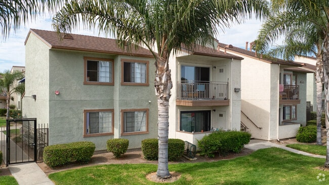
Property Record
644 Moss St, Chula Vista, CA 91911

Save to a Folder
{{folder.Name}}
{{folder.ListingIds.length}} Properties
{{folder.ListingIds.length}} Property
Create a New Folder
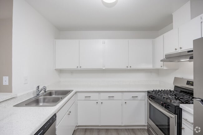
Property Detail
644 Moss St
618-010-30
QSEC 165 SEQ PARS 2 THRU 4 PER PM5153 IN S H OF S H OF TR 000505
Multifamilydwelling
San Diego
R3
California
C and X Area of minimal flood hazard, usually depicted on FIRMs as above the 500-year flood level.
6.03 AC
2025
Harborside
2025
San Diego
013103
San Diego-Chula Vista-Carlsbad, CA
NEARBY LISTINGS FOR SALE OR LEASE
DEMOGRAPHICS near 644 Moss St
1 mile
3 mile
5 mile
2025 Total Population
25,166
171,434
360,974
2030 Population
25,030
171,434
360,492
Pop Growth 2025-2030
(0.54%)
0.00%
(0.13%)
Average Age
37
39
39
2025 Total Households
7,861
53,761
109,147
HH Growth 2025-2030
(0.76%)
(0.12%)
(0.23%)
Median Household Inc
$67,344
$76,267
$85,490
Avg Household Size
3.10
3.10
3.20
2025 Avg HH Vehicles
2.00
2.00
2.00
Median Home Value
$628,557
$670,908
$708,832
Median Year Built
1966
1969
1974
Nearby Places
Map Layers
Map Styles
 Street
 Aerial
Layers
 Traffic
 Biking
Places
Listings with unknown addresses are not visible on the map
- Restaurants
- Banks
- Shops
- Fitness
- Groceries
PUBLIC TRANSPORTATION
TRANSIT/SUBWAY
Palomar Street (Blue Line - San Diego Metropolitan Transit System Trolley (San Diego Trolley))
Drive
Walk
Distance
Palomar Street (Blue Line - San Diego Metropolitan Transit System Trolley (San Diego Trolley))
3 min
19 min
1.0 mi
AIRPORT
San Diego International
Drive
Walk
Distance
San Diego International
17 min
12.9 mi
Freight Ports
Port of San Diego
Drive
Walk
Distance
Port of San Diego
13 min
8.9 mi
Nearby Properties
Address
Land Use
TOTAL SIZE
Lot Size
Zoning
Address
Land Use
TOTAL SIZE
Lot Size
Zoning
19.28 AC
60
Address
Land Use
TOTAL SIZE
Lot Size
Zoning
17.38 AC
UNZ
Address
Land Use
TOTAL SIZE
Lot Size
Zoning
11.42 AC
CP
Address
Land Use
TOTAL SIZE
Lot Size
Zoning
24.70 AC
C-6
Address
Land Use
TOTAL SIZE
Lot Size
Zoning
25.35 AC
UC-7
Address
Land Use
TOTAL SIZE
Lot Size
Zoning
15 AC
UC-14
Address
Land Use
TOTAL SIZE
Lot Size
Zoning
9.84 AC
C
Address
Land Use
TOTAL SIZE
Lot Size
Zoning
24.06 AC
R3
Address
Land Use
TOTAL SIZE
Lot Size
Zoning
8.96 AC
UC-4
Address
Land Use
TOTAL SIZE
Lot Size
Zoning
2.81 AC
IP
Address
Land Use
TOTAL SIZE
Lot Size
Zoning
34,200 SF
1.38 AC
CCPD-R
Address
Land Use
TOTAL SIZE
Lot Size
Zoning
6.85 AC
IL
Address
Land Use
TOTAL SIZE
Lot Size
Zoning
4.70 AC
R3
Address
Land Use
TOTAL SIZE
Lot Size
Zoning
6.67 AC
RM-2-5
Address
Land Use
TOTAL SIZE
Lot Size
Zoning
16,410 SF
UNZ
Address
Land Use
TOTAL SIZE
Lot Size
Zoning
77,397 SF
4.10 AC
R3
Address
Land Use
TOTAL SIZE
Lot Size
Zoning
4.80 AC
MXD-2
Address
Land Use
TOTAL SIZE
Lot Size
Zoning
7.52 AC
CTP
Address
Land Use
TOTAL SIZE
Lot Size
Zoning
7.36 AC
RM-2-5
Address
Land Use
TOTAL SIZE
Lot Size
Zoning
1.05 AC
C-1
Address
Land Use
TOTAL SIZE
Lot Size
Zoning
9.44 AC
PC
Address
Land Use
TOTAL SIZE
Lot Size
Zoning
5.28 AC
CC-4-5
Address
Land Use
TOTAL SIZE
Lot Size
Zoning
9,999 SF
9.10 AC
RM-1-1
Address
Land Use
TOTAL SIZE
Lot Size
Zoning
1.43 AC
UC-2
Address
Land Use
TOTAL SIZE
Lot Size
Zoning
1.88 AC
UC-2
Address
Land Use
TOTAL SIZE
Lot Size
Zoning
1.43 AC
UC-2
Address
Land Use
TOTAL SIZE
Lot Size
Zoning
4.71 AC
R3
Address
Land Use
TOTAL SIZE
Lot Size
Zoning
67,850 SF
4.90 AC
RM-1-1
Address
Land Use
TOTAL SIZE
Lot Size
Zoning
9,724 SF
2.38 AC
V-3
The World's #1 Commercial Real Estate Marketplace
Connect with us
© 2026 CoStar Group
The information above has been obtained from sources believed reliable. While we do not doubt its accuracy we have not verified it and make no guarantee, warranty or representation about it. It is your responsibility to independently confirm its accuracy and completeness. Any projections, opinions, assumptions, or estimates used are for example only and do not represent the current or future performance of the property. The value of this transaction to you depends on tax and other factors which should be evaluated by your tax, financial, and legal advisors. You and your advisors should conduct a careful, independent investigation of the property to determine to your satisfaction the suitability of the property for your needs.