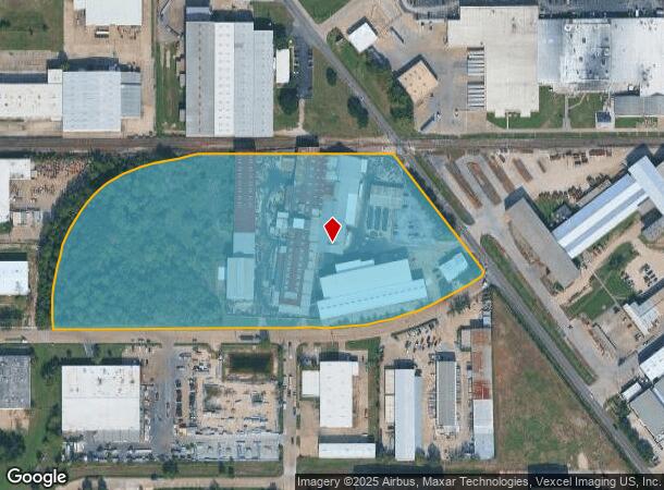
Property Record
6505 N Houston Rosslyn Rd, Houston, TX 77091
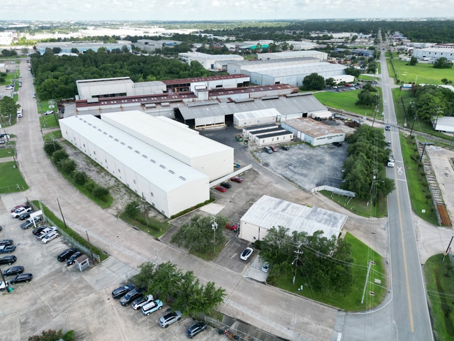
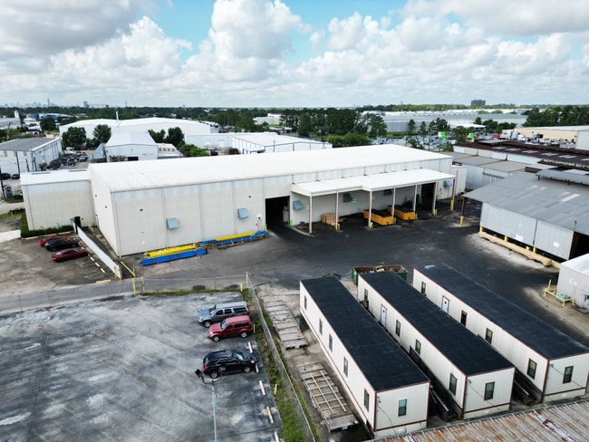
This Property Is For Sale
Current Lease Availabilities
NEARBY LISTINGS FOR SALE OR LEASE
Property Detail
6505 N Houston Rosslyn Rd
0430120000044
Abst 346 A G Holland
Industrialgeneral
TRS 1C 43 44 & 45 & RES C C1 & C2 BURLINGTON INDUST DIST SEC 1 ABST 346 A G HOLLAND
X
Harris
48201C0655M
Texas
2024
13.87 AC
2025
Northwest Near
532200
Houston
167,449 SF
Houston-The Woodlands-Sugar Land, TX
DEMOGRAPHICS near 6505 N Houston Rosslyn Rd
1 Mile
3 Mile
5 Mile
2024 Total Population
16,767
124,327
337,550
2029 Population
17,197
126,697
345,152
Pop Growth 2024-2029
+ 2.56%
+ 1.91%
+ 2.25%
Average Age
33
36
36
2024 Total Households
6,109
43,582
117,562
HH Growth 2024-2029
+ 2.59%
+ 1.84%
+ 2.34%
Median Household Inc
$34,334
$44,672
$52,491
Avg Household Size
2.70
2.80
2.80
2024 Avg HH Vehicles
2.00
2.00
2.00
Median Home Value
$172,530
$190,970
$234,731
Median Year Built
1978
1978
1978
Nearby Places
Map Layers
Map Styles
 Street
 Aerial
- Restaurants
- Banks
- Shops
- Fitness
- Groceries
PUBLIC TRANSPORTATION
AIRPORT
George Bush Intcntl/Houston
DRIVE
WALK
Distance
George Bush Intcntl/Houston
27 min
18.9 mi
William P Hobby
DRIVE
WALK
Distance
William P Hobby
42 min
26.4 mi
Freight Ports
Port of Houston
DRIVE
WALK
Distance
Port of Houston
34 min
22.0 mi
Nearby Properties
Address
Land Use
TOTAL SIZE
Lot Size
Zoning
Address
Land Use
TOTAL SIZE
Lot Size
Zoning
350,655 SF
16.76 AC
Address
Land Use
TOTAL SIZE
Lot Size
Zoning
643,804 SF
31.40 AC
Address
Land Use
TOTAL SIZE
Lot Size
Zoning
397,248 SF
26.37 AC
Address
Land Use
TOTAL SIZE
Lot Size
Zoning
456,294 SF
19.02 AC
Address
Land Use
TOTAL SIZE
Lot Size
Zoning
308,168 SF
21.34 AC
Address
Land Use
TOTAL SIZE
Lot Size
Zoning
426,748 SF
26.09 AC
Address
Land Use
TOTAL SIZE
Lot Size
Zoning
401,600 SF
20.48 AC
Address
Land Use
TOTAL SIZE
Lot Size
Zoning
409,271 SF
20.70 AC
Address
Land Use
TOTAL SIZE
Lot Size
Zoning
447,480 SF
18.48 AC
Address
Land Use
TOTAL SIZE
Lot Size
Zoning
444,798 SF
17.17 AC
Address
Land Use
TOTAL SIZE
Lot Size
Zoning
185,252 SF
17.14 AC
Address
Land Use
TOTAL SIZE
Lot Size
Zoning
336,050 SF
14.41 AC
Address
Land Use
TOTAL SIZE
Lot Size
Zoning
330,161 SF
20.90 AC
Address
Land Use
TOTAL SIZE
Lot Size
Zoning
268,678 SF
14 AC
Address
Land Use
TOTAL SIZE
Lot Size
Zoning
257,400 SF
13.34 AC
Address
Land Use
TOTAL SIZE
Lot Size
Zoning
299,640 SF
13.95 AC
Address
Land Use
TOTAL SIZE
Lot Size
Zoning
145,132 SF
3.69 AC
Address
Land Use
TOTAL SIZE
Lot Size
Zoning
206,777 SF
8.77 AC
Address
Land Use
TOTAL SIZE
Lot Size
Zoning
252,080 SF
13.92 AC
Address
Land Use
TOTAL SIZE
Lot Size
Zoning
201,947 SF
8.80 AC
Address
Land Use
TOTAL SIZE
Lot Size
Zoning
244,727 SF
10.49 AC
Address
Land Use
TOTAL SIZE
Lot Size
Zoning
358,164 SF
14.79 AC
Address
Land Use
TOTAL SIZE
Lot Size
Zoning
217,700 SF
16.16 AC
Address
Land Use
TOTAL SIZE
Lot Size
Zoning
437,052 SF
15.90 AC
Address
Land Use
TOTAL SIZE
Lot Size
Zoning
339,500 SF
17.05 AC
Address
Land Use
TOTAL SIZE
Lot Size
Zoning
322,748 SF
12.23 AC
Address
Land Use
TOTAL SIZE
Lot Size
Zoning
234,215 SF
5.67 AC
Address
Land Use
TOTAL SIZE
Lot Size
Zoning
282,024 SF
13.13 AC
Address
Land Use
TOTAL SIZE
Lot Size
Zoning
232,702 SF
14.75 AC
Address
Land Use
TOTAL SIZE
Lot Size
Zoning
211,344 SF
13.32 AC
The World's #1 Commercial Real Estate Marketplace
Connect with us
© 2026 CoStar Group
The information above has been obtained from sources believed reliable. While we do not doubt its accuracy we have not verified it and make no guarantee, warranty or representation about it. It is your responsibility to independently confirm its accuracy and completeness. Any projections, opinions, assumptions, or estimates used are for example only and do not represent the current or future performance of the property. The value of this transaction to you depends on tax and other factors which should be evaluated by your tax, financial, and legal advisors. You and your advisors should conduct a careful, independent investigation of the property to determine to your satisfaction the suitability of the property for your needs.