Property Record
6505 Quail St, Arvada, CO 80004

NEARBY LISTINGS FOR SALE OR LEASE
-
-
View all Arvada listings for sale on LoopNet.com
Property Detail
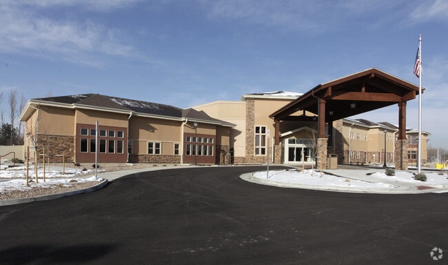
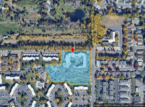
6505 Quail St
Denver-Aurora-Centennial, CO
Gardens On Quail Street
39-043-10-051
SECTION 04 TOWNSHIP 03 RANGE 69 QTR SW SUBDIVISIONCD 262520 SUBDIVISIONNAME GARDENS ON QUAIL STREET BLOCK LOT 0001 SIZE: 195306 TRACT VALUE: 4.484
Multifamilydwelling
Jefferson
X
Colorado
08059C0203F
1
2023
4.48 AC
2024
Northwest Denver
010303
Denver
85,255 SF
DEMOGRAPHICS near 6505 Quail St
1 Mile
3 Mile
5 Mile
2024 Total Population
16,179
96,483
229,474
2029 Population
15,947
95,471
228,145
Pop Growth 2024-2029
(1.43%)
(1.05%)
(0.58%)
Average Age
43
42
41
2024 Total Households
6,460
39,745
93,868
HH Growth 2024-2029
(1.58%)
(1.11%)
(0.62%)
Median Household Inc
$89,476
$95,372
$91,096
Avg Household Size
2.40
2.40
2.40
2024 Avg HH Vehicles
2.00
2.00
2.00
Median Home Value
$493,042
$561,890
$543,286
Median Year Built
1971
1977
1976
Nearby Places
Map Layers
Map Styles
 Street
 Aerial
- Restaurants
- Banks
- Shops
- Fitness
- Groceries
PUBLIC TRANSPORTATION
COMMUTER RAIL
Arvada Ridge Station Track 1 (Union Station to Wheat Ridge Ward Station - Regional Transportation District)
DRIVE
WALK
Distance
Arvada Ridge Station Track 1 (Union Station to Wheat Ridge Ward Station - Regional Transportation District)
5 min
2.6 mi
Arvada Ridge Station Track 2 (Union Station to Wheat Ridge Ward Station - Regional Transportation District)
DRIVE
WALK
Distance
Arvada Ridge Station Track 2 (Union Station to Wheat Ridge Ward Station - Regional Transportation District)
5 min
2.6 mi
AIRPORT
Denver International
DRIVE
WALK
Distance
Denver International
42 min
32.0 mi
Freight Ports
Tulsa Port Of Catoosa
DRIVE
WALK
Distance
Tulsa Port Of Catoosa
739 min
717.5 mi
Nearby Properties
Address
Land Use
TOTAL SIZE
Lot Size
Zoning
Address
Land Use
TOTAL SIZE
Lot Size
Zoning
269,013 SF
31.89 AC
Address
Land Use
TOTAL SIZE
Lot Size
Zoning
253,643 SF
50.87 AC
A2
Address
Land Use
TOTAL SIZE
Lot Size
Zoning
389,561 SF
10.73 AC
Address
Land Use
TOTAL SIZE
Lot Size
Zoning
215,878 SF
11.82 AC
A2
Address
Land Use
TOTAL SIZE
Lot Size
Zoning
131,135 SF
2.83 AC
Address
Land Use
TOTAL SIZE
Lot Size
Zoning
262,699 SF
13.10 AC
A2
Address
Land Use
TOTAL SIZE
Lot Size
Zoning
363,989 SF
30.10 AC
Address
Land Use
TOTAL SIZE
Lot Size
Zoning
101,761 SF
4.34 AC
Address
Land Use
TOTAL SIZE
Lot Size
Zoning
142,200 SF
9.82 AC
Address
Land Use
TOTAL SIZE
Lot Size
Zoning
162,509 SF
11.84 AC
Address
Land Use
TOTAL SIZE
Lot Size
Zoning
149,115 SF
18 AC
Address
Land Use
TOTAL SIZE
Lot Size
Zoning
91,734 SF
9.69 AC
Address
Land Use
TOTAL SIZE
Lot Size
Zoning
113,903 SF
12.25 AC
Address
Land Use
TOTAL SIZE
Lot Size
Zoning
33,506 SF
9.98 AC
A2
Address
Land Use
TOTAL SIZE
Lot Size
Zoning
82,055 SF
19.39 AC
Address
Land Use
TOTAL SIZE
Lot Size
Zoning
68,300 SF
6 AC
Address
Land Use
TOTAL SIZE
Lot Size
Zoning
174,853 SF
14.68 AC
Address
Land Use
TOTAL SIZE
Lot Size
Zoning
169,525 SF
2.93 AC
Address
Land Use
TOTAL SIZE
Lot Size
Zoning
67,520 SF
6.46 AC
Address
Land Use
TOTAL SIZE
Lot Size
Zoning
51,987 SF
15.23 AC
PD
Address
Land Use
TOTAL SIZE
Lot Size
Zoning
83,684 SF
8.15 AC
Address
Land Use
TOTAL SIZE
Lot Size
Zoning
150,321 SF
6.52 AC
Address
Land Use
TOTAL SIZE
Lot Size
Zoning
224,923 SF
33.71 AC
Address
Land Use
TOTAL SIZE
Lot Size
Zoning
201,582 SF
5.78 AC
Address
Land Use
TOTAL SIZE
Lot Size
Zoning
22,524 SF
3.74 AC
Address
Land Use
TOTAL SIZE
Lot Size
Zoning
265,676 SF
2.03 AC
Address
Land Use
TOTAL SIZE
Lot Size
Zoning
67,879 SF
9.91 AC
A2
Address
Land Use
TOTAL SIZE
Lot Size
Zoning
437,083 SF
27.42 AC
Address
Land Use
TOTAL SIZE
Lot Size
Zoning
54,236 SF
8.72 AC
Address
Land Use
TOTAL SIZE
Lot Size
Zoning
152,536 SF
15.14 AC
The World's #1 Commercial Real Estate Marketplace
Connect with us
© 2026 CoStar Group
The information above has been obtained from sources believed reliable. While we do not doubt its accuracy we have not verified it and make no guarantee, warranty or representation about it. It is your responsibility to independently confirm its accuracy and completeness. Any projections, opinions, assumptions, or estimates used are for example only and do not represent the current or future performance of the property. The value of this transaction to you depends on tax and other factors which should be evaluated by your tax, financial, and legal advisors. You and your advisors should conduct a careful, independent investigation of the property to determine to your satisfaction the suitability of the property for your needs.