Property Record
6505 S 57Th West Ave, Tulsa, OK 74131
NEARBY LISTINGS FOR SALE OR LEASE
Property Detail
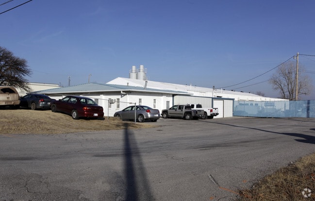
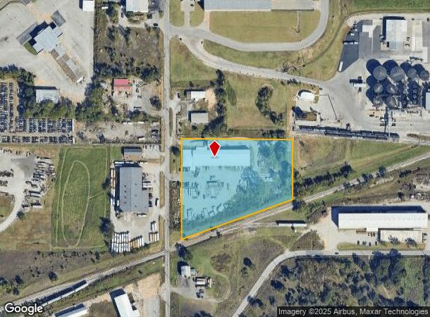
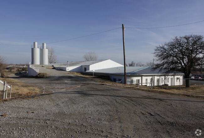
6505 S 57Th West Ave
Tulsa, OK
Unplatted Sapulpa
1999-05-018-012-0-008-00
5-18-12 POR W NE BEG 76.51 N& 30 P OF SW COR SAID PT BEING ON N R W LNE OUR N450 E500 S269 TO PT ON N R W OUR TH SW AL N R W
Manufacturinglight
Creek
X
Oklahoma
40143C0333L
12
2024
5.29 AC
2025
Creek County
020101
Tulsa
17,750 SF
DEMOGRAPHICS near 6505 S 57Th West Ave
1 Mile
3 Mile
5 Mile
2024 Total Population
1,613
23,835
67,616
2029 Population
1,685
24,581
70,016
Pop Growth 2024-2029
+ 4.46%
+ 3.13%
+ 3.55%
Average Age
41
40
39
2024 Total Households
592
9,403
28,014
HH Growth 2024-2029
+ 4.56%
+ 2.91%
+ 3.51%
Median Household Inc
$52,241
$57,643
$56,240
Avg Household Size
2.60
2.40
2.30
2024 Avg HH Vehicles
2.00
2.00
2.00
Median Home Value
$131,200
$167,577
$167,969
Median Year Built
1977
1978
1978
Nearby Places
Map Layers
Map Styles
 Street
 Aerial
- Restaurants
- Banks
- Shops
- Fitness
- Groceries
PUBLIC TRANSPORTATION
AIRPORT
Tulsa International
DRIVE
WALK
Distance
Tulsa International
25 min
16.7 mi
Freight Ports
Tulsa Port Of Catoosa
DRIVE
WALK
Distance
Tulsa Port Of Catoosa
35 min
26.0 mi
Nearby Properties
Address
Land Use
TOTAL SIZE
Lot Size
Zoning
Address
Land Use
TOTAL SIZE
Lot Size
Zoning
1,134,776 SF
35.85 AC
CN
Address
Land Use
TOTAL SIZE
Lot Size
Zoning
290,963 SF
10.77 AC
RM1
Address
Land Use
TOTAL SIZE
Lot Size
Zoning
119,056 SF
28.06 AC
CM
Address
Land Use
TOTAL SIZE
Lot Size
Zoning
110,382 SF
9.81 AC
RS3
Address
Land Use
TOTAL SIZE
Lot Size
Zoning
35,845 SF
14.38 AC
CS
Address
Land Use
TOTAL SIZE
Lot Size
Zoning
270,584 SF
28.85 AC
CO
Address
Land Use
TOTAL SIZE
Lot Size
Zoning
143,520 SF
25.14 AC
IM
Address
Land Use
TOTAL SIZE
Lot Size
Zoning
47,670 SF
10.05 AC
RS
Address
Land Use
TOTAL SIZE
Lot Size
Zoning
22,078 SF
5.08 AC
CS
Address
Land Use
TOTAL SIZE
Lot Size
Zoning
23,269 SF
263.40 AC
NCU
Address
Land Use
TOTAL SIZE
Lot Size
Zoning
136,079 SF
9 AC
CO
Address
Land Use
TOTAL SIZE
Lot Size
Zoning
301,395 SF
13.07 AC
CO
Address
Land Use
TOTAL SIZE
Lot Size
Zoning
32,722 SF
8.40 AC
RS3
Address
Land Use
TOTAL SIZE
Lot Size
Zoning
32,672 SF
8.56 AC
CS
Address
Land Use
TOTAL SIZE
Lot Size
Zoning
1,025 SF
64.46 AC
AG
Address
Land Use
TOTAL SIZE
Lot Size
Zoning
251,601 SF
16.75 AC
RM1
Address
Land Use
TOTAL SIZE
Lot Size
Zoning
117,372 SF
11.87 AC
CN
Address
Land Use
TOTAL SIZE
Lot Size
Zoning
20,771 SF
1.11 AC
RS3
Address
Land Use
TOTAL SIZE
Lot Size
Zoning
370,891 SF
26.43 AC
IM
Address
Land Use
TOTAL SIZE
Lot Size
Zoning
16,000 SF
5 AC
CS
Address
Land Use
TOTAL SIZE
Lot Size
Zoning
38,940 SF
16.24 AC
Address
Land Use
TOTAL SIZE
Lot Size
Zoning
15,066 SF
2.16 AC
RS3
Address
Land Use
TOTAL SIZE
Lot Size
Zoning
2,152 SF
8.88 AC
Address
Land Use
TOTAL SIZE
Lot Size
Zoning
31,600 SF
13.46 AC
Address
Land Use
TOTAL SIZE
Lot Size
Zoning
25,685 SF
5.04 AC
Address
Land Use
TOTAL SIZE
Lot Size
Zoning
40,069 SF
4.22 AC
RM0
Address
Land Use
TOTAL SIZE
Lot Size
Zoning
54,194 SF
3.27 AC
CO
Address
Land Use
TOTAL SIZE
Lot Size
Zoning
14.24 AC
RM1
Address
Land Use
TOTAL SIZE
Lot Size
Zoning
18,794 SF
2.95 AC
CN
Address
Land Use
TOTAL SIZE
Lot Size
Zoning
50,050 SF
6.13 AC
CN
The World's #1 Commercial Real Estate Marketplace
Connect with us
© 2025 CoStar Group
The information above has been obtained from sources believed reliable. While we do not doubt its accuracy we have not verified it and make no guarantee, warranty or representation about it. It is your responsibility to independently confirm its accuracy and completeness. Any projections, opinions, assumptions, or estimates used are for example only and do not represent the current or future performance of the property. The value of this transaction to you depends on tax and other factors which should be evaluated by your tax, financial, and legal advisors. You and your advisors should conduct a careful, independent investigation of the property to determine to your satisfaction the suitability of the property for your needs.