Property Record
651 Christensen Ct, Mapleton, ND 58059
Property Detail
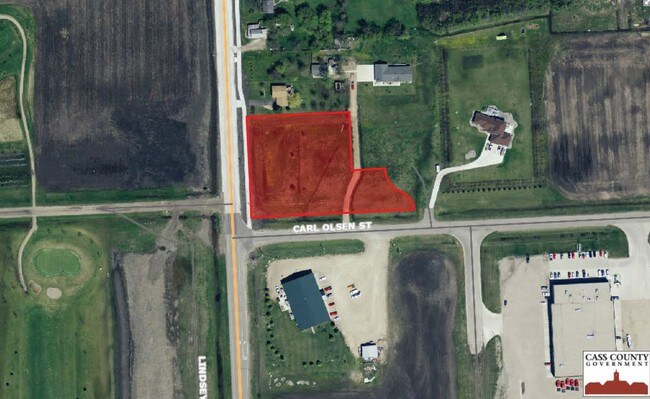
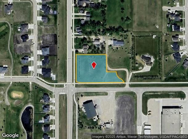
651 Christensen Ct
Other Market Areas
LOT: 1 BLOCK: 1 ADDITION: CARLS CORNER ADDITION ADDITIONAL: CARL'S CORNER ADDITION LT 1 BLK 1 LESS THE FOLL FOR EASEMENT: BEG AT THE SE COR OF SD LT 1 LK 1; THN S 87DG05'05' W ALG THE S LN OF SD CARL'S CORNER ADDN FOR A DIST OF 419.02' TO THE SW COR
Fargo, ND-MN
CASS
18-0350-00010-010
North Dakota
Residentialacreage
1
2024
0.15 AC
2024
Fargo
040800
NEARBY LISTINGS FOR SALE OR LEASE
DEMOGRAPHICS near 651 Christensen Ct
1 mile
3 mile
5 mile
2025 Total Population
1,598
1,689
1,946
2030 Population
1,733
1,829
2,106
Pop Growth 2025-2030
+ 8.45%
+ 8.29%
+ 8.22%
Average Age
36
36
36
2025 Total Households
555
588
682
HH Growth 2025-2030
+ 8.83%
+ 8.50%
+ 8.50%
Median Household Inc
$121,840
$121,262
$119,642
Avg Household Size
2.90
2.90
2.90
2025 Avg HH Vehicles
2.00
2.00
2.00
Median Home Value
$350,000
$350,000
$345,918
Median Year Built
1992
1991
1989
Nearby Places
Map Layers
Map Styles
 Street
 Aerial
Transit
 Traffic
 Biking
Places
Listings with unknown addresses are not visible on the map
- Restaurants
- Banks
- Shops
- Fitness
- Groceries
PUBLIC TRANSPORTATION
AIRPORT
Hector International
Drive
Walk
Distance
Hector International
27 min
16.5 mi
SALE & LEASE HISTORY
LISTING DATE
SALE/LEASE

Sep 24, 2016
For Sale
Oct 02, 2019
For Sale
Nearby Properties
Address
Land Use
TOTAL SIZE
Lot Size
Zoning
Address
Land Use
TOTAL SIZE
Lot Size
Zoning
106,400 SF
20 AC
Address
Land Use
TOTAL SIZE
Lot Size
Zoning
164,569 SF
2.47 AC
Address
Land Use
TOTAL SIZE
Lot Size
Zoning
50,962 SF
9.99 AC
Address
Land Use
TOTAL SIZE
Lot Size
Zoning
42,252 SF
9.53 AC
Address
Land Use
TOTAL SIZE
Lot Size
Zoning
1,624 SF
Address
Land Use
TOTAL SIZE
Lot Size
Zoning
48,762 SF
11.88 AC
Address
Land Use
TOTAL SIZE
Lot Size
Zoning
Address
Land Use
TOTAL SIZE
Lot Size
Zoning
21,410 SF
2.08 AC
Address
Land Use
TOTAL SIZE
Lot Size
Zoning
60,000 SF
6.50 AC
Address
Land Use
TOTAL SIZE
Lot Size
Zoning
1.85 AC
Address
Land Use
TOTAL SIZE
Lot Size
Zoning
Address
Land Use
TOTAL SIZE
Lot Size
Zoning
17,568 SF
2.83 AC
Address
Land Use
TOTAL SIZE
Lot Size
Zoning
12,600 SF
4.07 AC
Address
Land Use
TOTAL SIZE
Lot Size
Zoning
8,640 SF
1.74 AC
Address
Land Use
TOTAL SIZE
Lot Size
Zoning
2,240 SF
2.80 AC
Address
Land Use
TOTAL SIZE
Lot Size
Zoning
Address
Land Use
TOTAL SIZE
Lot Size
Zoning
10,756 SF
Address
Land Use
TOTAL SIZE
Lot Size
Zoning
Address
Land Use
TOTAL SIZE
Lot Size
Zoning
11,100 SF
1.57 AC
Address
Land Use
TOTAL SIZE
Lot Size
Zoning
9,666 SF
0.64 AC
Address
Land Use
TOTAL SIZE
Lot Size
Zoning
12,000 SF
2.25 AC
Address
Land Use
TOTAL SIZE
Lot Size
Zoning
2.06 AC
Address
Land Use
TOTAL SIZE
Lot Size
Zoning
10,080 SF
2 AC
Address
Land Use
TOTAL SIZE
Lot Size
Zoning
3,979 SF
Address
Land Use
TOTAL SIZE
Lot Size
Zoning
4,404 SF
Address
Land Use
TOTAL SIZE
Lot Size
Zoning
8.75 AC
Address
Land Use
TOTAL SIZE
Lot Size
Zoning
3,488 SF
7.29 AC
Address
Land Use
TOTAL SIZE
Lot Size
Zoning
Address
Land Use
TOTAL SIZE
Lot Size
Zoning
5,040 SF
100.27 AC
Address
Land Use
TOTAL SIZE
Lot Size
Zoning
4,096 SF
The World's #1 Commercial Real Estate Marketplace
Connect with us
© 2026 CoStar Group
The information above has been obtained from sources believed reliable. While we do not doubt its accuracy we have not verified it and make no guarantee, warranty or representation about it. It is your responsibility to independently confirm its accuracy and completeness. Any projections, opinions, assumptions, or estimates used are for example only and do not represent the current or future performance of the property. The value of this transaction to you depends on tax and other factors which should be evaluated by your tax, financial, and legal advisors. You and your advisors should conduct a careful, independent investigation of the property to determine to your satisfaction the suitability of the property for your needs.