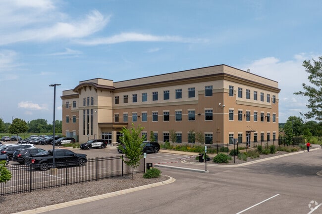
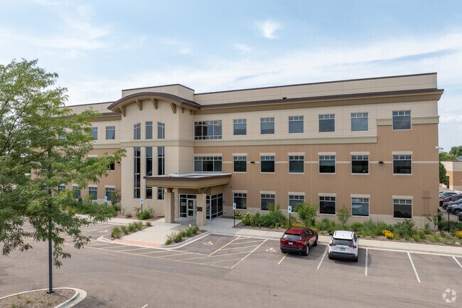
Property Record
651 Prairie Pointe Dr, Yorkville, IL 60560

NEARBY LISTINGS FOR SALE OR LEASE
Property Detail
651 Prairie Pointe Dr
Chicago-Naperville-Elgin, IL-IN-WI
Prairie Pointe
02-21-482-001
LOT 1 PRAIRIE POINTE CITY OF YORKVILLE
Taxexempt
Kendall
X
Illinois
17093C0045H
1
2022
4.34 AC
2024
Western East/West Corr
890402
Chicago
43,544 SF
DEMOGRAPHICS near 651 Prairie Pointe Dr
1 Mile
3 Mile
5 Mile
2024 Total Population
5,018
24,705
73,557
2029 Population
5,534
27,422
80,981
Pop Growth 2024-2029
+ 10.28%
+ 11.00%
+ 10.09%
Average Age
39
38
36
2024 Total Households
1,830
8,516
24,243
HH Growth 2024-2029
+ 10.22%
+ 10.97%
+ 10.25%
Median Household Inc
$89,338
$98,919
$100,604
Avg Household Size
2.70
2.80
3.00
2024 Avg HH Vehicles
2.00
2.00
2.00
Median Home Value
$274,428
$279,993
$267,659
Median Year Built
1991
2001
2002
Nearby Places
Map Layers
Map Styles
 Street
 Aerial
- Restaurants
- Banks
- Shops
- Fitness
- Groceries
PUBLIC TRANSPORTATION
COMMUTER RAIL
Plano Amtrak Station (Carl Sandburg - Amtrak, Illinois Zephyr - Amtrak)
DRIVE
WALK
Distance
Plano Amtrak Station (Carl Sandburg - Amtrak, Illinois Zephyr - Amtrak)
12 min
6.2 mi
Freight Ports
Port Milwaukee
DRIVE
WALK
Distance
Port Milwaukee
151 min
122.1 mi
SALE & LEASE HISTORY
LISTING DATE
SALE/LEASE

Sep 25, 2016
For Lease
Jun 30, 2020
For Sale
Dec 27, 2018
For Lease
Dec 22, 2016
For Lease
Nearby Properties
Address
Land Use
TOTAL SIZE
Lot Size
Zoning
Address
Land Use
TOTAL SIZE
Lot Size
Zoning
156,075 SF
16.27 AC
Address
Land Use
TOTAL SIZE
Lot Size
Zoning
339,430 SF
6.18 AC
Address
Land Use
TOTAL SIZE
Lot Size
Zoning
64,667 SF
6.15 AC
Address
Land Use
TOTAL SIZE
Lot Size
Zoning
184,454 SF
8.05 AC
Address
Land Use
TOTAL SIZE
Lot Size
Zoning
211,068 SF
13.09 AC
Address
Land Use
TOTAL SIZE
Lot Size
Zoning
177,481 SF
14.11 AC
Address
Land Use
TOTAL SIZE
Lot Size
Zoning
64,781 SF
1.62 AC
Address
Land Use
TOTAL SIZE
Lot Size
Zoning
62,164 SF
6.76 AC
Address
Land Use
TOTAL SIZE
Lot Size
Zoning
15,913 SF
31.25 AC
Address
Land Use
TOTAL SIZE
Lot Size
Zoning
108,848 SF
5.79 AC
Address
Land Use
TOTAL SIZE
Lot Size
Zoning
107,162 SF
10.49 AC
Address
Land Use
TOTAL SIZE
Lot Size
Zoning
16,100 SF
5.14 AC
Address
Land Use
TOTAL SIZE
Lot Size
Zoning
21,800 SF
2.79 AC
Address
Land Use
TOTAL SIZE
Lot Size
Zoning
58,960 SF
1.27 AC
Address
Land Use
TOTAL SIZE
Lot Size
Zoning
16,152 SF
2.40 AC
Address
Land Use
TOTAL SIZE
Lot Size
Zoning
54,910 SF
0.88 AC
Address
Land Use
TOTAL SIZE
Lot Size
Zoning
38,500 SF
7.06 AC
Address
Land Use
TOTAL SIZE
Lot Size
Zoning
8,056 SF
2.64 AC
Address
Land Use
TOTAL SIZE
Lot Size
Zoning
4,968 SF
1.35 AC
Address
Land Use
TOTAL SIZE
Lot Size
Zoning
19,012 SF
3.02 AC
Address
Land Use
TOTAL SIZE
Lot Size
Zoning
59,106 SF
3.46 AC
Address
Land Use
TOTAL SIZE
Lot Size
Zoning
60,078 SF
3.18 AC
Address
Land Use
TOTAL SIZE
Lot Size
Zoning
90,533 SF
7.18 AC
Address
Land Use
TOTAL SIZE
Lot Size
Zoning
52,278 SF
1.75 AC
Address
Land Use
TOTAL SIZE
Lot Size
Zoning
20,850 SF
1.06 AC
Address
Land Use
TOTAL SIZE
Lot Size
Zoning
121,275 SF
15.67 AC
Address
Land Use
TOTAL SIZE
Lot Size
Zoning
3,538 SF
2.47 AC
Address
Land Use
TOTAL SIZE
Lot Size
Zoning
5,108 SF
1.70 AC
Address
Land Use
TOTAL SIZE
Lot Size
Zoning
21,620 SF
1.45 AC
The World's #1 Commercial Real Estate Marketplace
Connect with us
© 2026 CoStar Group
The information above has been obtained from sources believed reliable. While we do not doubt its accuracy we have not verified it and make no guarantee, warranty or representation about it. It is your responsibility to independently confirm its accuracy and completeness. Any projections, opinions, assumptions, or estimates used are for example only and do not represent the current or future performance of the property. The value of this transaction to you depends on tax and other factors which should be evaluated by your tax, financial, and legal advisors. You and your advisors should conduct a careful, independent investigation of the property to determine to your satisfaction the suitability of the property for your needs.