Property Record
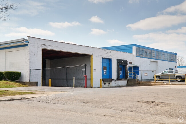
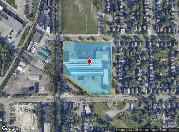
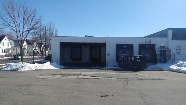
655 Driving Park Ave, Rochester, NY 14613
Current Lease Availabilities
NEARBY LISTINGS FOR SALE OR LEASE
Property Detail
655 Driving Park Ave
261400-090-800-0002-003-000-0000
0022.00 404 10 01454 1 TO 18 SEC 7& 8 EDGAR HOLMES SUB
Manufacturinglight
Monroe
X
New York
36055C0192G
3.000
2025
5.01 AC
2024
Greater Rochester
002200
Rochester
100,000 SF
Rochester, NY
DEMOGRAPHICS near 655 Driving Park Ave
1 Mile
3 Mile
5 Mile
2024 Total Population
21,051
136,490
319,485
2029 Population
20,629
134,520
314,470
Pop Growth 2024-2029
(2.00%)
(1.44%)
(1.57%)
Average Age
34
37
39
2024 Total Households
7,747
57,139
139,685
HH Growth 2024-2029
(2.07%)
(1.38%)
(1.61%)
Median Household Inc
$38,998
$41,567
$51,171
Avg Household Size
2.50
2.30
2.20
2024 Avg HH Vehicles
1.00
1.00
1.00
Median Home Value
$64,035
$98,883
$134,336
Median Year Built
1946
1950
1952
Nearby Places
Map Layers
Map Styles
 Street
 Aerial
- Restaurants
- Banks
- Shops
- Fitness
- Groceries
PUBLIC TRANSPORTATION
COMMUTER RAIL
Rochester (Empire Service - VIA Rail, Lake Shore Limited - VIA Rail, Maple Leaf - VIA Rail, Toronto - New York - VIA Rail)
DRIVE
WALK
Distance
Rochester (Empire Service - VIA Rail, Lake Shore Limited - VIA Rail, Maple Leaf - VIA Rail, Toronto - New York - VIA Rail)
7 min
3.3 mi
AIRPORT
Frederick Douglass/Greater Rochester International
DRIVE
WALK
Distance
Frederick Douglass/Greater Rochester International
12 min
6.8 mi
Freight Ports
Albany, NY Port
DRIVE
WALK
Distance
Albany, NY Port
272 min
229.9 mi
Nearby Properties
Address
Land Use
TOTAL SIZE
Lot Size
Zoning
Address
Land Use
TOTAL SIZE
Lot Size
Zoning
0.47 AC
Address
Land Use
TOTAL SIZE
Lot Size
Zoning
0.13 AC
Address
Land Use
TOTAL SIZE
Lot Size
Zoning
181,500 SF
57.85 AC
Address
Land Use
TOTAL SIZE
Lot Size
Zoning
64,041 SF
42.66 AC
Address
Land Use
TOTAL SIZE
Lot Size
Zoning
41,376 SF
59.90 AC
06 - INDUS
Address
Land Use
TOTAL SIZE
Lot Size
Zoning
18,831 SF
70.63 AC
Address
Land Use
TOTAL SIZE
Lot Size
Zoning
13.10 AC
Address
Land Use
TOTAL SIZE
Lot Size
Zoning
373,200 SF
5.42 AC
Address
Land Use
TOTAL SIZE
Lot Size
Zoning
178,321 SF
3.10 AC
Address
Land Use
TOTAL SIZE
Lot Size
Zoning
0.01 AC
Address
Land Use
TOTAL SIZE
Lot Size
Zoning
302,484 SF
2.53 AC
Address
Land Use
TOTAL SIZE
Lot Size
Zoning
473,876 SF
1.49 AC
Address
Land Use
TOTAL SIZE
Lot Size
Zoning
342,266 SF
1.44 AC
Address
Land Use
TOTAL SIZE
Lot Size
Zoning
7,200 SF
12.35 AC
Address
Land Use
TOTAL SIZE
Lot Size
Zoning
0.01 AC
Address
Land Use
TOTAL SIZE
Lot Size
Zoning
416,083 SF
0.94 AC
Address
Land Use
TOTAL SIZE
Lot Size
Zoning
0.01 AC
Address
Land Use
TOTAL SIZE
Lot Size
Zoning
491,375 SF
5.90 AC
Address
Land Use
TOTAL SIZE
Lot Size
Zoning
273,900 SF
0.74 AC
Address
Land Use
TOTAL SIZE
Lot Size
Zoning
336,447 SF
1.38 AC
Address
Land Use
TOTAL SIZE
Lot Size
Zoning
151,590 SF
1.14 AC
Address
Land Use
TOTAL SIZE
Lot Size
Zoning
233,579 SF
1.13 AC
Address
Land Use
TOTAL SIZE
Lot Size
Zoning
410,400 SF
2.88 AC
Address
Land Use
TOTAL SIZE
Lot Size
Zoning
261,960 SF
3.73 AC
Address
Land Use
TOTAL SIZE
Lot Size
Zoning
1.06 AC
Address
Land Use
TOTAL SIZE
Lot Size
Zoning
14,219 SF
2.34 AC
Address
Land Use
TOTAL SIZE
Lot Size
Zoning
619,686 SF
2.30 AC
Address
Land Use
TOTAL SIZE
Lot Size
Zoning
2.63 AC
Address
Land Use
TOTAL SIZE
Lot Size
Zoning
177,523 SF
1.55 AC
Address
Land Use
TOTAL SIZE
Lot Size
Zoning
273,663 SF
80.37 AC
The World's #1 Commercial Real Estate Marketplace
Connect with us
© 2025 CoStar Group
The information above has been obtained from sources believed reliable. While we do not doubt its accuracy we have not verified it and make no guarantee, warranty or representation about it. It is your responsibility to independently confirm its accuracy and completeness. Any projections, opinions, assumptions, or estimates used are for example only and do not represent the current or future performance of the property. The value of this transaction to you depends on tax and other factors which should be evaluated by your tax, financial, and legal advisors. You and your advisors should conduct a careful, independent investigation of the property to determine to your satisfaction the suitability of the property for your needs.