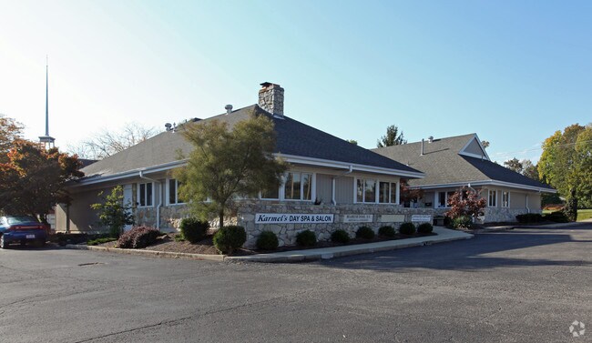
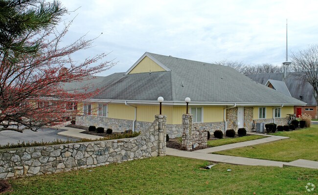
Property Record
6550 N Main St, Dayton, OH 45415


NEARBY LISTINGS FOR SALE OR LEASE
Property Detail
6550 N Main St
Dayton, OH
Singing Woods Park
E20-24414-0002
2 SINGING WOODS PARK SEC 1
Medicalbuilding
Montgomery
X
Ohio
39113C0153E
2
2024
0.93 AC
2025
North Dayton
080200
Cincinnati/Dayton
6,341 SF
DEMOGRAPHICS near 6550 N Main St
1 Mile
3 Mile
5 Mile
2024 Total Population
4,708
57,920
137,800
2029 Population
4,614
57,564
138,494
Pop Growth 2024-2029
(2.00%)
(0.61%)
+ 0.50%
Average Age
46
41
41
2024 Total Households
2,174
25,485
60,181
HH Growth 2024-2029
(2.16%)
(0.67%)
+ 0.46%
Median Household Inc
$50,076
$45,774
$44,622
Avg Household Size
2.00
2.20
2.20
2024 Avg HH Vehicles
2.00
2.00
2.00
Median Home Value
$152,706
$130,360
$116,693
Median Year Built
1965
1961
1961
Nearby Places
Map Layers
Map Styles
 Street
 Aerial
- Restaurants
- Banks
- Shops
- Fitness
- Groceries
PUBLIC TRANSPORTATION
AIRPORT
James M Cox Dayton International
DRIVE
WALK
Distance
James M Cox Dayton International
14 min
6.6 mi
SALE & LEASE HISTORY
LISTING DATE
SALE/LEASE

Sep 24, 2016
For Sale
Mar 30, 2017
For Sale
Jun 07, 2017
For Sale
Apr 06, 2017
For Sale
Nearby Properties
Address
Land Use
TOTAL SIZE
Lot Size
Zoning
Address
Land Use
TOTAL SIZE
Lot Size
Zoning
104,192 SF
923.52 AC
Address
Land Use
TOTAL SIZE
Lot Size
Zoning
562,815 SF
41.46 AC
Address
Land Use
TOTAL SIZE
Lot Size
Zoning
678,154 SF
1,128.84 AC
Address
Land Use
TOTAL SIZE
Lot Size
Zoning
5.92 AC
Address
Land Use
TOTAL SIZE
Lot Size
Zoning
20.16 AC
Address
Land Use
TOTAL SIZE
Lot Size
Zoning
100,716 SF
4.31 AC
Address
Land Use
TOTAL SIZE
Lot Size
Zoning
505,736 SF
45.42 AC
Address
Land Use
TOTAL SIZE
Lot Size
Zoning
313,421 SF
19.55 AC
Address
Land Use
TOTAL SIZE
Lot Size
Zoning
92,192 SF
41.46 AC
Address
Land Use
TOTAL SIZE
Lot Size
Zoning
558,933 SF
19.55 AC
Address
Land Use
TOTAL SIZE
Lot Size
Zoning
200,716 SF
32.06 AC
Address
Land Use
TOTAL SIZE
Lot Size
Zoning
10.87 AC
Address
Land Use
TOTAL SIZE
Lot Size
Zoning
220,548 SF
23.11 AC
Address
Land Use
TOTAL SIZE
Lot Size
Zoning
509,060 SF
31.03 AC
Address
Land Use
TOTAL SIZE
Lot Size
Zoning
12,924 SF
51.34 AC
Address
Land Use
TOTAL SIZE
Lot Size
Zoning
6.25 AC
Address
Land Use
TOTAL SIZE
Lot Size
Zoning
94,671 SF
6.42 AC
Address
Land Use
TOTAL SIZE
Lot Size
Zoning
92,440 SF
3.01 AC
Address
Land Use
TOTAL SIZE
Lot Size
Zoning
23.29 AC
Address
Land Use
TOTAL SIZE
Lot Size
Zoning
101,698 SF
19.06 AC
Address
Land Use
TOTAL SIZE
Lot Size
Zoning
92,615 SF
2.68 AC
Address
Land Use
TOTAL SIZE
Lot Size
Zoning
243,256 SF
13.58 AC
Address
Land Use
TOTAL SIZE
Lot Size
Zoning
46,592 SF
5.32 AC
Address
Land Use
TOTAL SIZE
Lot Size
Zoning
17.54 AC
Address
Land Use
TOTAL SIZE
Lot Size
Zoning
57,467 SF
5.33 AC
Address
Land Use
TOTAL SIZE
Lot Size
Zoning
68,196 SF
3.55 AC
Address
Land Use
TOTAL SIZE
Lot Size
Zoning
92,782 SF
12.44 AC
Address
Land Use
TOTAL SIZE
Lot Size
Zoning
10.06 AC
Address
Land Use
TOTAL SIZE
Lot Size
Zoning
71,363 SF
4 AC
Address
Land Use
TOTAL SIZE
Lot Size
Zoning
82,316 SF
13.34 AC
The World's #1 Commercial Real Estate Marketplace
Connect with us
© 2026 CoStar Group
The information above has been obtained from sources believed reliable. While we do not doubt its accuracy we have not verified it and make no guarantee, warranty or representation about it. It is your responsibility to independently confirm its accuracy and completeness. Any projections, opinions, assumptions, or estimates used are for example only and do not represent the current or future performance of the property. The value of this transaction to you depends on tax and other factors which should be evaluated by your tax, financial, and legal advisors. You and your advisors should conduct a careful, independent investigation of the property to determine to your satisfaction the suitability of the property for your needs.