Property Record
656 W 400 N, Moab, UT 84532
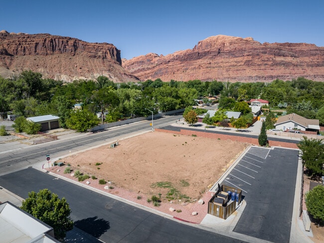

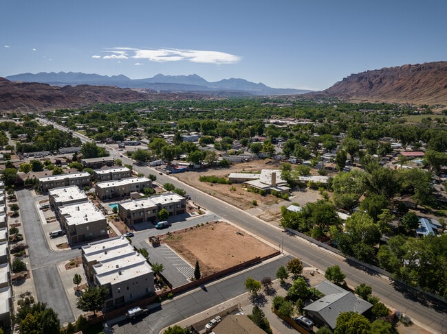
This Property Is For Sale
Property Detail
656 W 400 N
01-0035-0020
BEG AT A POINT WHICH BEARS N 40.1 FT & W 819.3 FT FROM SE COR SEC 35 T25S R21E SLB&M; N 8950'W 140 FT; N 113.8 FT; N 8954'E 1
Vacantlandnec
GRAND
C and X Area of minimal flood hazard, usually depicted on FIRMs as above the 500-year flood level.
Utah
2025
0.37 AC
2025
Moab
000200
Other Market Areas
NEARBY LISTINGS FOR SALE OR LEASE
DEMOGRAPHICS near 656 W 400 N
1 mile
3 mile
5 mile
2025 Total Population
2,515
5,772
7,394
2030 Population
2,455
5,705
7,408
Pop Growth 2025-2030
(2.39%)
(1.16%)
+ 0.19%
Average Age
39
39
41
2025 Total Households
1,010
2,388
3,075
HH Growth 2025-2030
(2.38%)
(1.01%)
+ 0.36%
Median Household Inc
$55,000
$54,169
$59,345
Avg Household Size
2.50
2.40
2.40
2025 Avg HH Vehicles
2.00
2.00
2.00
Median Home Value
$562,684
$567,791
$585,915
Median Year Built
1980
1978
1985
Nearby Places
Map Layers
Map Styles
 Street
 Aerial
Layers
 Traffic
 Biking
Places
Listings with unknown addresses are not visible on the map
- Restaurants
- Banks
- Shops
- Fitness
- Groceries
Nearby Properties
Address
Land Use
TOTAL SIZE
Lot Size
Zoning
Address
Land Use
TOTAL SIZE
Lot Size
Zoning
5.23 AC
Address
Land Use
TOTAL SIZE
Lot Size
Zoning
33.88 AC
Address
Land Use
TOTAL SIZE
Lot Size
Zoning
62,319 SF
4.85 AC
Address
Land Use
TOTAL SIZE
Lot Size
Zoning
68,110 SF
1.38 AC
Address
Land Use
TOTAL SIZE
Lot Size
Zoning
78,548 SF
1.26 AC
Address
Land Use
TOTAL SIZE
Lot Size
Zoning
8,500 SF
21.32 AC
Address
Land Use
TOTAL SIZE
Lot Size
Zoning
59,086 SF
2.65 AC
Address
Land Use
TOTAL SIZE
Lot Size
Zoning
59,032 SF
5 AC
Address
Land Use
TOTAL SIZE
Lot Size
Zoning
1,391 SF
9.40 AC
Address
Land Use
TOTAL SIZE
Lot Size
Zoning
5,875 SF
2.25 AC
Address
Land Use
TOTAL SIZE
Lot Size
Zoning
2,205 SF
39.56 AC
Address
Land Use
TOTAL SIZE
Lot Size
Zoning
58,355 SF
2.58 AC
Address
Land Use
TOTAL SIZE
Lot Size
Zoning
72,946 SF
3.34 AC
Address
Land Use
TOTAL SIZE
Lot Size
Zoning
2,863 SF
4.73 AC
Address
Land Use
TOTAL SIZE
Lot Size
Zoning
51,056 SF
3.04 AC
Address
Land Use
TOTAL SIZE
Lot Size
Zoning
57,094 SF
2.44 AC
Address
Land Use
TOTAL SIZE
Lot Size
Zoning
56,316 SF
1.85 AC
Address
Land Use
TOTAL SIZE
Lot Size
Zoning
1,016 SF
2.67 AC
Address
Land Use
TOTAL SIZE
Lot Size
Zoning
546 SF
6.33 AC
Address
Land Use
TOTAL SIZE
Lot Size
Zoning
0.63 AC
Address
Land Use
TOTAL SIZE
Lot Size
Zoning
7.02 AC
Address
Land Use
TOTAL SIZE
Lot Size
Zoning
32,623 SF
1.49 AC
Address
Land Use
TOTAL SIZE
Lot Size
Zoning
51,005 SF
4.58 AC
Address
Land Use
TOTAL SIZE
Lot Size
Zoning
0.77 AC
Address
Land Use
TOTAL SIZE
Lot Size
Zoning
24,593 SF
1.63 AC
Address
Land Use
TOTAL SIZE
Lot Size
Zoning
6,796 SF
1.31 AC
Address
Land Use
TOTAL SIZE
Lot Size
Zoning
0.03 AC
Address
Land Use
TOTAL SIZE
Lot Size
Zoning
44,491 SF
2.59 AC
Address
Land Use
TOTAL SIZE
Lot Size
Zoning
7,338 SF
0.92 AC
Address
Land Use
TOTAL SIZE
Lot Size
Zoning
3,862 SF
3.10 AC
The World's #1 Commercial Real Estate Marketplace
Connect with us
© 2026 CoStar Group
The information above has been obtained from sources believed reliable. While we do not doubt its accuracy we have not verified it and make no guarantee, warranty or representation about it. It is your responsibility to independently confirm its accuracy and completeness. Any projections, opinions, assumptions, or estimates used are for example only and do not represent the current or future performance of the property. The value of this transaction to you depends on tax and other factors which should be evaluated by your tax, financial, and legal advisors. You and your advisors should conduct a careful, independent investigation of the property to determine to your satisfaction the suitability of the property for your needs.