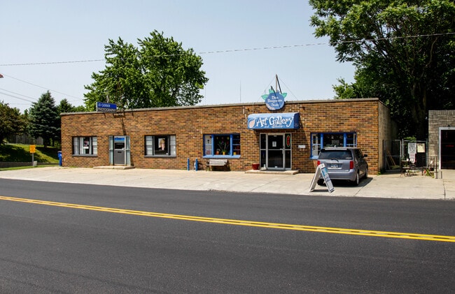
Property Record
6570 Maple St, Omaha, NE 68104

NEARBY LISTINGS FOR SALE OR LEASE
Property Detail
6570 Maple St
Omaha-Council Bluffs, NE-IA
Benson
1667-0000-06
BENSON LOT 14 BLOCK 25 S 1/2 LT 13 & W 40 FT S 1/2
Storebuilding
Douglas
X
Nebraska
31055C0217H
14,13
2024
0.13 AC
2025
Northeast Omaha
005700
Omaha/Council Bluffs
5,400 SF
DEMOGRAPHICS near 6570 Maple St
1 Mile
3 Mile
5 Mile
2024 Total Population
17,114
125,054
278,203
2029 Population
17,323
127,026
283,139
Pop Growth 2024-2029
+ 1.22%
+ 1.58%
+ 1.77%
Average Age
37
37
37
2024 Total Households
7,274
51,822
116,287
HH Growth 2024-2029
+ 1.25%
+ 1.64%
+ 1.89%
Median Household Inc
$55,899
$55,710
$56,125
Avg Household Size
2.30
2.30
2.30
2024 Avg HH Vehicles
2.00
2.00
2.00
Median Home Value
$153,776
$174,888
$181,211
Median Year Built
1953
1960
1964
Nearby Places
Map Layers
Map Styles
 Street
 Aerial
- Restaurants
- Banks
- Shops
- Fitness
- Groceries
PUBLIC TRANSPORTATION
AIRPORT
Eppley Airfield
DRIVE
WALK
Distance
Eppley Airfield
20 min
8.5 mi
SALE & LEASE HISTORY
LISTING DATE
SALE/LEASE

Sep 25, 2016
For Lease
Apr 09, 2018
For Lease
Nearby Properties
Address
Land Use
TOTAL SIZE
Lot Size
Zoning
Address
Land Use
TOTAL SIZE
Lot Size
Zoning
370,431 SF
8.57 AC
Address
Land Use
TOTAL SIZE
Lot Size
Zoning
702,563 SF
18.85 AC
Address
Land Use
TOTAL SIZE
Lot Size
Zoning
687,804 SF
23.14 AC
Address
Land Use
TOTAL SIZE
Lot Size
Zoning
304,034 SF
5.11 AC
R7
Address
Land Use
TOTAL SIZE
Lot Size
Zoning
282,688 SF
18.71 AC
Address
Land Use
TOTAL SIZE
Lot Size
Zoning
256,558 SF
7 AC
GI
Address
Land Use
TOTAL SIZE
Lot Size
Zoning
255,205 SF
9.41 AC
R6
Address
Land Use
TOTAL SIZE
Lot Size
Zoning
249,902 SF
13.02 AC
CC
Address
Land Use
TOTAL SIZE
Lot Size
Zoning
248,169 SF
10.39 AC
Address
Land Use
TOTAL SIZE
Lot Size
Zoning
245,926 SF
8.80 AC
Address
Land Use
TOTAL SIZE
Lot Size
Zoning
231,890 SF
7.81 AC
Address
Land Use
TOTAL SIZE
Lot Size
Zoning
125,945 SF
Address
Land Use
TOTAL SIZE
Lot Size
Zoning
103,227 SF
8.41 AC
Address
Land Use
TOTAL SIZE
Lot Size
Zoning
199,734 SF
3.10 AC
Address
Land Use
TOTAL SIZE
Lot Size
Zoning
229,992 SF
7.17 AC
Address
Land Use
TOTAL SIZE
Lot Size
Zoning
216,667 SF
8.13 AC
Address
Land Use
TOTAL SIZE
Lot Size
Zoning
139,930 SF
1.34 AC
Address
Land Use
TOTAL SIZE
Lot Size
Zoning
148,404 SF
7.77 AC
GO
Address
Land Use
TOTAL SIZE
Lot Size
Zoning
173,179 SF
3.05 AC
Address
Land Use
TOTAL SIZE
Lot Size
Zoning
208,262 SF
5 AC
LO
Address
Land Use
TOTAL SIZE
Lot Size
Zoning
291,270 SF
6.77 AC
Address
Land Use
TOTAL SIZE
Lot Size
Zoning
185,179 SF
2.64 AC
Address
Land Use
TOTAL SIZE
Lot Size
Zoning
172,716 SF
10.16 AC
R6
Address
Land Use
TOTAL SIZE
Lot Size
Zoning
179,012 SF
1.33 AC
Address
Land Use
TOTAL SIZE
Lot Size
Zoning
107,631 SF
3.87 AC
Address
Land Use
TOTAL SIZE
Lot Size
Zoning
184,698 SF
11.10 AC
R6
Address
Land Use
TOTAL SIZE
Lot Size
Zoning
240,320 SF
2.11 AC
Address
Land Use
TOTAL SIZE
Lot Size
Zoning
244,112 SF
4.72 AC
R7
Address
Land Use
TOTAL SIZE
Lot Size
Zoning
105,484 SF
7.89 AC
Address
Land Use
TOTAL SIZE
Lot Size
Zoning
263,314 SF
4.58 AC
R8
The World's #1 Commercial Real Estate Marketplace
Connect with us
© 2025 CoStar Group
The information above has been obtained from sources believed reliable. While we do not doubt its accuracy we have not verified it and make no guarantee, warranty or representation about it. It is your responsibility to independently confirm its accuracy and completeness. Any projections, opinions, assumptions, or estimates used are for example only and do not represent the current or future performance of the property. The value of this transaction to you depends on tax and other factors which should be evaluated by your tax, financial, and legal advisors. You and your advisors should conduct a careful, independent investigation of the property to determine to your satisfaction the suitability of the property for your needs.