Property Record
6570 Trenton Rd, Forestville, CA 95436

NEARBY LISTINGS FOR SALE OR LEASE
-
-
View all Forestville listings for sale on LoopNet.com
Property Detail
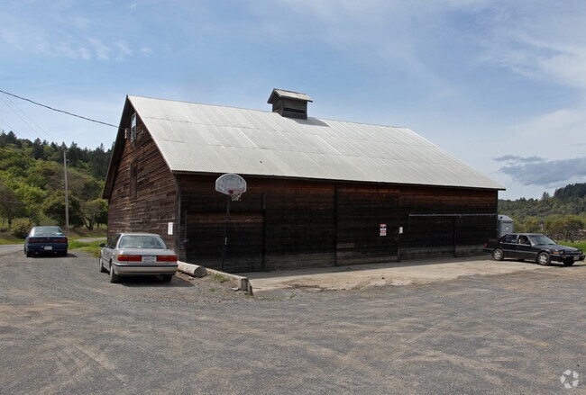
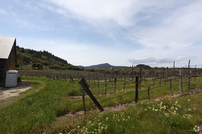
6570 Trenton Rd
Santa Rosa-Petaluma, CA
Molino Rancho
078-020-060
UNINCORP COUNTY CA
Vineyard
Sonoma
AE
California
06097C0705E
9-11
2024
39.16 AC
2025
Sebastopol/Bodega/West
153705
North Bay/Santa Rosa
1,496 SF
DEMOGRAPHICS near 6570 Trenton Rd
1 mile
3 mile
5 mile
2024 Total Population
304
5,276
21,860
2029 Population
291
5,019
21,161
Pop Growth 2024-2029
(4.28%)
(4.87%)
(3.20%)
Average Age
49
48
45
2024 Total Households
124
2,195
8,339
HH Growth 2024-2029
(4.03%)
(4.87%)
(3.31%)
Median Household Inc
$113,194
$105,320
$113,363
Avg Household Size
2.40
2.30
2.50
2024 Avg HH Vehicles
2.00
2.00
2.00
Median Home Value
$841,345
$811,677
$764,823
Median Year Built
1969
1966
1976
Nearby Places
Map Layers
Map Styles
 Street
 Aerial
Transit
 Traffic
 Biking
Places
Listings with unknown addresses are not visible on the map
- Restaurants
- Banks
- Shops
- Fitness
- Groceries
PUBLIC TRANSPORTATION
COMMUTER RAIL
Sonoma County Airport Smart (Main Line - Sonoma Marin Area Rail Transit)
Drive
Walk
Distance
Sonoma County Airport Smart (Main Line - Sonoma Marin Area Rail Transit)
15 min
7.5 mi
Santa Rosa North Smart (Main Line - Sonoma Marin Area Rail Transit)
Drive
Walk
Distance
Santa Rosa North Smart (Main Line - Sonoma Marin Area Rail Transit)
17 min
9.9 mi
AIRPORT
Charles M Schulz - Sonoma County
Drive
Walk
Distance
Charles M Schulz - Sonoma County
16 min
6.5 mi
Freight Ports
Port of Richmond
Drive
Walk
Distance
Port of Richmond
79 min
59.0 mi
Nearby Properties
Address
Land Use
TOTAL SIZE
Lot Size
Zoning
Address
Land Use
TOTAL SIZE
Lot Size
Zoning
46,737 SF
0.12 AC
DA60
Address
Land Use
TOTAL SIZE
Lot Size
Zoning
30.04 AC
Address
Land Use
TOTAL SIZE
Lot Size
Zoning
90,449 SF
12.51 AC
DA20
Address
Land Use
TOTAL SIZE
Lot Size
Zoning
146,448 SF
84.59 AC
Address
Land Use
TOTAL SIZE
Lot Size
Zoning
14,962 SF
20.02 AC
Address
Land Use
TOTAL SIZE
Lot Size
Zoning
0.25 AC
LIA60
Address
Land Use
TOTAL SIZE
Lot Size
Zoning
15,018 SF
34.19 AC
LIA60
Address
Land Use
TOTAL SIZE
Lot Size
Zoning
29,597 SF
96.67 AC
Address
Land Use
TOTAL SIZE
Lot Size
Zoning
360 SF
14 AC
RRD160
Address
Land Use
TOTAL SIZE
Lot Size
Zoning
27,490 SF
21.03 AC
Address
Land Use
TOTAL SIZE
Lot Size
Zoning
21,971 SF
9 AC
Address
Land Use
TOTAL SIZE
Lot Size
Zoning
3,672 SF
16.30 AC
LIA40
Address
Land Use
TOTAL SIZE
Lot Size
Zoning
20,284 SF
24.43 AC
Address
Land Use
TOTAL SIZE
Lot Size
Zoning
13,800 SF
12.17 AC
LIA40
Address
Land Use
TOTAL SIZE
Lot Size
Zoning
6,280 SF
20.09 AC
DA20
Address
Land Use
TOTAL SIZE
Lot Size
Zoning
4,028 SF
26.57 AC
LEA100
Address
Land Use
TOTAL SIZE
Lot Size
Zoning
9,127 SF
262.94 AC
LEAB7FRZN
Address
Land Use
TOTAL SIZE
Lot Size
Zoning
16,535 SF
17.95 AC
Address
Land Use
TOTAL SIZE
Lot Size
Zoning
7,615 SF
34.30 AC
LIA60
Address
Land Use
TOTAL SIZE
Lot Size
Zoning
43.67 AC
Address
Land Use
TOTAL SIZE
Lot Size
Zoning
14,589 SF
7.13 AC
LIA60
Address
Land Use
TOTAL SIZE
Lot Size
Zoning
45,172 SF
93.59 AC
Address
Land Use
TOTAL SIZE
Lot Size
Zoning
70,673 SF
3.50 AC
Address
Land Use
TOTAL SIZE
Lot Size
Zoning
84,504 SF
8.55 AC
LCF2
Address
Land Use
TOTAL SIZE
Lot Size
Zoning
1,500 SF
69 AC
LIA40
Address
Land Use
TOTAL SIZE
Lot Size
Zoning
4,960 SF
30 AC
DA60
Address
Land Use
TOTAL SIZE
Lot Size
Zoning
2,616 SF
53.85 AC
LEA100
Address
Land Use
TOTAL SIZE
Lot Size
Zoning
8,881 SF
10 AC
Address
Land Use
TOTAL SIZE
Lot Size
Zoning
10,082 SF
17.42 AC
DA10
Address
Land Use
TOTAL SIZE
Lot Size
Zoning
19,562 SF
6.69 AC
The World's #1 Commercial Real Estate Marketplace
Connect with us
© 2026 CoStar Group
The information above has been obtained from sources believed reliable. While we do not doubt its accuracy we have not verified it and make no guarantee, warranty or representation about it. It is your responsibility to independently confirm its accuracy and completeness. Any projections, opinions, assumptions, or estimates used are for example only and do not represent the current or future performance of the property. The value of this transaction to you depends on tax and other factors which should be evaluated by your tax, financial, and legal advisors. You and your advisors should conduct a careful, independent investigation of the property to determine to your satisfaction the suitability of the property for your needs.