Property Record
66 Ampad Rd, Westfield, MA 01085
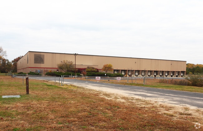

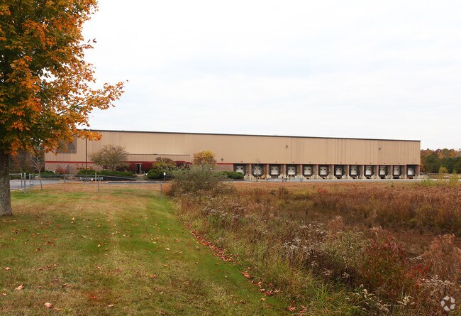
Property Detail
66 Ampad Rd
WFLD-000056-R000000-000001
Hampden
Commercialnec
Massachusetts
B and X Area of moderate flood hazard, usually the area between the limits of the 100-year and 500-year floods.
1
2024
41.06 AC
2025
Hampden County
812800
Hartford
105,408 SF
Springfield, MA
NEARBY LISTINGS FOR SALE OR LEASE
DEMOGRAPHICS near 66 Ampad Rd
1 mile
3 mile
5 mile
2025 Total Population
2,019
21,747
45,884
2030 Population
2,046
21,786
45,887
Pop Growth 2025-2030
+ 1.34%
+ 0.18%
+ 0.01%
Average Age
47
41
42
2025 Total Households
816
8,611
17,828
HH Growth 2025-2030
+ 1.35%
+ 0.10%
(0.06%)
Median Household Inc
$81,510
$71,514
$86,677
Avg Household Size
2.30
2.30
2.40
2025 Avg HH Vehicles
2.00
2.00
2.00
Median Home Value
$324,285
$306,828
$342,792
Median Year Built
1982
1963
1966
Nearby Places
Map Layers
Map Styles
 Street
 Aerial
Layers
 Traffic
 Biking
Places
Listings with unknown addresses are not visible on the map
- Restaurants
- Banks
- Shops
- Fitness
- Groceries
PUBLIC TRANSPORTATION
AIRPORT
Bradley International
Drive
Walk
Distance
Bradley International
49 min
21.8 mi
Freight Ports
Port of New Haven
Drive
Walk
Distance
Port of New Haven
106 min
78.0 mi
Nearby Properties
Address
Land Use
TOTAL SIZE
Lot Size
Zoning
Address
Land Use
TOTAL SIZE
Lot Size
Zoning
71.67 AC
Address
Land Use
TOTAL SIZE
Lot Size
Zoning
133.29 AC
Address
Land Use
TOTAL SIZE
Lot Size
Zoning
Address
Land Use
TOTAL SIZE
Lot Size
Zoning
3.80 AC
Address
Land Use
TOTAL SIZE
Lot Size
Zoning
Address
Land Use
TOTAL SIZE
Lot Size
Zoning
74.25 AC
Address
Land Use
TOTAL SIZE
Lot Size
Zoning
143,568 SF
14.69 AC
Address
Land Use
TOTAL SIZE
Lot Size
Zoning
264,759 SF
51.70 AC
Address
Land Use
TOTAL SIZE
Lot Size
Zoning
99,230 SF
10.94 AC
Address
Land Use
TOTAL SIZE
Lot Size
Zoning
Address
Land Use
TOTAL SIZE
Lot Size
Zoning
215,179 SF
9.83 AC
Address
Land Use
TOTAL SIZE
Lot Size
Zoning
293,814 SF
32.68 AC
Address
Land Use
TOTAL SIZE
Lot Size
Zoning
64,414 SF
6.62 AC
Address
Land Use
TOTAL SIZE
Lot Size
Zoning
28.81 AC
Address
Land Use
TOTAL SIZE
Lot Size
Zoning
17,428 SF
15.80 AC
Address
Land Use
TOTAL SIZE
Lot Size
Zoning
242,152 SF
18.76 AC
Address
Land Use
TOTAL SIZE
Lot Size
Zoning
Address
Land Use
TOTAL SIZE
Lot Size
Zoning
9.99 AC
Address
Land Use
TOTAL SIZE
Lot Size
Zoning
50,911 SF
3.31 AC
Address
Land Use
TOTAL SIZE
Lot Size
Zoning
43,050 SF
11.60 AC
Address
Land Use
TOTAL SIZE
Lot Size
Zoning
Address
Land Use
TOTAL SIZE
Lot Size
Zoning
42.70 AC
Address
Land Use
TOTAL SIZE
Lot Size
Zoning
275,103 SF
23.28 AC
Address
Land Use
TOTAL SIZE
Lot Size
Zoning
21,405 SF
0.01 AC
Address
Land Use
TOTAL SIZE
Lot Size
Zoning
6.80 AC
Address
Land Use
TOTAL SIZE
Lot Size
Zoning
100,908 SF
1.84 AC
Address
Land Use
TOTAL SIZE
Lot Size
Zoning
97,311 SF
5.11 AC
Address
Land Use
TOTAL SIZE
Lot Size
Zoning
86,524 SF
12.40 AC
Address
Land Use
TOTAL SIZE
Lot Size
Zoning
26.09 AC
The World's #1 Commercial Real Estate Marketplace
Connect with us
© 2026 CoStar Group
The information above has been obtained from sources believed reliable. While we do not doubt its accuracy we have not verified it and make no guarantee, warranty or representation about it. It is your responsibility to independently confirm its accuracy and completeness. Any projections, opinions, assumptions, or estimates used are for example only and do not represent the current or future performance of the property. The value of this transaction to you depends on tax and other factors which should be evaluated by your tax, financial, and legal advisors. You and your advisors should conduct a careful, independent investigation of the property to determine to your satisfaction the suitability of the property for your needs.