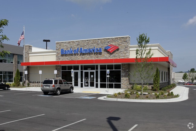
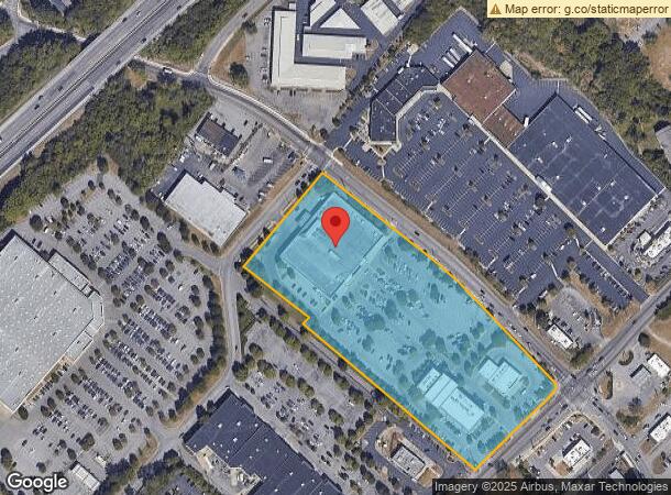
Property Record
6604 Charlotte Pike, Nashville, TN 37209

NEARBY LISTINGS FOR SALE OR LEASE
Property Detail
6604 Charlotte Pike
Nashville-Davidson--Murfreesboro--Franklin, TN
Subdivision Of Mount Hickory
102-00-0-033
PT. LOT 1 MT. HICKORY AND ACREAGE TRACT
Supermarket
Davidson
X
Tennessee
47037C0219H
1
2025
7.54 AC
2025
Bellevue/W Nashville
018101
Nashville
47,263 SF
DEMOGRAPHICS near 6604 Charlotte Pike
1 Mile
3 Mile
5 Mile
2024 Total Population
7,488
46,074
136,192
2029 Population
7,415
45,897
136,333
Pop Growth 2024-2029
(0.97%)
(0.38%)
+ 0.10%
Average Age
38
38
37
2024 Total Households
3,078
21,079
60,173
HH Growth 2024-2029
(1.27%)
(0.69%)
(0.01%)
Median Household Inc
$64,000
$85,927
$73,159
Avg Household Size
2.30
2.10
2.00
2024 Avg HH Vehicles
2.00
2.00
2.00
Median Home Value
$383,959
$564,185
$596,271
Median Year Built
1969
1978
1986
Nearby Places
Map Layers
Map Styles
 Street
 Aerial
- Restaurants
- Banks
- Shops
- Fitness
- Groceries
PUBLIC TRANSPORTATION
COMMUTER RAIL
Riverfront (East Corridor Line - Tennessee Regional Transportation Authority Music City Star (Music City Star))
DRIVE
WALK
Distance
Riverfront (East Corridor Line - Tennessee Regional Transportation Authority Music City Star (Music City Star))
13 min
7.8 mi
AIRPORT
Nashville International
DRIVE
WALK
Distance
Nashville International
25 min
16.6 mi
Nearby Properties
Address
Land Use
TOTAL SIZE
Lot Size
Zoning
Address
Land Use
TOTAL SIZE
Lot Size
Zoning
76,787 SF
3.86 AC
3ZZ
Address
Land Use
TOTAL SIZE
Lot Size
Zoning
184,700 SF
14.20 AC
RM40
Address
Land Use
TOTAL SIZE
Lot Size
Zoning
301.19 AC
MULTI-ZONE
Address
Land Use
TOTAL SIZE
Lot Size
Zoning
80,280 SF
2.20 AC
OVUDO
Address
Land Use
TOTAL SIZE
Lot Size
Zoning
70,428 SF
16.99 AC
CS
Address
Land Use
TOTAL SIZE
Lot Size
Zoning
121,769 SF
4.64 AC
MULTI-ZONE
Address
Land Use
TOTAL SIZE
Lot Size
Zoning
91.99 AC
R8
Address
Land Use
TOTAL SIZE
Lot Size
Zoning
20,496 SF
41.24 AC
RM20
Address
Land Use
TOTAL SIZE
Lot Size
Zoning
33,572 SF
70.08 AC
MULTI-ZONE
Address
Land Use
TOTAL SIZE
Lot Size
Zoning
154,530 SF
6.18 AC
SP
Address
Land Use
TOTAL SIZE
Lot Size
Zoning
80.71 AC
R6
Address
Land Use
TOTAL SIZE
Lot Size
Zoning
44,858 SF
10.11 AC
MUL
Address
Land Use
TOTAL SIZE
Lot Size
Zoning
82,563 SF
14.44 AC
MULTIZONE
Address
Land Use
TOTAL SIZE
Lot Size
Zoning
81,996 SF
9.30 AC
3ZZ
Address
Land Use
TOTAL SIZE
Lot Size
Zoning
89,821 SF
3.90 AC
IR
Address
Land Use
TOTAL SIZE
Lot Size
Zoning
146.13 AC
IR
Address
Land Use
TOTAL SIZE
Lot Size
Zoning
234,840 SF
3.25 AC
MULTIZONE
Address
Land Use
TOTAL SIZE
Lot Size
Zoning
2,768 SF
16.64 AC
RM9
Address
Land Use
TOTAL SIZE
Lot Size
Zoning
15,045 SF
7.10 AC
IR
Address
Land Use
TOTAL SIZE
Lot Size
Zoning
32,079 SF
43.70 AC
RM4
Address
Land Use
TOTAL SIZE
Lot Size
Zoning
146,453 SF
3.42 AC
IR
Address
Land Use
TOTAL SIZE
Lot Size
Zoning
94,354 SF
10.01 AC
CS
Address
Land Use
TOTAL SIZE
Lot Size
Zoning
6,160 SF
12.53 AC
MULTI-ZONE
Address
Land Use
TOTAL SIZE
Lot Size
Zoning
76,395 SF
5.10 AC
MULA
Address
Land Use
TOTAL SIZE
Lot Size
Zoning
36,276 SF
9.58 AC
SCC
Address
Land Use
TOTAL SIZE
Lot Size
Zoning
202.73 AC
R6
Address
Land Use
TOTAL SIZE
Lot Size
Zoning
11,180 SF
3.06 AC
RS7.5
Address
Land Use
TOTAL SIZE
Lot Size
Zoning
52,769 SF
14.38 AC
SCR
Address
Land Use
TOTAL SIZE
Lot Size
Zoning
43,470 SF
15.97 AC
OR20
Address
Land Use
TOTAL SIZE
Lot Size
Zoning
20,160 SF
15.30 AC
RM20
The World's #1 Commercial Real Estate Marketplace
Connect with us
© 2026 CoStar Group
The information above has been obtained from sources believed reliable. While we do not doubt its accuracy we have not verified it and make no guarantee, warranty or representation about it. It is your responsibility to independently confirm its accuracy and completeness. Any projections, opinions, assumptions, or estimates used are for example only and do not represent the current or future performance of the property. The value of this transaction to you depends on tax and other factors which should be evaluated by your tax, financial, and legal advisors. You and your advisors should conduct a careful, independent investigation of the property to determine to your satisfaction the suitability of the property for your needs.