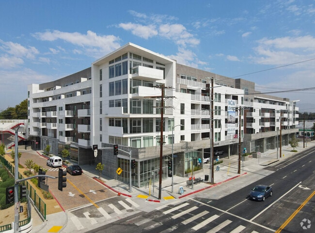
Property Record
6611 Reseda Blvd, Reseda, CA 91335
Current Lease Availabilities
NEARBY LISTINGS FOR SALE OR LEASE
Property Detail
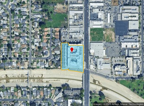
6611 Reseda Blvd
Los Angeles-Long Beach-Glendale, CA
Parcel Map L. A. No. 20141758
2126-038-045
PM 395-65-66 LOT A
Retailwithmorethanonenonretailuse
Los Angeles
A
California
06037C1285F
a
2024
2.52 AC
2025
Reseda
131024
Los Angeles
257,873 SF
DEMOGRAPHICS near 6611 Reseda Blvd
1 mile
3 mile
5 mile
2024 Total Population
36,098
225,377
561,277
2029 Population
35,022
218,983
548,133
Pop Growth 2024-2029
(2.98%)
(2.84%)
(2.34%)
Average Age
40
41
40
2024 Total Households
11,881
76,837
195,826
HH Growth 2024-2029
(3.32%)
(3.07%)
(2.49%)
Median Household Inc
$66,590
$78,145
$78,854
Avg Household Size
2.90
2.80
2.80
2024 Avg HH Vehicles
2.00
2.00
2.00
Median Home Value
$708,380
$768,987
$785,594
Median Year Built
1969
1966
1970
Nearby Places
Map Layers
Map Styles
 Street
 Aerial
Transit
 Traffic
 Biking
Places
Listings with unknown addresses are not visible on the map
- Restaurants
- Banks
- Shops
- Fitness
- Groceries
PUBLIC TRANSPORTATION
TRANSIT/SUBWAY
Reseda Station (Orange Line - Los Angeles County Metropolitan Transportation Authority (Metro))
Drive
Walk
Distance
Reseda Station (Orange Line - Los Angeles County Metropolitan Transportation Authority (Metro))
2 min
15 min
0.8 mi
COMMUTER RAIL
Northridge (Ventura County Line - Southern California Regional Rail Authority (Metrolink))
Drive
Walk
Distance
Northridge (Ventura County Line - Southern California Regional Rail Authority (Metrolink))
11 min
3.4 mi
Van Nuys (Ventura County Line - Southern California Regional Rail Authority (Metrolink))
Drive
Walk
Distance
Van Nuys (Ventura County Line - Southern California Regional Rail Authority (Metrolink))
20 min
6.9 mi
AIRPORT
Bob Hope
Drive
Walk
Distance
Bob Hope
25 min
15.2 mi
Los Angeles International
Drive
Walk
Distance
Los Angeles International
32 min
27.1 mi
Freight Ports
Port of Los Angeles
Drive
Walk
Distance
Port of Los Angeles
1 min
35.2 mi
Nearby Properties
Address
Land Use
TOTAL SIZE
Lot Size
Zoning
Address
Land Use
TOTAL SIZE
Lot Size
Zoning
461,531 SF
11.22 AC
LAC2
Address
Land Use
TOTAL SIZE
Lot Size
Zoning
300,266 SF
7.29 AC
LAR4
Address
Land Use
TOTAL SIZE
Lot Size
Zoning
546,652 SF
4.27 AC
LAC2
Address
Land Use
TOTAL SIZE
Lot Size
Zoning
595,008 SF
18.57 AC
LAC1
Address
Land Use
TOTAL SIZE
Lot Size
Zoning
191,058 SF
5.31 AC
LAR3
Address
Land Use
TOTAL SIZE
Lot Size
Zoning
273,911 SF
8.40 AC
LARA
Address
Land Use
TOTAL SIZE
Lot Size
Zoning
318,083 SF
2.36 AC
LAC2
Address
Land Use
TOTAL SIZE
Lot Size
Zoning
219,126 SF
6.06 AC
LAR1
Address
Land Use
TOTAL SIZE
Lot Size
Zoning
111,876 SF
3.72 AC
LAC2
Address
Land Use
TOTAL SIZE
Lot Size
Zoning
210,268 SF
3.82 AC
LAP
Address
Land Use
TOTAL SIZE
Lot Size
Zoning
117,604 SF
2.65 AC
LAR3
Address
Land Use
TOTAL SIZE
Lot Size
Zoning
173,231 SF
1.58 AC
LAR3
Address
Land Use
TOTAL SIZE
Lot Size
Zoning
250,462 SF
1.85 AC
LAP
Address
Land Use
TOTAL SIZE
Lot Size
Zoning
95,584 SF
4.27 AC
LAM1
Address
Land Use
TOTAL SIZE
Lot Size
Zoning
134,103 SF
1 AC
LAC2
Address
Land Use
TOTAL SIZE
Lot Size
Zoning
146,790 SF
1.85 AC
LAR3
Address
Land Use
TOTAL SIZE
Lot Size
Zoning
232,912 SF
5.35 AC
LAC1
Address
Land Use
TOTAL SIZE
Lot Size
Zoning
76,248 SF
1.21 AC
LAR3
Address
Land Use
TOTAL SIZE
Lot Size
Zoning
67,933 SF
0.93 AC
LAC2
Address
Land Use
TOTAL SIZE
Lot Size
Zoning
67,102 SF
1.72 AC
LAC4
Address
Land Use
TOTAL SIZE
Lot Size
Zoning
84,864 SF
2.39 AC
LAR3
Address
Land Use
TOTAL SIZE
Lot Size
Zoning
34,248 SF
1.64 AC
LARD5
Address
Land Use
TOTAL SIZE
Lot Size
Zoning
68,902 SF
1.05 AC
LAC4
Address
Land Use
TOTAL SIZE
Lot Size
Zoning
74,930 SF
2.01 AC
LAR3
Address
Land Use
TOTAL SIZE
Lot Size
Zoning
136,721 SF
3.44 AC
LARA
Address
Land Use
TOTAL SIZE
Lot Size
Zoning
40,729 SF
1.37 AC
LARA
Address
Land Use
TOTAL SIZE
Lot Size
Zoning
54,584 SF
0.69 AC
LACR
Address
Land Use
TOTAL SIZE
Lot Size
Zoning
288,501 SF
4.03 AC
LACR
Address
Land Use
TOTAL SIZE
Lot Size
Zoning
81,888 SF
1.01 AC
LAC2
The World's #1 Commercial Real Estate Marketplace
Connect with us
© 2026 CoStar Group
The information above has been obtained from sources believed reliable. While we do not doubt its accuracy we have not verified it and make no guarantee, warranty or representation about it. It is your responsibility to independently confirm its accuracy and completeness. Any projections, opinions, assumptions, or estimates used are for example only and do not represent the current or future performance of the property. The value of this transaction to you depends on tax and other factors which should be evaluated by your tax, financial, and legal advisors. You and your advisors should conduct a careful, independent investigation of the property to determine to your satisfaction the suitability of the property for your needs.