Property Record
67 Winthrop Rd, Chester, CT 06412
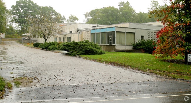

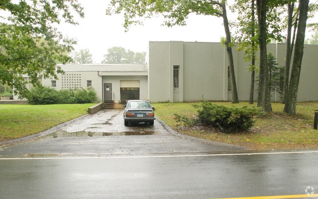
Property Detail
67 Winthrop Rd
Industrialgeneral
MIDDLESEX
RLM
Connecticut
B and X Area of moderate flood hazard, usually the area between the limits of the 100-year and 500-year floods.
4.72 AC
2025
SW Midlsx/Old Saybrk
2025
Hartford
600100
Hartford-West Hartford-East Hartford, CT
27,904 SF
CHES-000017-000000-000023
NEARBY LISTINGS FOR SALE OR LEASE
DEMOGRAPHICS near 67 Winthrop Rd
1 mile
3 mile
5 mile
2025 Total Population
588
4,744
19,286
2030 Population
601
4,799
19,509
Pop Growth 2025-2030
+ 2.21%
+ 1.16%
+ 1.16%
Average Age
50
48
47
2025 Total Households
266
2,035
8,012
HH Growth 2025-2030
+ 1.88%
+ 1.18%
+ 1.14%
Median Household Inc
$103,750
$108,066
$105,131
Avg Household Size
2.10
2.30
2.30
2025 Avg HH Vehicles
2.00
2.00
2.00
Median Home Value
$407,377
$404,442
$416,093
Median Year Built
1974
1973
1973
Nearby Places
Map Layers
Map Styles
 Street
 Aerial
Layers
 Traffic
 Biking
Places
Listings with unknown addresses are not visible on the map
- Restaurants
- Banks
- Shops
- Fitness
- Groceries
PUBLIC TRANSPORTATION
COMMUTER RAIL
Drive
Walk
Distance
17 min
9.7 mi
AIRPORT
Tweed/New Haven
Drive
Walk
Distance
Tweed/New Haven
42 min
28.8 mi
Freight Ports
Port of New Haven
Drive
Walk
Distance
Port of New Haven
42 min
29.4 mi
Nearby Properties
Address
Land Use
TOTAL SIZE
Lot Size
Zoning
Address
Land Use
TOTAL SIZE
Lot Size
Zoning
50,026 SF
12.87 AC
R-1
Address
Land Use
TOTAL SIZE
Lot Size
Zoning
26.29 AC
R-2
Address
Land Use
TOTAL SIZE
Lot Size
Zoning
52,000 SF
17.96 AC
RLM
Address
Land Use
TOTAL SIZE
Lot Size
Zoning
384 AC
R-2
Address
Land Use
TOTAL SIZE
Lot Size
Zoning
595.01 AC
R-2
Address
Land Use
TOTAL SIZE
Lot Size
Zoning
7,152 SF
122.42 AC
RLM
Address
Land Use
TOTAL SIZE
Lot Size
Zoning
7,376 SF
94.68 AC
R-2
Address
Land Use
TOTAL SIZE
Lot Size
Zoning
44.17 AC
R-2
Address
Land Use
TOTAL SIZE
Lot Size
Zoning
63,938 SF
9.79 AC
CDD
Address
Land Use
TOTAL SIZE
Lot Size
Zoning
19.27 AC
R-2
Address
Land Use
TOTAL SIZE
Lot Size
Zoning
50.35 AC
CIP
Address
Land Use
TOTAL SIZE
Lot Size
Zoning
26,148 SF
12.22 AC
R-2
Address
Land Use
TOTAL SIZE
Lot Size
Zoning
2.15 AC
R-1
Address
Land Use
TOTAL SIZE
Lot Size
Zoning
40,600 SF
6.60 AC
CDD
Address
Land Use
TOTAL SIZE
Lot Size
Zoning
39,774 SF
6 AC
CDD
Address
Land Use
TOTAL SIZE
Lot Size
Zoning
0.06 AC
PRD
Address
Land Use
TOTAL SIZE
Lot Size
Zoning
30,480 SF
3.18 AC
RLM
Address
Land Use
TOTAL SIZE
Lot Size
Zoning
20,378 SF
3.50 AC
CIP
Address
Land Use
TOTAL SIZE
Lot Size
Zoning
7,399 SF
3.90 AC
R-1
Address
Land Use
TOTAL SIZE
Lot Size
Zoning
6.77 AC
C
Address
Land Use
TOTAL SIZE
Lot Size
Zoning
2.45 AC
R-1
Address
Land Use
TOTAL SIZE
Lot Size
Zoning
12.45 AC
R80
Address
Land Use
TOTAL SIZE
Lot Size
Zoning
4,000 SF
3.88 AC
CIP
Address
Land Use
TOTAL SIZE
Lot Size
Zoning
76 AC
R-2
Address
Land Use
TOTAL SIZE
Lot Size
Zoning
34.65 AC
C
Address
Land Use
TOTAL SIZE
Lot Size
Zoning
1.01 AC
R-1
Address
Land Use
TOTAL SIZE
Lot Size
Zoning
5,660 SF
1.50 AC
R60
Address
Land Use
TOTAL SIZE
Lot Size
Zoning
16.71 AC
R-2
Address
Land Use
TOTAL SIZE
Lot Size
Zoning
4,000 SF
8.37 AC
CDD
The World's #1 Commercial Real Estate Marketplace
Connect with us
© 2026 CoStar Group
The information above has been obtained from sources believed reliable. While we do not doubt its accuracy we have not verified it and make no guarantee, warranty or representation about it. It is your responsibility to independently confirm its accuracy and completeness. Any projections, opinions, assumptions, or estimates used are for example only and do not represent the current or future performance of the property. The value of this transaction to you depends on tax and other factors which should be evaluated by your tax, financial, and legal advisors. You and your advisors should conduct a careful, independent investigation of the property to determine to your satisfaction the suitability of the property for your needs.