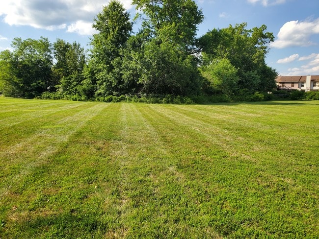
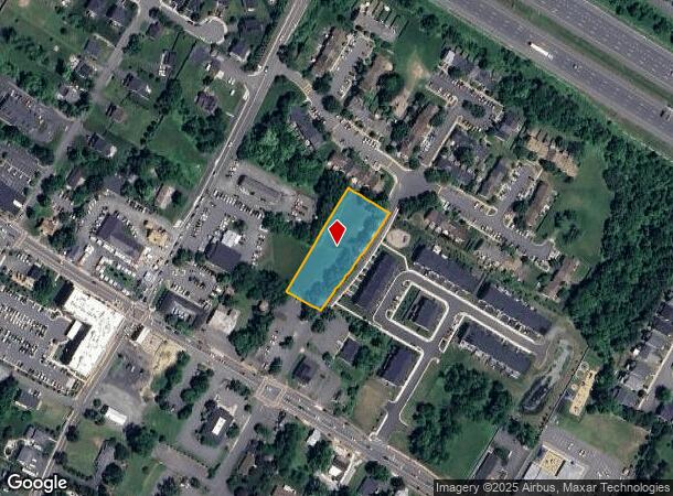
Property Record
6700 Hunting Path Rd, Haymarket, VA 20169
NEARBY LISTINGS FOR SALE OR LEASE
Property Detail
6700 Hunting Path Rd
Washington-Arlington-Alexandria, DC-VA-MD-WV
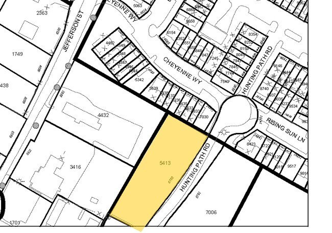
Sarato Div
7298-90-5413
DIV OF SARATO LOT 5
Vacantlandnec
Prince William
X
Virginia
51061C0250D
5413
2024
0.95 AC
2025
Route 29/I-66 Corridor
901511
Washington, DC
DEMOGRAPHICS near 6700 Hunting Path Rd
1 Mile
3 Mile
5 Mile
2024 Total Population
11,965
51,612
77,254
2029 Population
12,290
53,251
79,591
Pop Growth 2024-2029
+ 2.72%
+ 3.18%
+ 3.03%
Average Age
35
40
39
2024 Total Households
3,742
17,294
24,824
HH Growth 2024-2029
+ 2.78%
+ 3.19%
+ 3.09%
Median Household Inc
$137,500
$144,551
$148,306
Avg Household Size
3.10
2.90
3.00
2024 Avg HH Vehicles
2.00
2.00
2.00
Median Home Value
$460,639
$636,435
$643,532
Median Year Built
2004
2005
2004
Nearby Places
Map Layers
Map Styles
 Street
 Aerial
- Restaurants
- Banks
- Shops
- Fitness
- Groceries
PUBLIC TRANSPORTATION
AIRPORT
Washington Dulles International
DRIVE
WALK
Distance
Washington Dulles International
36 min
24.7 mi
Freight Ports
Port of Baltimore
DRIVE
WALK
Distance
Port of Baltimore
95 min
75.1 mi
SALE & LEASE HISTORY
LISTING DATE
SALE/LEASE

Jun 10, 2019
For Sale
Jun 02, 2025
For Lease
Jan 09, 2018
For Sale
Nearby Properties
Address
Land Use
TOTAL SIZE
Lot Size
Zoning
Address
Land Use
TOTAL SIZE
Lot Size
Zoning
482,223 SF
28.10 AC
PBD
Address
Land Use
TOTAL SIZE
Lot Size
Zoning
453,174 SF
38.50 AC
PBD
Address
Land Use
TOTAL SIZE
Lot Size
Zoning
560,942 SF
90.90 AC
B1
Address
Land Use
TOTAL SIZE
Lot Size
Zoning
252,966 SF
10.54 AC
PMD
Address
Land Use
TOTAL SIZE
Lot Size
Zoning
482,200 SF
29.18 AC
PBD
Address
Land Use
TOTAL SIZE
Lot Size
Zoning
220,552 SF
30.95 AC
PMD
Address
Land Use
TOTAL SIZE
Lot Size
Zoning
236,082 SF
28.27 AC
M2
Address
Land Use
TOTAL SIZE
Lot Size
Zoning
298,474 SF
11.60 AC
PMR
Address
Land Use
TOTAL SIZE
Lot Size
Zoning
280,221 SF
78.35 AC
RPC
Address
Land Use
TOTAL SIZE
Lot Size
Zoning
333,737 SF
37.06 AC
RPC
Address
Land Use
TOTAL SIZE
Lot Size
Zoning
28.38 AC
PBD
Address
Land Use
TOTAL SIZE
Lot Size
Zoning
147,877 SF
39.51 AC
MIXED
Address
Land Use
TOTAL SIZE
Lot Size
Zoning
75,317 SF
13.68 AC
R16
Address
Land Use
TOTAL SIZE
Lot Size
Zoning
241,328 SF
8.66 AC
B1
Address
Land Use
TOTAL SIZE
Lot Size
Zoning
23.65 AC
R4
Address
Land Use
TOTAL SIZE
Lot Size
Zoning
92,182 SF
19.90 AC
B1
Address
Land Use
TOTAL SIZE
Lot Size
Zoning
18.22 AC
A1
Address
Land Use
TOTAL SIZE
Lot Size
Zoning
Address
Land Use
TOTAL SIZE
Lot Size
Zoning
140,285 SF
20.51 AC
RPC
Address
Land Use
TOTAL SIZE
Lot Size
Zoning
125,157 SF
18.53 AC
B1
Address
Land Use
TOTAL SIZE
Lot Size
Zoning
285,889 SF
19.61 AC
M1
Address
Land Use
TOTAL SIZE
Lot Size
Zoning
125,653 SF
19.78 AC
MIXED
Address
Land Use
TOTAL SIZE
Lot Size
Zoning
144,869 SF
40.78 AC
A1
Address
Land Use
TOTAL SIZE
Lot Size
Zoning
80,141 SF
8.67 AC
B1
Address
Land Use
TOTAL SIZE
Lot Size
Zoning
107,175 SF
6.96 AC
RPC
Address
Land Use
TOTAL SIZE
Lot Size
Zoning
134,520 SF
11.12 AC
MIXED
Address
Land Use
TOTAL SIZE
Lot Size
Zoning
99,391 SF
24.31 AC
SR1
Address
Land Use
TOTAL SIZE
Lot Size
Zoning
12.40 AC
MIXED
Address
Land Use
TOTAL SIZE
Lot Size
Zoning
102,058 SF
7.07 AC
PBD
Address
Land Use
TOTAL SIZE
Lot Size
Zoning
158,198 SF
7.13 AC
M1
The World's #1 Commercial Real Estate Marketplace
Connect with us
© 2025 CoStar Group
The information above has been obtained from sources believed reliable. While we do not doubt its accuracy we have not verified it and make no guarantee, warranty or representation about it. It is your responsibility to independently confirm its accuracy and completeness. Any projections, opinions, assumptions, or estimates used are for example only and do not represent the current or future performance of the property. The value of this transaction to you depends on tax and other factors which should be evaluated by your tax, financial, and legal advisors. You and your advisors should conduct a careful, independent investigation of the property to determine to your satisfaction the suitability of the property for your needs.