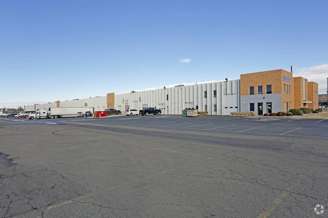
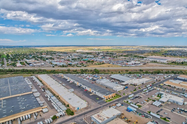
Property Record
6751 E 50Th Ave, Commerce City, CO 80022
Current Lease Availabilities
Property Detail
6751 E 50Th Ave
1823-17-4-00-011
SECT,TWN,RNG:17-3-67 DESC: PARC IN THE N2 SE4 OF SEC 17 DESC AS FOLS BEG AT A PT ON S LN OF SD N2 SE4 OF SEC 17 FROM WHICH PT THE SE COR OF NE4 SE4 OF SD SEC 17 BRS S 89D 56M 00S E 1788/88 FT TH N 00D 16M 42S E 929/19 FT TH N 53D 30M 05S W 247/91 FT
Warehouse
ADAMS
AE The base floodplain where base flood elevations are provided. AE Zones are now used on new format FIRMs instead of A1-A30 Zones.
Colorado
2024
4.43 AC
2025
East I-70/270
008709
Denver
81,888 SF
Denver-Aurora-Centennial, CO
NEARBY LISTINGS FOR SALE OR LEASE
DEMOGRAPHICS near 6751 E 50Th Ave
1 mile
3 mile
5 mile
2024 Total Population
2,840
81,928
298,244
2029 Population
2,899
83,820
306,834
Pop Growth 2024-2029
+ 2.08%
+ 2.31%
+ 2.88%
Average Age
34
37
37
2024 Total Households
913
28,906
119,105
HH Growth 2024-2029
+ 2.52%
+ 2.25%
+ 3.04%
Median Household Inc
$101,934
$108,604
$93,660
Avg Household Size
2.90
2.70
2.40
2024 Avg HH Vehicles
2.00
2.00
2.00
Median Home Value
$591,270
$670,043
$630,601
Median Year Built
2008
1977
1973
Nearby Places
Map Layers
Map Styles
 Street
 Aerial
Transit
 Traffic
 Biking
Places
Listings with unknown addresses are not visible on the map
- Restaurants
- Banks
- Shops
- Fitness
- Groceries
PUBLIC TRANSPORTATION
COMMUTER RAIL
Central Park Station Track 1 (Union Station to Denver Airport Station - Regional Transportation District)
Drive
Walk
Distance
Central Park Station Track 1 (Union Station to Denver Airport Station - Regional Transportation District)
7 min
2.5 mi
Central Park Station Track 2 (Union Station to Denver Airport Station - Regional Transportation District)
Drive
Walk
Distance
Central Park Station Track 2 (Union Station to Denver Airport Station - Regional Transportation District)
7 min
2.5 mi
AIRPORT
Denver International
Drive
Walk
Distance
Denver International
26 min
18.7 mi
Freight Ports
Tulsa Port Of Catoosa
Drive
Walk
Distance
Tulsa Port Of Catoosa
723 min
704.2 mi
Nearby Properties
Address
Land Use
TOTAL SIZE
Lot Size
Zoning
Address
Land Use
TOTAL SIZE
Lot Size
Zoning
677,018 SF
5.05 AC
C-MX
Address
Land Use
TOTAL SIZE
Lot Size
Zoning
719,357 SF
21.47 AC
M-MX-5
Address
Land Use
TOTAL SIZE
Lot Size
Zoning
343,997 SF
6.36 AC
S-MX-5
Address
Land Use
TOTAL SIZE
Lot Size
Zoning
256,155 SF
3.84 AC
Address
Land Use
TOTAL SIZE
Lot Size
Zoning
169,941 SF
4.08 AC
I-B
Address
Land Use
TOTAL SIZE
Lot Size
Zoning
723,053 SF
32.44 AC
M-IMX-12
Address
Land Use
TOTAL SIZE
Lot Size
Zoning
269,025 SF
18.86 AC
M-RX-5
Address
Land Use
TOTAL SIZE
Lot Size
Zoning
17,063 SF
2.01 AC
Address
Land Use
TOTAL SIZE
Lot Size
Zoning
45,803 SF
1.96 AC
M-IMX-5
Address
Land Use
TOTAL SIZE
Lot Size
Zoning
254,509 SF
16.29 AC
E-SU-DX
Address
Land Use
TOTAL SIZE
Lot Size
Zoning
97,306 SF
4.25 AC
C-MX
Address
Land Use
TOTAL SIZE
Lot Size
Zoning
3,573.99 AC
A3
Address
Land Use
TOTAL SIZE
Lot Size
Zoning
134,729 SF
5.57 AC
Address
Land Use
TOTAL SIZE
Lot Size
Zoning
109,982 SF
2.92 AC
M-IMX-12
Address
Land Use
TOTAL SIZE
Lot Size
Zoning
88,214 SF
3.40 AC
C-MX
Address
Land Use
TOTAL SIZE
Lot Size
Zoning
390,822 SF
13.47 AC
O-1
Address
Land Use
TOTAL SIZE
Lot Size
Zoning
599,680 SF
43.94 AC
Address
Land Use
TOTAL SIZE
Lot Size
Zoning
6.97 AC
C-MU-20
Address
Land Use
TOTAL SIZE
Lot Size
Zoning
651,423 SF
82.50 AC
I-2
Address
Land Use
TOTAL SIZE
Lot Size
Zoning
116,502 SF
4.08 AC
Address
Land Use
TOTAL SIZE
Lot Size
Zoning
296,000 SF
52.44 AC
A3
Address
Land Use
TOTAL SIZE
Lot Size
Zoning
646,975 SF
32.60 AC
M-IMX-8
Address
Land Use
TOTAL SIZE
Lot Size
Zoning
185,207 SF
9.94 AC
C-MU-20
Address
Land Use
TOTAL SIZE
Lot Size
Zoning
94,213 SF
3.84 AC
A1
Address
Land Use
TOTAL SIZE
Lot Size
Zoning
253,099 SF
7.15 AC
E-SU-DX
Address
Land Use
TOTAL SIZE
Lot Size
Zoning
138,799 SF
16.28 AC
I-A
Address
Land Use
TOTAL SIZE
Lot Size
Zoning
90,760 SF
6.48 AC
Address
Land Use
TOTAL SIZE
Lot Size
Zoning
124,526 SF
10 AC
M-RH-3
Address
Land Use
TOTAL SIZE
Lot Size
Zoning
268,268 SF
29.99 AC
I-B
Address
Land Use
TOTAL SIZE
Lot Size
Zoning
466,055 SF
24.82 AC
M-IMX-5
The World's #1 Commercial Real Estate Marketplace
Connect with us
© 2026 CoStar Group
The information above has been obtained from sources believed reliable. While we do not doubt its accuracy we have not verified it and make no guarantee, warranty or representation about it. It is your responsibility to independently confirm its accuracy and completeness. Any projections, opinions, assumptions, or estimates used are for example only and do not represent the current or future performance of the property. The value of this transaction to you depends on tax and other factors which should be evaluated by your tax, financial, and legal advisors. You and your advisors should conduct a careful, independent investigation of the property to determine to your satisfaction the suitability of the property for your needs.