Property Record
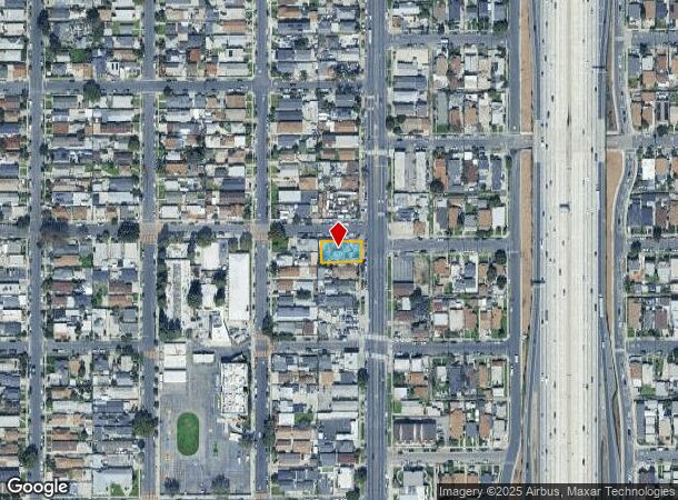
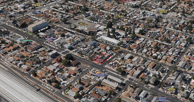
6801 S Figueroa St, Los Angeles, CA 90003
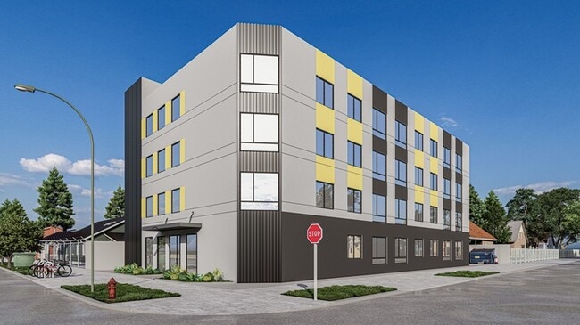
This Property Is For Sale
NEARBY LISTINGS FOR SALE OR LEASE
Property Detail
6801 S Figueroa St
Los Angeles-Long Beach-Glendale, CA
Burke Bros Figueroa St
6013-019-016
ADD NO ONE TO BURKE BROS FIGUEROA ST SUB N 20 FT (EX OF ST) OF LOT 174 AND (EX OF ST) LOT 175
Autorepair
Los Angeles
X
California
06037C1781G
174
2024
0.17 AC
2025
Inglewood/South LA
237600
Los Angeles
1,128 SF
DEMOGRAPHICS near 6801 S Figueroa St
1 Mile
3 Mile
5 Mile
2024 Total Population
62,686
465,994
1,065,004
2029 Population
59,755
446,239
1,022,924
Pop Growth 2024-2029
(4.68%)
(4.24%)
(3.95%)
Average Age
35
36
37
2024 Total Households
15,954
123,556
315,850
HH Growth 2024-2029
(5.06%)
(4.58%)
(3.96%)
Median Household Inc
$47,082
$50,001
$52,979
Avg Household Size
3.70
3.50
3.20
2024 Avg HH Vehicles
2.00
2.00
2.00
Median Home Value
$603,023
$607,691
$662,745
Median Year Built
1949
1949
1953
Nearby Places
Map Layers
Map Styles
 Street
 Aerial
- Restaurants
- Banks
- Shops
- Fitness
- Groceries
PUBLIC TRANSPORTATION
COMMUTER RAIL
Los Angeles (Coast Starlight - Amtrak, Pacific Surfliner - Amtrak, Southwest Chief - Amtrak, Texas Eagle - Amtrak)
DRIVE
WALK
Distance
Los Angeles (Coast Starlight - Amtrak, Pacific Surfliner - Amtrak, Southwest Chief - Amtrak, Texas Eagle - Amtrak)
11 min
7.5 mi
Union Station (91 Line - Southern California Regional Rail Authority (Metrolink), Antelope Valley Line - Southern California Regional Rail Authority (Metrolink), Orange County Line - Southern California Regional Rail Authority (Metrolink), Riverside Line - Southern California Regional Rail Authority (Metrolink), San Bernardino Line - Southern California Regional Rail Authority (Metrolink), Ventura County Line - Southern California Regional Rail Authority (Metrolink))
DRIVE
WALK
Distance
Union Station (91 Line - Southern California Regional Rail Authority (Metrolink), Antelope Valley Line - Southern California Regional Rail Authority (Metrolink), Orange County Line - Southern California Regional Rail Authority (Metrolink), Riverside Line - Southern California Regional Rail Authority (Metrolink), San Bernardino Line - Southern California Regional Rail Authority (Metrolink), Ventura County Line - Southern California Regional Rail Authority (Metrolink))
13 min
7.7 mi
AIRPORT
Los Angeles International
DRIVE
WALK
Distance
Los Angeles International
16 min
8.8 mi
Long Beach (Daugherty Field)
DRIVE
WALK
Distance
Long Beach (Daugherty Field)
23 min
17.2 mi
Bob Hope
DRIVE
WALK
Distance
Bob Hope
31 min
22.7 mi
Freight Ports
Port of Long Beach
DRIVE
WALK
Distance
Port of Long Beach
26 min
19.1 mi
Nearby Properties
Address
Land Use
TOTAL SIZE
Lot Size
Zoning
Address
Land Use
TOTAL SIZE
Lot Size
Zoning
2,531,696 SF
79.60 AC
INCR*
Address
Land Use
TOTAL SIZE
Lot Size
Zoning
420,864 SF
63.07 AC
LAUSC-1A
Address
Land Use
TOTAL SIZE
Lot Size
Zoning
256,059 SF
Address
Land Use
TOTAL SIZE
Lot Size
Zoning
298,630 SF
4.64 AC
LAUSC-1B
Address
Land Use
TOTAL SIZE
Lot Size
Zoning
108,598 SF
15.93 AC
LCC3*
Address
Land Use
TOTAL SIZE
Lot Size
Zoning
Address
Land Use
TOTAL SIZE
Lot Size
Zoning
95,639 SF
0.53 AC
LAC2
Address
Land Use
TOTAL SIZE
Lot Size
Zoning
116,827 SF
0.64 AC
LAC2
Address
Land Use
TOTAL SIZE
Lot Size
Zoning
57,488 SF
4.30 AC
LAPF
Address
Land Use
TOTAL SIZE
Lot Size
Zoning
564,529 SF
2.67 AC
LAUSC-1B
Address
Land Use
TOTAL SIZE
Lot Size
Zoning
261,540 SF
10.85 AC
VEM*
Address
Land Use
TOTAL SIZE
Lot Size
Zoning
150,790 SF
0.74 AC
LAC2
Address
Land Use
TOTAL SIZE
Lot Size
Zoning
261,502 SF
0.84 AC
LACM
Address
Land Use
TOTAL SIZE
Lot Size
Zoning
134,044 SF
1.90 AC
LAC2
Address
Land Use
TOTAL SIZE
Lot Size
Zoning
729,505 SF
8.74 AC
LAUSC-1A
Address
Land Use
TOTAL SIZE
Lot Size
Zoning
127,484 SF
7.33 AC
LAM2
Address
Land Use
TOTAL SIZE
Lot Size
Zoning
165,235 SF
1.13 AC
LAM2
Address
Land Use
TOTAL SIZE
Lot Size
Zoning
353,009 SF
3.97 AC
LAUSC-2
Address
Land Use
TOTAL SIZE
Lot Size
Zoning
81,735 SF
4.10 AC
LAR4
Address
Land Use
TOTAL SIZE
Lot Size
Zoning
905,884 SF
4.38 AC
LAUSC-2
Address
Land Use
TOTAL SIZE
Lot Size
Zoning
134,514 SF
1.94 AC
LCM2*
Address
Land Use
TOTAL SIZE
Lot Size
Zoning
103,656 SF
6.98 AC
LCM1
Address
Land Use
TOTAL SIZE
Lot Size
Zoning
102,719 SF
5.50 AC
LARD2
Address
Land Use
TOTAL SIZE
Lot Size
Zoning
402,118 SF
9.39 AC
LAC2
Address
Land Use
TOTAL SIZE
Lot Size
Zoning
133,455 SF
1.04 AC
LAC2
Address
Land Use
TOTAL SIZE
Lot Size
Zoning
111,213 SF
12.04 AC
LAR4
Address
Land Use
TOTAL SIZE
Lot Size
Zoning
173,222 SF
0.96 AC
LAR3
Address
Land Use
TOTAL SIZE
Lot Size
Zoning
188,030 SF
3.09 AC
LAR5
Address
Land Use
TOTAL SIZE
Lot Size
Zoning
103,896 SF
5.06 AC
VEM*
Address
Land Use
TOTAL SIZE
Lot Size
Zoning
115,366 SF
0.85 AC
LAM1
The World's #1 Commercial Real Estate Marketplace
Connect with us
© 2025 CoStar Group
The information above has been obtained from sources believed reliable. While we do not doubt its accuracy we have not verified it and make no guarantee, warranty or representation about it. It is your responsibility to independently confirm its accuracy and completeness. Any projections, opinions, assumptions, or estimates used are for example only and do not represent the current or future performance of the property. The value of this transaction to you depends on tax and other factors which should be evaluated by your tax, financial, and legal advisors. You and your advisors should conduct a careful, independent investigation of the property to determine to your satisfaction the suitability of the property for your needs.