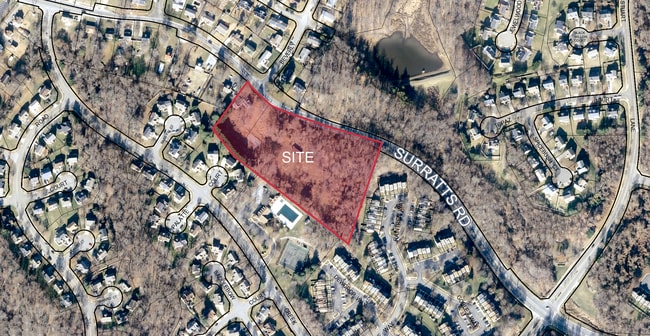
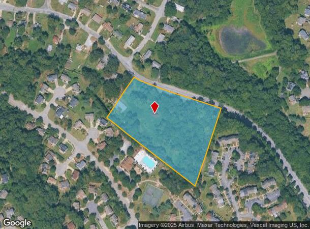
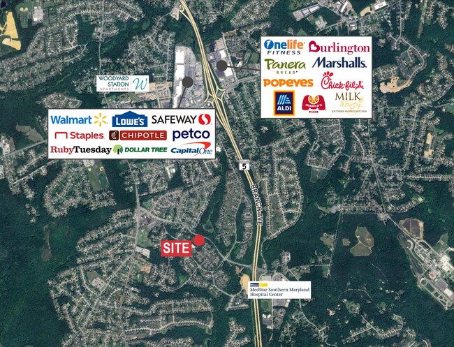
Property Record
6815 Surratts Rd, Clinton, MD 20735
This Property Is For Sale
NEARBY LISTINGS FOR SALE OR LEASE
Property Detail
6815 Surratts Rd
Washington-Arlington-Alexandria, DC-VA-MD-WV
Prince George's
09-0932269
Maryland
Residentialnec
5 AC
X
Branch Avenue Corridor
24033C0245E
Washington, DC
2,131 SF
DEMOGRAPHICS near 6815 Surratts Rd
1 Mile
3 Mile
5 Mile
2024 Total Population
8,809
40,328
100,646
2029 Population
8,610
39,618
99,021
Pop Growth 2024-2029
(2.26%)
(1.76%)
(1.61%)
Average Age
45
44
43
2024 Total Households
2,854
13,807
34,872
HH Growth 2024-2029
(2.49%)
(1.93%)
(1.75%)
Median Household Inc
$133,254
$115,852
$115,671
Avg Household Size
2.90
2.80
2.80
2024 Avg HH Vehicles
2.00
2.00
2.00
Median Home Value
$389,621
$384,860
$396,109
Median Year Built
1986
1986
1983
Nearby Places
Map Layers
Map Styles
 Street
 Aerial
- Restaurants
- Banks
- Shops
- Fitness
- Groceries
PUBLIC TRANSPORTATION
AIRPORT
Ronald Reagan Washington Ntl
DRIVE
WALK
Distance
Ronald Reagan Washington Ntl
31 min
18.0 mi
Freight Ports
Port of Baltimore
DRIVE
WALK
Distance
Port of Baltimore
67 min
46.9 mi
Nearby Properties
Address
Land Use
TOTAL SIZE
Lot Size
Zoning
Address
Land Use
TOTAL SIZE
Lot Size
Zoning
353,064 SF
53.19 AC
CGO
Address
Land Use
TOTAL SIZE
Lot Size
Zoning
7,000 SF
354.62 AC
ROS
Address
Land Use
TOTAL SIZE
Lot Size
Zoning
341,372 SF
14.74 AC
RR
Address
Land Use
TOTAL SIZE
Lot Size
Zoning
223,219 SF
22 AC
CGO
Address
Land Use
TOTAL SIZE
Lot Size
Zoning
160,870 SF
3.75 AC
RMF48
Address
Land Use
TOTAL SIZE
Lot Size
Zoning
55,724 SF
10.09 AC
IE
Address
Land Use
TOTAL SIZE
Lot Size
Zoning
939.06 AC
RR
Address
Land Use
TOTAL SIZE
Lot Size
Zoning
78,658 SF
9.13 AC
RR
Address
Land Use
TOTAL SIZE
Lot Size
Zoning
101,979 SF
2.11 AC
CGO
Address
Land Use
TOTAL SIZE
Lot Size
Zoning
161,410 SF
30 AC
RSF95
Address
Land Use
TOTAL SIZE
Lot Size
Zoning
4.56 AC
CGO
Address
Land Use
TOTAL SIZE
Lot Size
Zoning
0.72 AC
IE
Address
Land Use
TOTAL SIZE
Lot Size
Zoning
68,304 SF
8.09 AC
RSF95
Address
Land Use
TOTAL SIZE
Lot Size
Zoning
100,660 SF
9.12 AC
CGO
Address
Land Use
TOTAL SIZE
Lot Size
Zoning
122.43 AC
IE
Address
Land Use
TOTAL SIZE
Lot Size
Zoning
134,247 SF
9.24 AC
CGO
Address
Land Use
TOTAL SIZE
Lot Size
Zoning
120,686 SF
16.40 AC
RSF95
Address
Land Use
TOTAL SIZE
Lot Size
Zoning
41.87 AC
IE
Address
Land Use
TOTAL SIZE
Lot Size
Zoning
9,137 SF
136.67 AC
RSF95
Address
Land Use
TOTAL SIZE
Lot Size
Zoning
141.85 AC
IE
Address
Land Use
TOTAL SIZE
Lot Size
Zoning
118.41 AC
IE
Address
Land Use
TOTAL SIZE
Lot Size
Zoning
28.09 AC
IE
Address
Land Use
TOTAL SIZE
Lot Size
Zoning
63,499 SF
1.24 AC
CS
Address
Land Use
TOTAL SIZE
Lot Size
Zoning
62,748 SF
1.13 AC
CS
Address
Land Use
TOTAL SIZE
Lot Size
Zoning
71,100 SF
3.30 AC
CGO
Address
Land Use
TOTAL SIZE
Lot Size
Zoning
3.35 AC
RMF48
Address
Land Use
TOTAL SIZE
Lot Size
Zoning
87,622 SF
5.74 AC
RR
Address
Land Use
TOTAL SIZE
Lot Size
Zoning
96,396 SF
16.63 AC
RSF95
Address
Land Use
TOTAL SIZE
Lot Size
Zoning
84,936 SF
3.48 AC
RSF95
Address
Land Use
TOTAL SIZE
Lot Size
Zoning
35.70 AC
IE
The World's #1 Commercial Real Estate Marketplace
Connect with us
© 2025 CoStar Group
The information above has been obtained from sources believed reliable. While we do not doubt its accuracy we have not verified it and make no guarantee, warranty or representation about it. It is your responsibility to independently confirm its accuracy and completeness. Any projections, opinions, assumptions, or estimates used are for example only and do not represent the current or future performance of the property. The value of this transaction to you depends on tax and other factors which should be evaluated by your tax, financial, and legal advisors. You and your advisors should conduct a careful, independent investigation of the property to determine to your satisfaction the suitability of the property for your needs.