Property Record
6830 Lone Tree Way, Brentwood, CA 94513
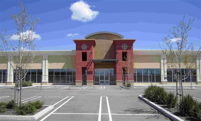

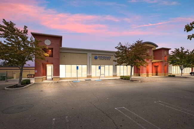

Property Detail
6830 Lone Tree Way
019-010-064-4
PCL MAP 199 PG 45 POR PCLS 1, 2 & 3
Storebuilding
Contra Costa
B and X Area of moderate flood hazard, usually the area between the limits of the 100-year and 500-year floods.
California
2025
1 AC
2025
Antioch/Pittsburg
303209
East Bay/Oakland
9,899 SF
Oakland-Fremont-Berkeley, CA
NEARBY LISTINGS FOR SALE OR LEASE
DEMOGRAPHICS near 6830 Lone Tree Way
1 mile
3 mile
5 mile
2025 Total Population
12,946
117,812
186,400
2030 Population
13,160
119,787
189,349
Pop Growth 2025-2030
+ 1.65%
+ 1.68%
+ 1.58%
Average Age
38
39
40
2025 Total Households
3,548
35,770
57,520
HH Growth 2025-2030
+ 1.69%
+ 1.71%
+ 1.63%
Median Household Inc
$157,350
$132,982
$126,275
Avg Household Size
3.50
3.20
3.20
2025 Avg HH Vehicles
3.00
2.00
2.00
Median Home Value
$827,498
$746,559
$743,712
Median Year Built
2005
1998
1997
Nearby Places
Map Layers
Map Styles
 Street
 Aerial
Layers
 Traffic
 Biking
Places
Listings with unknown addresses are not visible on the map
- Restaurants
- Banks
- Shops
- Fitness
- Groceries
PUBLIC TRANSPORTATION
AIRPORT
Stockton Metro
Drive
Walk
Distance
Stockton Metro
56 min
34.5 mi
SALE & LEASE HISTORY
LISTING DATE
SALE/LEASE

Dec 01, 2025
For Sale
Nearby Properties
Address
Land Use
TOTAL SIZE
Lot Size
Zoning
Address
Land Use
TOTAL SIZE
Lot Size
Zoning
340,300 SF
35.04 AC
Address
Land Use
TOTAL SIZE
Lot Size
Zoning
57.12 AC
Address
Land Use
TOTAL SIZE
Lot Size
Zoning
9,999 SF
32.23 AC
Address
Land Use
TOTAL SIZE
Lot Size
Zoning
39,038 SF
14.43 AC
Address
Land Use
TOTAL SIZE
Lot Size
Zoning
55.08 AC
Address
Land Use
TOTAL SIZE
Lot Size
Zoning
14,968 SF
7.07 AC
Address
Land Use
TOTAL SIZE
Lot Size
Zoning
129,450 SF
6.69 AC
Address
Land Use
TOTAL SIZE
Lot Size
Zoning
67,691 SF
28.26 AC
Address
Land Use
TOTAL SIZE
Lot Size
Zoning
67,133 SF
8.65 AC
Address
Land Use
TOTAL SIZE
Lot Size
Zoning
35,995 SF
91.24 AC
Address
Land Use
TOTAL SIZE
Lot Size
Zoning
117,486 SF
7.26 AC
Address
Land Use
TOTAL SIZE
Lot Size
Zoning
220,840 SF
13.67 AC
Address
Land Use
TOTAL SIZE
Lot Size
Zoning
15,000 SF
17.17 AC
Address
Land Use
TOTAL SIZE
Lot Size
Zoning
59,066 SF
3.89 AC
Address
Land Use
TOTAL SIZE
Lot Size
Zoning
37,834 SF
9.52 AC
Address
Land Use
TOTAL SIZE
Lot Size
Zoning
115,013 SF
6.54 AC
Address
Land Use
TOTAL SIZE
Lot Size
Zoning
97,310 SF
5.85 AC
Address
Land Use
TOTAL SIZE
Lot Size
Zoning
113,902 SF
9.71 AC
Address
Land Use
TOTAL SIZE
Lot Size
Zoning
157,933 SF
19.04 AC
Address
Land Use
TOTAL SIZE
Lot Size
Zoning
168,442 SF
17.46 AC
Address
Land Use
TOTAL SIZE
Lot Size
Zoning
184,623 SF
6.59 AC
Address
Land Use
TOTAL SIZE
Lot Size
Zoning
141,367 SF
4.72 AC
Address
Land Use
TOTAL SIZE
Lot Size
Zoning
107,230 SF
1.54 AC
Address
Land Use
TOTAL SIZE
Lot Size
Zoning
12,410 SF
5.38 AC
Address
Land Use
TOTAL SIZE
Lot Size
Zoning
40,054 SF
3.39 AC
Address
Land Use
TOTAL SIZE
Lot Size
Zoning
24,156 SF
14.47 AC
Address
Land Use
TOTAL SIZE
Lot Size
Zoning
13,468 SF
8.77 AC
Address
Land Use
TOTAL SIZE
Lot Size
Zoning
126,509 SF
11.47 AC
Address
Land Use
TOTAL SIZE
Lot Size
Zoning
65,898 SF
8.72 AC
Address
Land Use
TOTAL SIZE
Lot Size
Zoning
147,868 SF
7.83 AC
The World's #1 Commercial Real Estate Marketplace
Connect with us
© 2026 CoStar Group
The information above has been obtained from sources believed reliable. While we do not doubt its accuracy we have not verified it and make no guarantee, warranty or representation about it. It is your responsibility to independently confirm its accuracy and completeness. Any projections, opinions, assumptions, or estimates used are for example only and do not represent the current or future performance of the property. The value of this transaction to you depends on tax and other factors which should be evaluated by your tax, financial, and legal advisors. You and your advisors should conduct a careful, independent investigation of the property to determine to your satisfaction the suitability of the property for your needs.