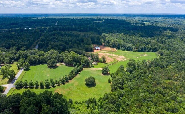
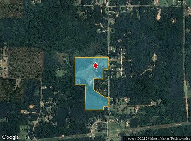
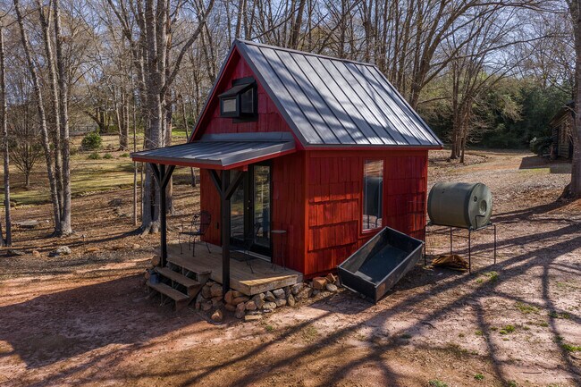
Property Record
685 N Mcdonough Rd, Griffin, GA 30223
NEARBY LISTINGS FOR SALE OR LEASE
Property Detail
685 N Mcdonough Rd
Atlanta-Sandy Springs-Roswell, GA
Lynette Ivan
213-05-005-B
Spalding
Sfr
Georgia
X
48.86 AC
13255C0090E
Spalding County
7,506 SF
Atlanta
DEMOGRAPHICS near 685 N Mcdonough Rd
1 Mile
3 Mile
5 Mile
2024 Total Population
690
5,865
31,616
2029 Population
726
6,198
33,575
Pop Growth 2024-2029
+ 5.22%
+ 5.68%
+ 6.20%
Average Age
41
41
41
2024 Total Households
263
2,236
12,318
HH Growth 2024-2029
+ 4.94%
+ 5.59%
+ 6.14%
Median Household Inc
$46,389
$60,494
$51,534
Avg Household Size
2.60
2.60
2.50
2024 Avg HH Vehicles
2.00
2.00
2.00
Median Home Value
$167,525
$189,068
$204,589
Median Year Built
1990
1987
1980
Nearby Places
Map Layers
Map Styles
 Street
 Aerial
- Restaurants
- Banks
- Shops
- Fitness
- Groceries
PUBLIC TRANSPORTATION
AIRPORT
Hartsfield - Jackson Atlanta International
DRIVE
WALK
Distance
Hartsfield - Jackson Atlanta International
47 min
35.6 mi
Freight Ports
Georgia Ports - Savannah
DRIVE
WALK
Distance
Georgia Ports - Savannah
240 min
214.1 mi
SALE & LEASE HISTORY
LISTING DATE
SALE/LEASE

Feb 21, 2023
For Sale
Nearby Properties
Address
Land Use
TOTAL SIZE
Lot Size
Zoning
Address
Land Use
TOTAL SIZE
Lot Size
Zoning
303,594 SF
58.69 AC
PDD
Address
Land Use
TOTAL SIZE
Lot Size
Zoning
367,793 SF
223.84 AC
C2
Address
Land Use
TOTAL SIZE
Lot Size
Zoning
13,392 SF
31.70 AC
Address
Land Use
TOTAL SIZE
Lot Size
Zoning
39,105 SF
33.98 AC
PDD
Address
Land Use
TOTAL SIZE
Lot Size
Zoning
48,856 SF
35.46 AC
PDD
Address
Land Use
TOTAL SIZE
Lot Size
Zoning
99,469 SF
28.98 AC
R-2
Address
Land Use
TOTAL SIZE
Lot Size
Zoning
72,876 SF
16.23 AC
PDD
Address
Land Use
TOTAL SIZE
Lot Size
Zoning
39,105 SF
33.98 AC
PDD
Address
Land Use
TOTAL SIZE
Lot Size
Zoning
48,856 SF
33.47 AC
PDD
Address
Land Use
TOTAL SIZE
Lot Size
Zoning
62,748 SF
22 AC
PDD
Address
Land Use
TOTAL SIZE
Lot Size
Zoning
16,698 SF
34.19 AC
AR1
Address
Land Use
TOTAL SIZE
Lot Size
Zoning
303,594 SF
58.69 AC
PDD
Address
Land Use
TOTAL SIZE
Lot Size
Zoning
46,310 SF
24.68 AC
R3
Address
Land Use
TOTAL SIZE
Lot Size
Zoning
55,202 SF
15.95 AC
C2
Address
Land Use
TOTAL SIZE
Lot Size
Zoning
72,816 SF
16.23 AC
PDD
Address
Land Use
TOTAL SIZE
Lot Size
Zoning
6,640 SF
2.93 AC
C1
Address
Land Use
TOTAL SIZE
Lot Size
Zoning
70 SF
281.50 AC
PDD
Address
Land Use
TOTAL SIZE
Lot Size
Zoning
7,686 SF
2 AC
C-1
Address
Land Use
TOTAL SIZE
Lot Size
Zoning
Address
Land Use
TOTAL SIZE
Lot Size
Zoning
9,360 SF
2 AC
C-1
Address
Land Use
TOTAL SIZE
Lot Size
Zoning
11,106 SF
4.04 AC
C-2
Address
Land Use
TOTAL SIZE
Lot Size
Zoning
290.41 AC
AR1/R2
Address
Land Use
TOTAL SIZE
Lot Size
Zoning
167.93 AC
R2
Address
Land Use
TOTAL SIZE
Lot Size
Zoning
203.23 AC
Address
Land Use
TOTAL SIZE
Lot Size
Zoning
62,748 SF
22 AC
PDD
Address
Land Use
TOTAL SIZE
Lot Size
Zoning
600 SF
25.53 AC
R2/AR1
Address
Land Use
TOTAL SIZE
Lot Size
Zoning
206.93 AC
Address
Land Use
TOTAL SIZE
Lot Size
Zoning
131.92 AC
R1
Address
Land Use
TOTAL SIZE
Lot Size
Zoning
250,024 SF
9.66 AC
C2
Address
Land Use
TOTAL SIZE
Lot Size
Zoning
3,920 SF
135.75 AC
The World's #1 Commercial Real Estate Marketplace
Connect with us
© 2025 CoStar Group
The information above has been obtained from sources believed reliable. While we do not doubt its accuracy we have not verified it and make no guarantee, warranty or representation about it. It is your responsibility to independently confirm its accuracy and completeness. Any projections, opinions, assumptions, or estimates used are for example only and do not represent the current or future performance of the property. The value of this transaction to you depends on tax and other factors which should be evaluated by your tax, financial, and legal advisors. You and your advisors should conduct a careful, independent investigation of the property to determine to your satisfaction the suitability of the property for your needs.