Property Record
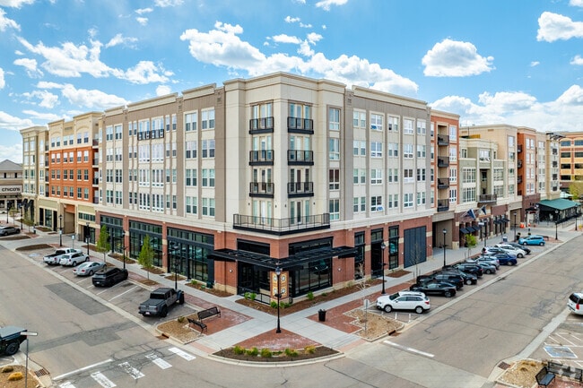
6851 S Gaylord St, Centennial, CO 80122
NEARBY LISTINGS FOR SALE OR LEASE
Property Detail
6851 S Gaylord St
Denver-Aurora-Lakewood, CO
Streets At Southglenn 1St Flg
2077-26-1-30-016
SUBDIVISIONCD 060145 SUBDIVISIONNAME STREETS AT SOUTHGLENN 1ST FLG BLOCK 001 LOT 006 THAT PART OF LOT 6 BLK 1 STREETS AT SOUTHGLENN SUB 1ST FLG NOW KNOWN AS UNIT 2A PER MASTER COMMUNITY SURVEY MAP RECORDED AT RECEPTION #D0028222
Apartment
Arapahoe
X
Colorado
08005C0454L
006
2024
2.19 AC
2025
West Centennial
005626
Denver
308,385 SF
DEMOGRAPHICS near 6851 S Gaylord St
1 Mile
3 Mile
5 Mile
2024 Total Population
12,134
101,418
290,465
2029 Population
12,086
103,196
303,118
Pop Growth 2024-2029
(0.40%)
+ 1.75%
+ 4.36%
Average Age
43
43
41
2024 Total Households
4,914
40,640
120,461
HH Growth 2024-2029
(0.45%)
+ 1.88%
+ 4.17%
Median Household Inc
$101,945
$110,027
$108,629
Avg Household Size
2.40
2.40
2.40
2024 Avg HH Vehicles
2.00
2.00
2.00
Median Home Value
$611,123
$661,020
$647,161
Median Year Built
1970
1978
1986
Nearby Places
Map Layers
Map Styles
 Street
 Aerial
- Restaurants
- Banks
- Shops
- Fitness
- Groceries
PUBLIC TRANSPORTATION
AIRPORT
Denver International
DRIVE
WALK
Distance
Denver International
42 min
32.9 mi
Freight Ports
Tulsa Port Of Catoosa
DRIVE
WALK
Distance
Tulsa Port Of Catoosa
738 min
720.4 mi
SALE & LEASE HISTORY
LISTING DATE
SALE/LEASE

Sep 25, 2016
For Lease
May 23, 2023
For Lease
May 23, 2023
For Lease
Nearby Properties
Address
Land Use
TOTAL SIZE
Lot Size
Zoning
Address
Land Use
TOTAL SIZE
Lot Size
Zoning
443,472 SF
7.88 AC
AMU
Address
Land Use
TOTAL SIZE
Lot Size
Zoning
481,147 SF
38.27 AC
Address
Land Use
TOTAL SIZE
Lot Size
Zoning
207,637 SF
28.17 AC
PDU
Address
Land Use
TOTAL SIZE
Lot Size
Zoning
98,523 SF
4.17 AC
Address
Land Use
TOTAL SIZE
Lot Size
Zoning
206,632 SF
33.68 AC
Address
Land Use
TOTAL SIZE
Lot Size
Zoning
250,402 SF
21 AC
Address
Land Use
TOTAL SIZE
Lot Size
Zoning
38,992 SF
1 AC
Address
Land Use
TOTAL SIZE
Lot Size
Zoning
42,444 SF
1.41 AC
Address
Land Use
TOTAL SIZE
Lot Size
Zoning
58,006 SF
1.80 AC
Address
Land Use
TOTAL SIZE
Lot Size
Zoning
329,937 SF
35.07 AC
PUD
Address
Land Use
TOTAL SIZE
Lot Size
Zoning
192,108 SF
20.03 AC
Address
Land Use
TOTAL SIZE
Lot Size
Zoning
167,287 SF
13.65 AC
Address
Land Use
TOTAL SIZE
Lot Size
Zoning
177,772 SF
16 AC
Address
Land Use
TOTAL SIZE
Lot Size
Zoning
150,767 SF
14.49 AC
PDU
Address
Land Use
TOTAL SIZE
Lot Size
Zoning
411,924 SF
26.85 AC
LPDI
Address
Land Use
TOTAL SIZE
Lot Size
Zoning
163,695 SF
22.90 AC
Address
Land Use
TOTAL SIZE
Lot Size
Zoning
572,657 SF
0.21 AC
LPD-C
Address
Land Use
TOTAL SIZE
Lot Size
Zoning
152,384 SF
12.89 AC
PDU
Address
Land Use
TOTAL SIZE
Lot Size
Zoning
312,130 SF
20.63 AC
PDU
Address
Land Use
TOTAL SIZE
Lot Size
Zoning
90,350 SF
11.44 AC
Address
Land Use
TOTAL SIZE
Lot Size
Zoning
463,840 SF
17.63 AC
PDU
Address
Land Use
TOTAL SIZE
Lot Size
Zoning
61,607 SF
11.60 AC
LPD-C
Address
Land Use
TOTAL SIZE
Lot Size
Zoning
87,291 SF
9.25 AC
Address
Land Use
TOTAL SIZE
Lot Size
Zoning
248,058 SF
12.24 AC
Address
Land Use
TOTAL SIZE
Lot Size
Zoning
146,156 SF
4.61 AC
Address
Land Use
TOTAL SIZE
Lot Size
Zoning
677,688 SF
2.97 AC
Address
Land Use
TOTAL SIZE
Lot Size
Zoning
28,562 SF
9.47 AC
Address
Land Use
TOTAL SIZE
Lot Size
Zoning
131,886 SF
8.39 AC
Address
Land Use
TOTAL SIZE
Lot Size
Zoning
127,932 SF
3.82 AC
Address
Land Use
TOTAL SIZE
Lot Size
Zoning
66,777 SF
5.04 AC
The World's #1 Commercial Real Estate Marketplace
Connect with us
© 2026 CoStar Group
The information above has been obtained from sources believed reliable. While we do not doubt its accuracy we have not verified it and make no guarantee, warranty or representation about it. It is your responsibility to independently confirm its accuracy and completeness. Any projections, opinions, assumptions, or estimates used are for example only and do not represent the current or future performance of the property. The value of this transaction to you depends on tax and other factors which should be evaluated by your tax, financial, and legal advisors. You and your advisors should conduct a careful, independent investigation of the property to determine to your satisfaction the suitability of the property for your needs.