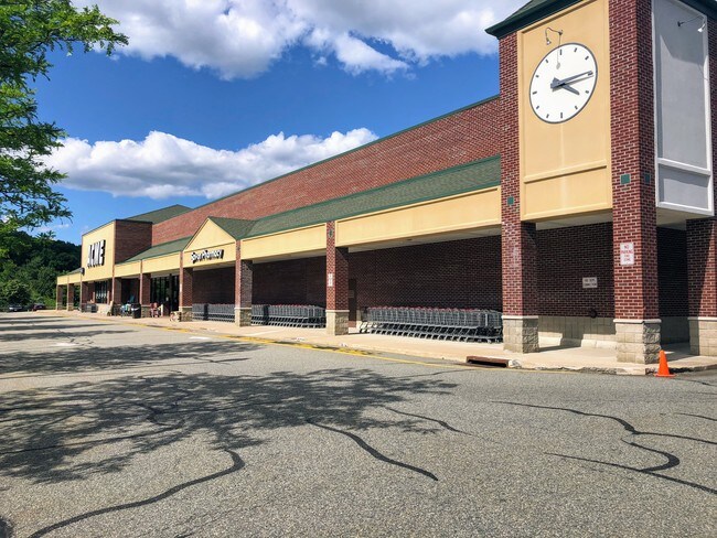
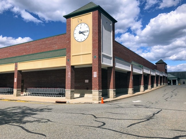
Property Record
690 Millbrook Ave, Randolph, NJ 07869

Property Detail
690 Millbrook Ave
Newark, NJ
ADDITIONAL LOTS: B92 L11
32-00119-0000-00105
Morris
Commercialnec
New Jersey
VCC
105
2024
6.21 AC
2025
Western Morris
045704
Northern New Jersey
NEARBY LISTINGS FOR SALE OR LEASE
DEMOGRAPHICS near 690 Millbrook Ave
1 mile
3 mile
5 mile
2025 Total Population
3,439
30,643
111,914
2030 Population
3,500
31,284
114,417
Pop Growth 2025-2030
+ 1.77%
+ 2.09%
+ 2.24%
Average Age
41
41
41
2025 Total Households
1,187
10,878
38,609
HH Growth 2025-2030
+ 1.77%
+ 2.33%
+ 2.35%
Median Household Inc
$211,129
$183,398
$139,061
Avg Household Size
2.90
2.70
2.80
2025 Avg HH Vehicles
2.00
2.00
2.00
Median Home Value
$742,350
$740,787
$624,896
Median Year Built
1984
1978
1970
Nearby Places
Map Layers
Map Styles
 Street
 Aerial
Layers
 Traffic
 Biking
Places
Listings with unknown addresses are not visible on the map
- Restaurants
- Banks
- Shops
- Fitness
- Groceries
PUBLIC TRANSPORTATION
COMMUTER RAIL
Dover (Montclair-Boonton Line - NJ Transit Commuter Rail (NJ Transit), Morris & Essex Morristown Line - NJ Transit Commuter Rail (NJ Transit))
Drive
Walk
Distance
Dover (Montclair-Boonton Line - NJ Transit Commuter Rail (NJ Transit), Morris & Essex Morristown Line - NJ Transit Commuter Rail (NJ Transit))
9 min
5.0 mi
Morris Plains (Morris & Essex Morristown Line - NJ Transit Commuter Rail (NJ Transit))
Drive
Walk
Distance
Morris Plains (Morris & Essex Morristown Line - NJ Transit Commuter Rail (NJ Transit))
13 min
6.9 mi
AIRPORT
Newark Liberty International
Drive
Walk
Distance
Newark Liberty International
38 min
27.4 mi
Freight Ports
Maher Terminal
Drive
Walk
Distance
Maher Terminal
41 min
27.9 mi
Nearby Properties
Address
Land Use
TOTAL SIZE
Lot Size
Zoning
Address
Land Use
TOTAL SIZE
Lot Size
Zoning
222.79 AC
R1
Address
Land Use
TOTAL SIZE
Lot Size
Zoning
64.62 AC
R3
Address
Land Use
TOTAL SIZE
Lot Size
Zoning
28.62 AC
OSGU
Address
Land Use
TOTAL SIZE
Lot Size
Zoning
197,412 SF
28.60 AC
OSGU
Address
Land Use
TOTAL SIZE
Lot Size
Zoning
11,441 SF
109.20 AC
OSGU
Address
Land Use
TOTAL SIZE
Lot Size
Zoning
Address
Land Use
TOTAL SIZE
Lot Size
Zoning
19.47 AC
R-4
Address
Land Use
TOTAL SIZE
Lot Size
Zoning
16.21 AC
R-4
Address
Land Use
TOTAL SIZE
Lot Size
Zoning
22,289 SF
5 AC
R1
Address
Land Use
TOTAL SIZE
Lot Size
Zoning
9.81 AC
B2
Address
Land Use
TOTAL SIZE
Lot Size
Zoning
14.47 AC
OBDS
Address
Land Use
TOTAL SIZE
Lot Size
Zoning
12.61 AC
R-4
Address
Land Use
TOTAL SIZE
Lot Size
Zoning
68,830 SF
22 AC
OSGU
Address
Land Use
TOTAL SIZE
Lot Size
Zoning
7.79 AC
B-4
Address
Land Use
TOTAL SIZE
Lot Size
Zoning
2,396 SF
28.60 AC
R
Address
Land Use
TOTAL SIZE
Lot Size
Zoning
3.50 AC
B-2
Address
Land Use
TOTAL SIZE
Lot Size
Zoning
81,701 SF
107.15 AC
R-R
Address
Land Use
TOTAL SIZE
Lot Size
Zoning
20.16 AC
I-1
Address
Land Use
TOTAL SIZE
Lot Size
Zoning
64,687 SF
15.79 AC
R3
Address
Land Use
TOTAL SIZE
Lot Size
Zoning
38,526 SF
10 AC
R2
Address
Land Use
TOTAL SIZE
Lot Size
Zoning
Address
Land Use
TOTAL SIZE
Lot Size
Zoning
70,228 SF
16.24 AC
R3
Address
Land Use
TOTAL SIZE
Lot Size
Zoning
68,586 SF
15 AC
R1
Address
Land Use
TOTAL SIZE
Lot Size
Zoning
5,995 SF
5.90 AC
B-2
Address
Land Use
TOTAL SIZE
Lot Size
Zoning
216.96 AC
R-10
Address
Land Use
TOTAL SIZE
Lot Size
Zoning
14.57 AC
R-10
Address
Land Use
TOTAL SIZE
Lot Size
Zoning
8.04 AC
RGAH
Address
Land Use
TOTAL SIZE
Lot Size
Zoning
21.95 AC
R-10
Address
Land Use
TOTAL SIZE
Lot Size
Zoning
109,100 SF
20.04 AC
R2
The World's #1 Commercial Real Estate Marketplace
Connect with us
© 2026 CoStar Group
The information above has been obtained from sources believed reliable. While we do not doubt its accuracy we have not verified it and make no guarantee, warranty or representation about it. It is your responsibility to independently confirm its accuracy and completeness. Any projections, opinions, assumptions, or estimates used are for example only and do not represent the current or future performance of the property. The value of this transaction to you depends on tax and other factors which should be evaluated by your tax, financial, and legal advisors. You and your advisors should conduct a careful, independent investigation of the property to determine to your satisfaction the suitability of the property for your needs.