Property Record
690 N State St, Hemet, CA 92543


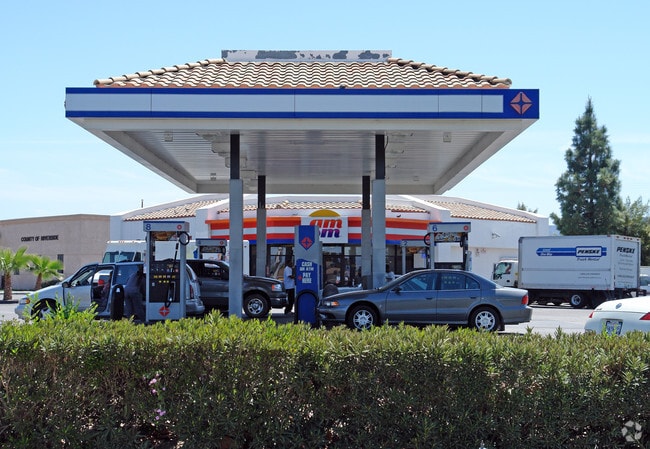

Property Detail
690 N State St
443-060-023
.91 ACRES M/L IN POR PARS 1 & 2 PM 054/098 PM 8296
Servicestation
RIVERSIDE
C2
California
B and X Area of moderate flood hazard, usually the area between the limits of the 100-year and 500-year floods.
1,2
2024
0.91 AC
2025
Beaumont/Hemet
043521
Inland Empire (California)
2,705 SF
Riverside-San Bernardino-Ontario, CA
NEARBY LISTINGS FOR SALE OR LEASE
DEMOGRAPHICS near 690 N State St
1 mile
3 mile
5 mile
2025 Total Population
17,747
135,060
186,514
2030 Population
18,422
139,086
192,244
Pop Growth 2025-2030
+ 3.80%
+ 2.98%
+ 3.07%
Average Age
37
38
38
2025 Total Households
6,171
43,820
60,439
HH Growth 2025-2030
+ 3.50%
+ 2.63%
+ 2.71%
Median Household Inc
$45,577
$58,906
$64,197
Avg Household Size
2.80
2.90
2.90
2025 Avg HH Vehicles
2.00
2.00
2.00
Median Home Value
$272,780
$358,380
$381,527
Median Year Built
1981
1981
1985
Nearby Places
Map Layers
Map Styles
 Street
 Aerial
Layers
 Traffic
 Biking
Places
Listings with unknown addresses are not visible on the map
- Restaurants
- Banks
- Shops
- Fitness
- Groceries
PUBLIC TRANSPORTATION
AIRPORT
Palm Springs International
Drive
Walk
Distance
Palm Springs International
56 min
45.3 mi
Freight Ports
Port of Long Beach
Drive
Walk
Distance
Port of Long Beach
117 min
88.0 mi
SALE & LEASE HISTORY
LISTING DATE
SALE/LEASE

Feb 12, 2024
For Sale
Nearby Properties
Address
Land Use
TOTAL SIZE
Lot Size
Zoning
Address
Land Use
TOTAL SIZE
Lot Size
Zoning
168,761 SF
20.67 AC
Address
Land Use
TOTAL SIZE
Lot Size
Zoning
306,540 SF
7.69 AC
Address
Land Use
TOTAL SIZE
Lot Size
Zoning
5.96 AC
Address
Land Use
TOTAL SIZE
Lot Size
Zoning
94,476 SF
4.86 AC
R3
Address
Land Use
TOTAL SIZE
Lot Size
Zoning
63,960 SF
8.57 AC
R3
Address
Land Use
TOTAL SIZE
Lot Size
Zoning
193,123 SF
19.92 AC
Address
Land Use
TOTAL SIZE
Lot Size
Zoning
165,401 SF
13.45 AC
C1
Address
Land Use
TOTAL SIZE
Lot Size
Zoning
9,184 SF
4.75 AC
R3
Address
Land Use
TOTAL SIZE
Lot Size
Zoning
50,160 SF
5.93 AC
R3
Address
Land Use
TOTAL SIZE
Lot Size
Zoning
27,964 SF
5.47 AC
Address
Land Use
TOTAL SIZE
Lot Size
Zoning
53,140 SF
6.74 AC
C2
Address
Land Use
TOTAL SIZE
Lot Size
Zoning
89,317 SF
5.77 AC
Address
Land Use
TOTAL SIZE
Lot Size
Zoning
40,880 SF
6 AC
R3
Address
Land Use
TOTAL SIZE
Lot Size
Zoning
66,482 SF
9.11 AC
A1
Address
Land Use
TOTAL SIZE
Lot Size
Zoning
167,396 SF
9.36 AC
Address
Land Use
TOTAL SIZE
Lot Size
Zoning
122,037 SF
5.52 AC
Address
Land Use
TOTAL SIZE
Lot Size
Zoning
28,145 SF
4.67 AC
R3
Address
Land Use
TOTAL SIZE
Lot Size
Zoning
70,045 SF
4.23 AC
Address
Land Use
TOTAL SIZE
Lot Size
Zoning
59,680 SF
5.80 AC
C2
Address
Land Use
TOTAL SIZE
Lot Size
Zoning
42,064 SF
4.71 AC
C1
Address
Land Use
TOTAL SIZE
Lot Size
Zoning
69,306 SF
6.02 AC
Address
Land Use
TOTAL SIZE
Lot Size
Zoning
72,308 SF
4.66 AC
M1
Address
Land Use
TOTAL SIZE
Lot Size
Zoning
58,941 SF
9.06 AC
M1
Address
Land Use
TOTAL SIZE
Lot Size
Zoning
79,683 SF
7.97 AC
C1
Address
Land Use
TOTAL SIZE
Lot Size
Zoning
58,941 SF
7.14 AC
Address
Land Use
TOTAL SIZE
Lot Size
Zoning
24,656 SF
4.32 AC
R3
Address
Land Use
TOTAL SIZE
Lot Size
Zoning
88,530 SF
18.41 AC
Address
Land Use
TOTAL SIZE
Lot Size
Zoning
202,852 SF
11.37 AC
Address
Land Use
TOTAL SIZE
Lot Size
Zoning
104,713 SF
7.49 AC
The World's #1 Commercial Real Estate Marketplace
Connect with us
© 2026 CoStar Group
The information above has been obtained from sources believed reliable. While we do not doubt its accuracy we have not verified it and make no guarantee, warranty or representation about it. It is your responsibility to independently confirm its accuracy and completeness. Any projections, opinions, assumptions, or estimates used are for example only and do not represent the current or future performance of the property. The value of this transaction to you depends on tax and other factors which should be evaluated by your tax, financial, and legal advisors. You and your advisors should conduct a careful, independent investigation of the property to determine to your satisfaction the suitability of the property for your needs.