Property Record
6900 Rail Line Ct, Gainesville, VA 20155

Property Detail
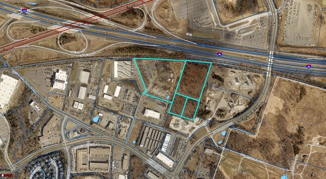
6900 Rail Line Ct
Washington-Arlington-Alexandria, DC-VA-MD-WV
PINEY BRANCH LOT 10B-1
7497-24-0955
PRINCE WILLIAM
Vacantlandnec
Virginia
M1
10b-1
B and X Area of moderate flood hazard, usually the area between the limits of the 100-year and 500-year floods.
7.33 AC
2024
Route 29/I-66 Corridor
2025
Washington, DC
901507
NEARBY LISTINGS FOR SALE OR LEASE
DEMOGRAPHICS near 6900 Rail Line Ct
1 mile
3 mile
5 mile
2025 Total Population
2,561
51,438
124,822
2030 Population
2,654
52,773
128,399
Pop Growth 2025-2030
+ 3.63%
+ 2.60%
+ 2.87%
Average Age
52
39
38
2025 Total Households
1,097
16,200
40,220
HH Growth 2025-2030
+ 4.28%
+ 2.56%
+ 2.82%
Median Household Inc
$128,743
$166,857
$149,320
Avg Household Size
2.20
3.10
3.00
2025 Avg HH Vehicles
2.00
2.00
2.00
Median Home Value
$700,996
$686,754
$661,854
Median Year Built
2006
2003
2002
Nearby Places
Map Layers
Map Styles
 Street
 Aerial
Layers
 Traffic
 Biking
Places
Listings with unknown addresses are not visible on the map
- Restaurants
- Banks
- Shops
- Fitness
- Groceries
PUBLIC TRANSPORTATION
COMMUTER RAIL
Lead (Manassas Line - Virginia Railway Express)
Drive
Walk
Distance
Lead (Manassas Line - Virginia Railway Express)
18 min
8.2 mi
Manassas Amtrak Station (Cardinal - Amtrak, Crescent - Amtrak, Manassas Line - Amtrak, Northeast Regional - Amtrak)
Drive
Walk
Distance
Manassas Amtrak Station (Cardinal - Amtrak, Crescent - Amtrak, Manassas Line - Amtrak, Northeast Regional - Amtrak)
19 min
8.4 mi
AIRPORT
Washington Dulles International
Drive
Walk
Distance
Washington Dulles International
36 min
21.9 mi
Freight Ports
Port of Baltimore
Drive
Walk
Distance
Port of Baltimore
95 min
72.3 mi
Nearby Properties
Address
Land Use
TOTAL SIZE
Lot Size
Zoning
Address
Land Use
TOTAL SIZE
Lot Size
Zoning
866,820 SF
253.92 AC
M2
Address
Land Use
TOTAL SIZE
Lot Size
Zoning
482,223 SF
28.10 AC
PBD
Address
Land Use
TOTAL SIZE
Lot Size
Zoning
389,649 SF
11.82 AC
M2
Address
Land Use
TOTAL SIZE
Lot Size
Zoning
325,918 SF
41.38 AC
M2
Address
Land Use
TOTAL SIZE
Lot Size
Zoning
560,942 SF
90.90 AC
B1
Address
Land Use
TOTAL SIZE
Lot Size
Zoning
181.29 AC
M1
Address
Land Use
TOTAL SIZE
Lot Size
Zoning
117.22 AC
M1
Address
Land Use
TOTAL SIZE
Lot Size
Zoning
252,966 SF
10.54 AC
PMD
Address
Land Use
TOTAL SIZE
Lot Size
Zoning
719,742 SF
62.13 AC
M2
Address
Land Use
TOTAL SIZE
Lot Size
Zoning
115,600 SF
10.06 AC
M1
Address
Land Use
TOTAL SIZE
Lot Size
Zoning
123,534 SF
7.85 AC
M1
Address
Land Use
TOTAL SIZE
Lot Size
Zoning
112.48 AC
M2
Address
Land Use
TOTAL SIZE
Lot Size
Zoning
312,931 SF
83 AC
M2
Address
Land Use
TOTAL SIZE
Lot Size
Zoning
127,700 SF
7.92 AC
M1
Address
Land Use
TOTAL SIZE
Lot Size
Zoning
258,716 SF
58.54 AC
M1
Address
Land Use
TOTAL SIZE
Lot Size
Zoning
165,230 SF
12 AC
M2
Address
Land Use
TOTAL SIZE
Lot Size
Zoning
350,906 SF
83.51 AC
M1
Address
Land Use
TOTAL SIZE
Lot Size
Zoning
67.20 AC
M2
Address
Land Use
TOTAL SIZE
Lot Size
Zoning
227,465 SF
31.91 AC
M1
Address
Land Use
TOTAL SIZE
Lot Size
Zoning
311,198 SF
23.50 AC
M2
Address
Land Use
TOTAL SIZE
Lot Size
Zoning
58.30 AC
M1
Address
Land Use
TOTAL SIZE
Lot Size
Zoning
52.69 AC
M2
Address
Land Use
TOTAL SIZE
Lot Size
Zoning
482,200 SF
29.18 AC
PBD
Address
Land Use
TOTAL SIZE
Lot Size
Zoning
402,166 SF
16.72 AC
M2
Address
Land Use
TOTAL SIZE
Lot Size
Zoning
380,264 SF
15.25 AC
PMD
Address
Land Use
TOTAL SIZE
Lot Size
Zoning
161.28 AC
PBD
Address
Land Use
TOTAL SIZE
Lot Size
Zoning
119.30 AC
M2
Address
Land Use
TOTAL SIZE
Lot Size
Zoning
298,474 SF
11.60 AC
PMR
Address
Land Use
TOTAL SIZE
Lot Size
Zoning
217,934 SF
10.17 AC
M2
Address
Land Use
TOTAL SIZE
Lot Size
Zoning
28.38 AC
PBD
The World's #1 Commercial Real Estate Marketplace
Connect with us
© 2026 CoStar Group
The information above has been obtained from sources believed reliable. While we do not doubt its accuracy we have not verified it and make no guarantee, warranty or representation about it. It is your responsibility to independently confirm its accuracy and completeness. Any projections, opinions, assumptions, or estimates used are for example only and do not represent the current or future performance of the property. The value of this transaction to you depends on tax and other factors which should be evaluated by your tax, financial, and legal advisors. You and your advisors should conduct a careful, independent investigation of the property to determine to your satisfaction the suitability of the property for your needs.