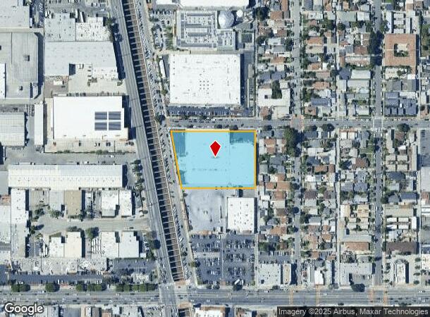
Property Record
6900 S Alameda St, Huntington Park, CA 90255
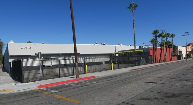


This Property Is For Sale
NEARBY LISTINGS FOR SALE OR LEASE
Property Detail
6900 S Alameda St
Los Angeles-Long Beach-Glendale, CA
4286
6321-029-016
TRACT NO 4286 LOT COM AT NE COR OF LOT A TH S ON E LINE OF SD LOT 257.78 FT TH S 89 30 W TO E LINE OF ALAMEDA ST TH N THEREON AND E ON S LINE OF SATURN ST TO BEG PART OF LOT A
Lightindustrial
Los Angeles
X
California
06037C1805F
a,257
2024
2.17 AC
2025
Vernon
533103
Los Angeles
97,345 SF
DEMOGRAPHICS near 6900 S Alameda St
1 Mile
3 Mile
5 Mile
2024 Total Population
51,578
400,877
1,019,689
2029 Population
49,157
380,831
974,148
Pop Growth 2024-2029
(4.69%)
(5.00%)
(4.47%)
Average Age
36
35
35
2024 Total Households
13,231
98,583
275,738
HH Growth 2024-2029
(5.04%)
(5.36%)
(4.56%)
Median Household Inc
$51,394
$51,396
$51,347
Avg Household Size
3.80
3.90
3.50
2024 Avg HH Vehicles
2.00
2.00
2.00
Median Home Value
$539,680
$531,730
$563,169
Median Year Built
1952
1952
1953
Nearby Places
Map Layers
Map Styles
 Street
 Aerial
- Restaurants
- Banks
- Shops
- Fitness
- Groceries
PUBLIC TRANSPORTATION
TRANSIT/SUBWAY
Florence Station (Blue Line - Los Angeles County Metropolitan Transportation Authority (Metro))
DRIVE
WALK
Distance
Florence Station (Blue Line - Los Angeles County Metropolitan Transportation Authority (Metro))
2 min
15 min
0.8 mi
COMMUTER RAIL
DRIVE
WALK
Distance
12 min
5.6 mi
Union Station (91 Line - Southern California Regional Rail Authority (Metrolink), Antelope Valley Line - Southern California Regional Rail Authority (Metrolink), Orange County Line - Southern California Regional Rail Authority (Metrolink), Riverside Line - Southern California Regional Rail Authority (Metrolink), San Bernardino Line - Southern California Regional Rail Authority (Metrolink), Ventura County Line - Southern California Regional Rail Authority (Metrolink))
DRIVE
WALK
Distance
Union Station (91 Line - Southern California Regional Rail Authority (Metrolink), Antelope Valley Line - Southern California Regional Rail Authority (Metrolink), Orange County Line - Southern California Regional Rail Authority (Metrolink), Riverside Line - Southern California Regional Rail Authority (Metrolink), San Bernardino Line - Southern California Regional Rail Authority (Metrolink), Ventura County Line - Southern California Regional Rail Authority (Metrolink))
15 min
6.0 mi
AIRPORT
Los Angeles International
DRIVE
WALK
Distance
Los Angeles International
21 min
11.4 mi
Long Beach (Daugherty Field)
DRIVE
WALK
Distance
Long Beach (Daugherty Field)
26 min
13.9 mi
Bob Hope
DRIVE
WALK
Distance
Bob Hope
32 min
22.6 mi
Nearby Properties
Address
Land Use
TOTAL SIZE
Lot Size
Zoning
Address
Land Use
TOTAL SIZE
Lot Size
Zoning
227,179 SF
10.46 AC
VEM*
Address
Land Use
TOTAL SIZE
Lot Size
Zoning
326,472 SF
14.53 AC
VEM*
Address
Land Use
TOTAL SIZE
Lot Size
Zoning
188,319 SF
11.25 AC
VEM&MS1*
Address
Land Use
TOTAL SIZE
Lot Size
Zoning
108,598 SF
15.93 AC
LCC3*
Address
Land Use
TOTAL SIZE
Lot Size
Zoning
Address
Land Use
TOTAL SIZE
Lot Size
Zoning
251,338 SF
10.62 AC
LAM3
Address
Land Use
TOTAL SIZE
Lot Size
Zoning
330,904 SF
12.09 AC
VEM*
Address
Land Use
TOTAL SIZE
Lot Size
Zoning
116,728 SF
0.86 AC
HPCP*
Address
Land Use
TOTAL SIZE
Lot Size
Zoning
372,634 SF
10.83 AC
VEM*
Address
Land Use
TOTAL SIZE
Lot Size
Zoning
369,554 SF
8.49 AC
VEM*
Address
Land Use
TOTAL SIZE
Lot Size
Zoning
261,540 SF
10.85 AC
VEM*
Address
Land Use
TOTAL SIZE
Lot Size
Zoning
100,515 SF
7.45 AC
VEM&MS1*
Address
Land Use
TOTAL SIZE
Lot Size
Zoning
386,865 SF
6 AC
VEM*
Address
Land Use
TOTAL SIZE
Lot Size
Zoning
108,641 SF
5.34 AC
VEM*
Address
Land Use
TOTAL SIZE
Lot Size
Zoning
353,151 SF
8.28 AC
VEM*
Address
Land Use
TOTAL SIZE
Lot Size
Zoning
289,913 SF
8.25 AC
VEM*
Address
Land Use
TOTAL SIZE
Lot Size
Zoning
726,275 SF
14.41 AC
VEM*
Address
Land Use
TOTAL SIZE
Lot Size
Zoning
149,846 SF
5.85 AC
VEM*
Address
Land Use
TOTAL SIZE
Lot Size
Zoning
99,065 SF
4.51 AC
VEM*
Address
Land Use
TOTAL SIZE
Lot Size
Zoning
183,319 SF
9.77 AC
VEM*
Address
Land Use
TOTAL SIZE
Lot Size
Zoning
2.65 AC
HPM2
Address
Land Use
TOTAL SIZE
Lot Size
Zoning
132,544 SF
3.24 AC
LAM2
Address
Land Use
TOTAL SIZE
Lot Size
Zoning
196,676 SF
9.80 AC
SGM3
Address
Land Use
TOTAL SIZE
Lot Size
Zoning
115,340 SF
3.21 AC
LAM2
Address
Land Use
TOTAL SIZE
Lot Size
Zoning
109,400 SF
11.24 AC
LAM3
Address
Land Use
TOTAL SIZE
Lot Size
Zoning
127,484 SF
7.33 AC
LAM2
Address
Land Use
TOTAL SIZE
Lot Size
Zoning
165,235 SF
1.13 AC
LAM2
Address
Land Use
TOTAL SIZE
Lot Size
Zoning
811,955 SF
18.57 AC
VEM*
Address
Land Use
TOTAL SIZE
Lot Size
Zoning
197,131 SF
9.16 AC
VEM*
Address
Land Use
TOTAL SIZE
Lot Size
Zoning
154,996 SF
6.30 AC
VEM*
The World's #1 Commercial Real Estate Marketplace
Connect with us
© 2026 CoStar Group
The information above has been obtained from sources believed reliable. While we do not doubt its accuracy we have not verified it and make no guarantee, warranty or representation about it. It is your responsibility to independently confirm its accuracy and completeness. Any projections, opinions, assumptions, or estimates used are for example only and do not represent the current or future performance of the property. The value of this transaction to you depends on tax and other factors which should be evaluated by your tax, financial, and legal advisors. You and your advisors should conduct a careful, independent investigation of the property to determine to your satisfaction the suitability of the property for your needs.