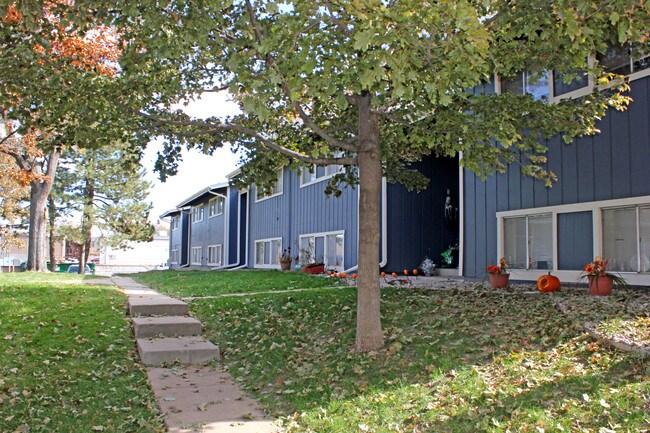
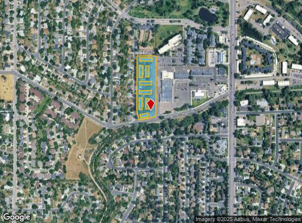
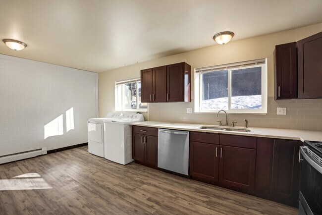
Property Record
6900 S Bannock St, Littleton, CO 80120

NEARBY LISTINGS FOR SALE OR LEASE
Property Detail
6900 S Bannock St
2077-27-2-22-001
Broadridge Plaza 2Nd Flg
Apartment
SUBDIVISIONCD 006700 SUBDIVISIONNAME BROADRIDGE PLAZA 2ND FLG BLOCK 002 LOT 000 BLKS 2 & 3 BROADRIDGE PLAZA 2ND FLG
X
Arapahoe
08005C0453L
Colorado
2023
2.97 AC
2024
Littleton
006603
Denver
67,955 SF
Denver-Aurora-Lakewood, CO
DEMOGRAPHICS near 6900 S Bannock St
1 Mile
3 Mile
5 Mile
2024 Total Population
12,936
96,304
263,144
2029 Population
12,979
98,582
273,062
Pop Growth 2024-2029
+ 0.33%
+ 2.37%
+ 3.77%
Average Age
43
43
42
2024 Total Households
5,093
41,100
106,290
HH Growth 2024-2029
+ 0.27%
+ 2.67%
+ 3.72%
Median Household Inc
$112,162
$98,105
$109,264
Avg Household Size
2.50
2.30
2.40
2024 Avg HH Vehicles
2.00
2.00
2.00
Median Home Value
$614,840
$615,892
$638,095
Median Year Built
1969
1979
1983
Nearby Places
Map Layers
Map Styles
 Street
 Aerial
- Restaurants
- Banks
- Shops
- Fitness
- Groceries
PUBLIC TRANSPORTATION
AIRPORT
Denver International
DRIVE
WALK
Distance
Denver International
44 min
34.5 mi
Freight Ports
Tulsa Port Of Catoosa
DRIVE
WALK
Distance
Tulsa Port Of Catoosa
739 min
721.7 mi
SALE & LEASE HISTORY
LISTING DATE
SALE/LEASE

Mar 22, 2022
For Sale
Jan 16, 2019
For Sale
Nearby Properties
Address
Land Use
TOTAL SIZE
Lot Size
Zoning
Address
Land Use
TOTAL SIZE
Lot Size
Zoning
571,212 SF
21.49 AC
Address
Land Use
TOTAL SIZE
Lot Size
Zoning
390,078 SF
38.27 AC
Address
Land Use
TOTAL SIZE
Lot Size
Zoning
187,769 SF
16.09 AC
Address
Land Use
TOTAL SIZE
Lot Size
Zoning
622,103 SF
24.61 AC
PDU
Address
Land Use
TOTAL SIZE
Lot Size
Zoning
251,583 SF
38.03 AC
Address
Land Use
TOTAL SIZE
Lot Size
Zoning
133,908 SF
9.39 AC
LPD-C
Address
Land Use
TOTAL SIZE
Lot Size
Zoning
1,639,172 SF
53.02 AC
Address
Land Use
TOTAL SIZE
Lot Size
Zoning
167,287 SF
13.65 AC
Address
Land Use
TOTAL SIZE
Lot Size
Zoning
150,767 SF
14.49 AC
PDU
Address
Land Use
TOTAL SIZE
Lot Size
Zoning
177,772 SF
16 AC
Address
Land Use
TOTAL SIZE
Lot Size
Zoning
484,245 SF
18.06 AC
Address
Land Use
TOTAL SIZE
Lot Size
Zoning
163,695 SF
22.90 AC
Address
Land Use
TOTAL SIZE
Lot Size
Zoning
329,937 SF
35.07 AC
PUD
Address
Land Use
TOTAL SIZE
Lot Size
Zoning
572,657 SF
0.21 AC
LPD-C
Address
Land Use
TOTAL SIZE
Lot Size
Zoning
411,924 SF
26.85 AC
LPDI
Address
Land Use
TOTAL SIZE
Lot Size
Zoning
192,108 SF
20.03 AC
Address
Land Use
TOTAL SIZE
Lot Size
Zoning
147,856 SF
5.49 AC
PDU
Address
Land Use
TOTAL SIZE
Lot Size
Zoning
47.24 AC
Address
Land Use
TOTAL SIZE
Lot Size
Zoning
7,035 SF
12.90 AC
LPD-R
Address
Land Use
TOTAL SIZE
Lot Size
Zoning
312,130 SF
20.63 AC
PDU
Address
Land Use
TOTAL SIZE
Lot Size
Zoning
290,636 SF
14.54 AC
PDU
Address
Land Use
TOTAL SIZE
Lot Size
Zoning
1,036,325 SF
51.26 AC
PDU
Address
Land Use
TOTAL SIZE
Lot Size
Zoning
250,402 SF
21 AC
Address
Land Use
TOTAL SIZE
Lot Size
Zoning
179,081 SF
6.79 AC
Address
Land Use
TOTAL SIZE
Lot Size
Zoning
206,632 SF
33.68 AC
Address
Land Use
TOTAL SIZE
Lot Size
Zoning
65,260 SF
11.15 AC
Address
Land Use
TOTAL SIZE
Lot Size
Zoning
61,607 SF
11.60 AC
LPD-C
Address
Land Use
TOTAL SIZE
Lot Size
Zoning
112,847 SF
8.08 AC
PDU
Address
Land Use
TOTAL SIZE
Lot Size
Zoning
463,840 SF
17.63 AC
PDU
Address
Land Use
TOTAL SIZE
Lot Size
Zoning
331,736 SF
The World's #1 Commercial Real Estate Marketplace
Connect with us
© 2025 CoStar Group
The information above has been obtained from sources believed reliable. While we do not doubt its accuracy we have not verified it and make no guarantee, warranty or representation about it. It is your responsibility to independently confirm its accuracy and completeness. Any projections, opinions, assumptions, or estimates used are for example only and do not represent the current or future performance of the property. The value of this transaction to you depends on tax and other factors which should be evaluated by your tax, financial, and legal advisors. You and your advisors should conduct a careful, independent investigation of the property to determine to your satisfaction the suitability of the property for your needs.