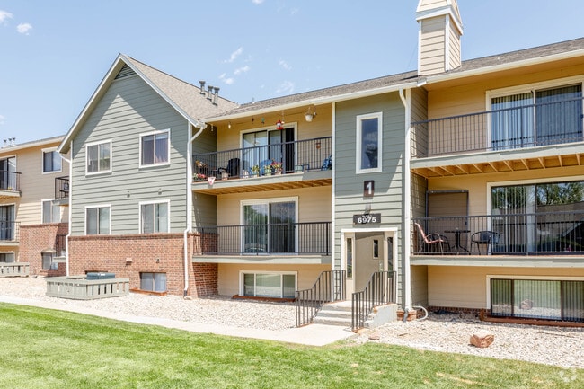
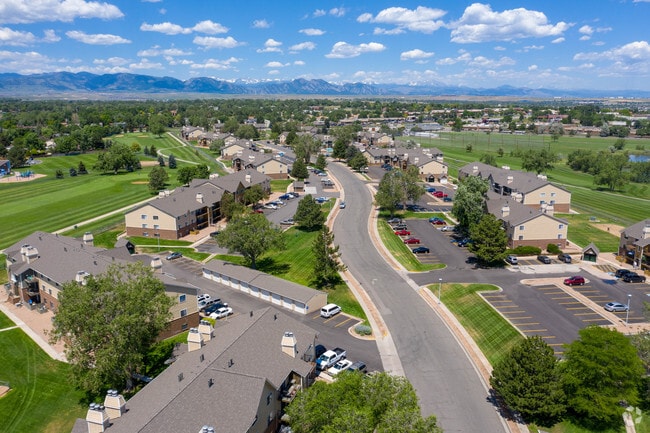
Property Record
6925 W 84Th Way, Arvada, CO 80003

Save to a Folder
{{folder.Name}}
{{folder.ListingIds.length}} Properties
{{folder.ListingIds.length}} Property
Create a New Folder
Property Detail
6925 W 84Th Way
29-261-00-001
SECTION 26 TOWNSHIP 02 RANGE 69 QTR NE SIZE: 1155081 VALUE: 26.517 KEY=034
Multifamilydwelling
JEFFERSON
A Areas with a 1% annual chance of flooding and a 26% chance of flooding over the life of a 30-year mortgage.
Colorado
0
26.52 AC
2025
Lake Arbor Fairways
009833
Denver
559,786 SF
Denver-Aurora-Centennial, CO
NEARBY LISTINGS FOR SALE OR LEASE
DEMOGRAPHICS near 6925 W 84Th Way
1 mile
3 mile
5 mile
2025 Total Population
15,166
113,519
308,440
2030 Population
15,089
113,961
312,889
Pop Growth 2025-2030
(0.51%)
+ 0.39%
+ 1.44%
Average Age
40
41
40
2025 Total Households
6,634
44,998
120,392
HH Growth 2025-2030
(0.41%)
+ 0.42%
+ 1.50%
Median Household Inc
$86,930
$96,846
$94,833
Avg Household Size
2.20
2.40
2.50
2025 Avg HH Vehicles
2.00
2.00
2.00
Median Home Value
$484,388
$581,763
$566,207
Median Year Built
1978
1977
1979
Nearby Places
Map Layers
Map Styles
 Street
 Aerial
Layers
 Traffic
 Biking
Places
Listings with unknown addresses are not visible on the map
- Restaurants
- Banks
- Shops
- Fitness
- Groceries
PUBLIC TRANSPORTATION
COMMUTER RAIL
Westminster Station N-Bound (Union Station to Westminster Station - Regional Transportation District)
Drive
Walk
Distance
Westminster Station N-Bound (Union Station to Westminster Station - Regional Transportation District)
10 min
4.0 mi
Westminster Station S-Bound (Union Station to Westminster Station - Regional Transportation District)
Drive
Walk
Distance
Westminster Station S-Bound (Union Station to Westminster Station - Regional Transportation District)
10 min
4.3 mi
AIRPORT
Denver International
Drive
Walk
Distance
Denver International
40 min
30.2 mi
Freight Ports
Tulsa Port Of Catoosa
Drive
Walk
Distance
Tulsa Port Of Catoosa
737 min
715.7 mi
Nearby Properties
Address
Land Use
TOTAL SIZE
Lot Size
Zoning
Address
Land Use
TOTAL SIZE
Lot Size
Zoning
21,306 SF
2.43 AC
Address
Land Use
TOTAL SIZE
Lot Size
Zoning
248,096 SF
19.67 AC
Address
Land Use
TOTAL SIZE
Lot Size
Zoning
224,600 SF
6.22 AC
Address
Land Use
TOTAL SIZE
Lot Size
Zoning
216,285 SF
6 AC
Address
Land Use
TOTAL SIZE
Lot Size
Zoning
208,500 SF
8.42 AC
Address
Land Use
TOTAL SIZE
Lot Size
Zoning
176,583 SF
Address
Land Use
TOTAL SIZE
Lot Size
Zoning
117,774 SF
8.60 AC
Address
Land Use
TOTAL SIZE
Lot Size
Zoning
138,912 SF
8.71 AC
Address
Land Use
TOTAL SIZE
Lot Size
Zoning
81,065 SF
4.51 AC
Address
Land Use
TOTAL SIZE
Lot Size
Zoning
113,385 SF
6.77 AC
Address
Land Use
TOTAL SIZE
Lot Size
Zoning
398,180 SF
33.31 AC
R1C
Address
Land Use
TOTAL SIZE
Lot Size
Zoning
58,750 SF
1.52 AC
Address
Land Use
TOTAL SIZE
Lot Size
Zoning
305,110 SF
16.87 AC
Address
Land Use
TOTAL SIZE
Lot Size
Zoning
52,194 SF
5.33 AC
Address
Land Use
TOTAL SIZE
Lot Size
Zoning
209,009 SF
22.30 AC
Address
Land Use
TOTAL SIZE
Lot Size
Zoning
64,106 SF
4.10 AC
Address
Land Use
TOTAL SIZE
Lot Size
Zoning
46,922 SF
2.35 AC
Address
Land Use
TOTAL SIZE
Lot Size
Zoning
29,986 SF
2.88 AC
Address
Land Use
TOTAL SIZE
Lot Size
Zoning
75,062 SF
5.28 AC
A1
Address
Land Use
TOTAL SIZE
Lot Size
Zoning
674,481 SF
21.06 AC
Address
Land Use
TOTAL SIZE
Lot Size
Zoning
71,682 SF
4.14 AC
Address
Land Use
TOTAL SIZE
Lot Size
Zoning
62,025 SF
2.49 AC
R4
Address
Land Use
TOTAL SIZE
Lot Size
Zoning
250,701 SF
14.14 AC
Address
Land Use
TOTAL SIZE
Lot Size
Zoning
25,016 SF
3.10 AC
Address
Land Use
TOTAL SIZE
Lot Size
Zoning
310,000 SF
26.51 AC
Address
Land Use
TOTAL SIZE
Lot Size
Zoning
121,639 SF
25.99 AC
Address
Land Use
TOTAL SIZE
Lot Size
Zoning
155,081 SF
7.42 AC
Address
Land Use
TOTAL SIZE
Lot Size
Zoning
361,013 SF
2.88 AC
Address
Land Use
TOTAL SIZE
Lot Size
Zoning
91,818 SF
3.38 AC
The World's #1 Commercial Real Estate Marketplace
Connect with us
© 2026 CoStar Group
The information above has been obtained from sources believed reliable. While we do not doubt its accuracy we have not verified it and make no guarantee, warranty or representation about it. It is your responsibility to independently confirm its accuracy and completeness. Any projections, opinions, assumptions, or estimates used are for example only and do not represent the current or future performance of the property. The value of this transaction to you depends on tax and other factors which should be evaluated by your tax, financial, and legal advisors. You and your advisors should conduct a careful, independent investigation of the property to determine to your satisfaction the suitability of the property for your needs.