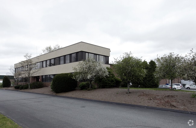
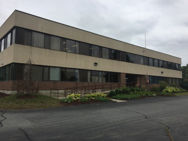
Property Record
705 Myles Standish Blvd, Taunton, MA 02780


Current Lease Availabilities
NEARBY LISTINGS FOR SALE OR LEASE
Property Detail
705 Myles Standish Blvd
TAUN-000014-000006
Bristol
Industrialgeneral
Massachusetts
X
6
25005C0134F
6.89 AC
2024
Attleboro/New Bedford
2025
Boston
613100
Providence-Warwick, RI-MA
DEMOGRAPHICS near 705 Myles Standish Blvd
1 Mile
3 Mile
5 Mile
2024 Total Population
733
18,172
71,698
2029 Population
729
17,976
71,196
Pop Growth 2024-2029
(0.55%)
(1.08%)
(0.70%)
Average Age
45
42
41
2024 Total Households
293
6,916
27,800
HH Growth 2024-2029
(0.68%)
(1.06%)
(0.71%)
Median Household Inc
$118,518
$90,864
$81,689
Avg Household Size
2.40
2.50
2.50
2024 Avg HH Vehicles
2.00
2.00
2.00
Median Home Value
$441,176
$402,634
$412,020
Median Year Built
1981
1975
1973
Nearby Places
Map Layers
Map Styles
 Street
 Aerial
- Restaurants
- Banks
- Shops
- Fitness
- Groceries
PUBLIC TRANSPORTATION
COMMUTER RAIL
Mansfield (Foxboro Line (Special Events Only) - Massachusetts Bay Transportation Authority Commuter Rail (Purple Line), Providence/Stoughton Line - Massachusetts Bay Transportation Authority Commuter Rail (Purple Line))
DRIVE
WALK
Distance
Mansfield (Foxboro Line (Special Events Only) - Massachusetts Bay Transportation Authority Commuter Rail (Purple Line), Providence/Stoughton Line - Massachusetts Bay Transportation Authority Commuter Rail (Purple Line))
16 min
9.5 mi
AIRPORT
Rhode Island Tf Green International
DRIVE
WALK
Distance
Rhode Island Tf Green International
52 min
29.0 mi
General Edward Lawrence Logan International
DRIVE
WALK
Distance
General Edward Lawrence Logan International
54 min
38.0 mi
Freight Ports
Port of New Bedford Harbor
DRIVE
WALK
Distance
Port of New Bedford Harbor
42 min
31.7 mi
Nearby Properties
Address
Land Use
TOTAL SIZE
Lot Size
Zoning
Address
Land Use
TOTAL SIZE
Lot Size
Zoning
68,024 SF
66.24 AC
RURRES
Address
Land Use
TOTAL SIZE
Lot Size
Zoning
559,641 SF
73.61 AC
Address
Land Use
TOTAL SIZE
Lot Size
Zoning
3,838 SF
1.11 AC
R80
Address
Land Use
TOTAL SIZE
Lot Size
Zoning
486,363 SF
41.18 AC
INDUST
Address
Land Use
TOTAL SIZE
Lot Size
Zoning
604,133 SF
42.73 AC
Address
Land Use
TOTAL SIZE
Lot Size
Zoning
223,480 SF
37.59 AC
Address
Land Use
TOTAL SIZE
Lot Size
Zoning
315,896 SF
24.53 AC
INDUST
Address
Land Use
TOTAL SIZE
Lot Size
Zoning
225,600 SF
18.47 AC
R80
Address
Land Use
TOTAL SIZE
Lot Size
Zoning
335,092 SF
27.12 AC
INDUST
Address
Land Use
TOTAL SIZE
Lot Size
Zoning
681,295 SF
65.93 AC
Address
Land Use
TOTAL SIZE
Lot Size
Zoning
212,672 SF
34.40 AC
Address
Land Use
TOTAL SIZE
Lot Size
Zoning
201,634 SF
12.01 AC
Address
Land Use
TOTAL SIZE
Lot Size
Zoning
361,737 SF
20 AC
INDUST
Address
Land Use
TOTAL SIZE
Lot Size
Zoning
25.26 AC
INDUST
Address
Land Use
TOTAL SIZE
Lot Size
Zoning
Address
Land Use
TOTAL SIZE
Lot Size
Zoning
123,740 SF
10.67 AC
R80
Address
Land Use
TOTAL SIZE
Lot Size
Zoning
160,798 SF
14.31 AC
INDUST
Address
Land Use
TOTAL SIZE
Lot Size
Zoning
196,420 SF
21.78 AC
INDUST
Address
Land Use
TOTAL SIZE
Lot Size
Zoning
213,128 SF
12 AC
INDUST
Address
Land Use
TOTAL SIZE
Lot Size
Zoning
200,000 SF
14.56 AC
INDUST
Address
Land Use
TOTAL SIZE
Lot Size
Zoning
26.70 AC
Address
Land Use
TOTAL SIZE
Lot Size
Zoning
153,057 SF
13.96 AC
INDUST
Address
Land Use
TOTAL SIZE
Lot Size
Zoning
239,923 SF
14.24 AC
INDUST
Address
Land Use
TOTAL SIZE
Lot Size
Zoning
217,814 SF
11.30 AC
INDUST
Address
Land Use
TOTAL SIZE
Lot Size
Zoning
198,720 SF
15.10 AC
INDUST
Address
Land Use
TOTAL SIZE
Lot Size
Zoning
36,336 SF
6.35 AC
RURRES
Address
Land Use
TOTAL SIZE
Lot Size
Zoning
32.93 AC
BIZDIS
Address
Land Use
TOTAL SIZE
Lot Size
Zoning
114,057 SF
6.43 AC
INDUST
Address
Land Use
TOTAL SIZE
Lot Size
Zoning
191,828 SF
17.09 AC
INDUST
Address
Land Use
TOTAL SIZE
Lot Size
Zoning
163,752 SF
28.17 AC
INDUST
The World's #1 Commercial Real Estate Marketplace
Connect with us
© 2025 CoStar Group
The information above has been obtained from sources believed reliable. While we do not doubt its accuracy we have not verified it and make no guarantee, warranty or representation about it. It is your responsibility to independently confirm its accuracy and completeness. Any projections, opinions, assumptions, or estimates used are for example only and do not represent the current or future performance of the property. The value of this transaction to you depends on tax and other factors which should be evaluated by your tax, financial, and legal advisors. You and your advisors should conduct a careful, independent investigation of the property to determine to your satisfaction the suitability of the property for your needs.