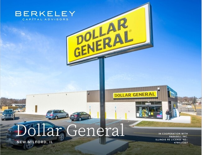
Property Record
6973 11Th St, Rockford, IL 61109

NEARBY LISTINGS FOR SALE OR LEASE
-
-
View all Rockford listings for sale on LoopNet.com
Property Detail
6973 11Th St
Rockford, IL
New Milford Dg Sub
15-24-355-014
NEW MILFORD DG SUB PT SW1/4 SEC 24-43-1 LT 1
Commercialnec
Winnebago
2024
Illinois
2024
1
003711
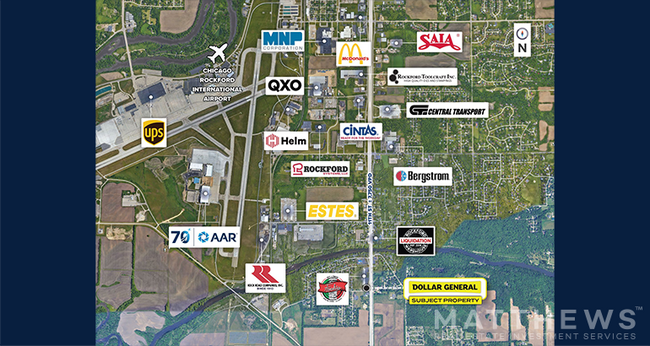
I-39 Corr/Winnebago Cnty
9,230 SF
Chicago
DEMOGRAPHICS near 6973 11Th St
1 Mile
3 Mile
5 Mile
2024 Total Population
1,835
8,931
40,734
2029 Population
1,833
8,804
40,209
Pop Growth 2024-2029
(0.11%)
(1.42%)
(1.29%)
Average Age
46
43
38
2024 Total Households
778
3,549
16,435
HH Growth 2024-2029
0.00%
(1.35%)
(1.27%)
Median Household Inc
$63,446
$65,151
$46,193
Avg Household Size
2.30
2.50
2.40
2024 Avg HH Vehicles
2.00
2.00
2.00
Median Home Value
$141,065
$138,143
$102,009
Median Year Built
1975
1976
1967
Nearby Places
Map Layers
Map Styles
 Street
 Aerial
- Restaurants
- Banks
- Shops
- Fitness
- Groceries
PUBLIC TRANSPORTATION
AIRPORT
Chicago/Rockford International
DRIVE
WALK
Distance
Chicago/Rockford International
8 min
2.7 mi
Freight Ports
Port Milwaukee
DRIVE
WALK
Distance
Port Milwaukee
117 min
99.8 mi
SALE & LEASE HISTORY
LISTING DATE
SALE/LEASE

Jun 23, 2025
For Sale
Jul 27, 2022
For Sale
Nearby Properties
Address
Land Use
TOTAL SIZE
Lot Size
Zoning
Address
Land Use
TOTAL SIZE
Lot Size
Zoning
555,920 SF
37.99 AC
I2
Address
Land Use
TOTAL SIZE
Lot Size
Zoning
369,006 SF
15.24 AC
I2
Address
Land Use
TOTAL SIZE
Lot Size
Zoning
291,074 SF
10.97 AC
I3
Address
Land Use
TOTAL SIZE
Lot Size
Zoning
189,455 SF
10.99 AC
I3
Address
Land Use
TOTAL SIZE
Lot Size
Zoning
173,193 SF
5.97 AC
I3
Address
Land Use
TOTAL SIZE
Lot Size
Zoning
192,476 SF
30.63 AC
I2
Address
Land Use
TOTAL SIZE
Lot Size
Zoning
623,379 SF
35.15 AC
I3
Address
Land Use
TOTAL SIZE
Lot Size
Zoning
2,393 SF
159.54 AC
Address
Land Use
TOTAL SIZE
Lot Size
Zoning
212,574 SF
9.57 AC
I3
Address
Land Use
TOTAL SIZE
Lot Size
Zoning
150,351 SF
22.95 AC
I3
Address
Land Use
TOTAL SIZE
Lot Size
Zoning
584,794 SF
34.40 AC
I3
Address
Land Use
TOTAL SIZE
Lot Size
Zoning
152,100 SF
4.19 AC
I2
Address
Land Use
TOTAL SIZE
Lot Size
Zoning
216,549 SF
9.18 AC
I2
Address
Land Use
TOTAL SIZE
Lot Size
Zoning
6,869 SF
93.78 AC
RMH
Address
Land Use
TOTAL SIZE
Lot Size
Zoning
187,025 SF
12.82 AC
I3
Address
Land Use
TOTAL SIZE
Lot Size
Zoning
92,245 SF
5.67 AC
I3
Address
Land Use
TOTAL SIZE
Lot Size
Zoning
206,185 SF
21.09 AC
I3
Address
Land Use
TOTAL SIZE
Lot Size
Zoning
165,326 SF
26.32 AC
I3
Address
Land Use
TOTAL SIZE
Lot Size
Zoning
203,450 SF
31.79 AC
I3
Address
Land Use
TOTAL SIZE
Lot Size
Zoning
88.14 AC
Address
Land Use
TOTAL SIZE
Lot Size
Zoning
79,779 SF
17.50 AC
I2
Address
Land Use
TOTAL SIZE
Lot Size
Zoning
102,065 SF
9.50 AC
I2
Address
Land Use
TOTAL SIZE
Lot Size
Zoning
94,386 SF
4.89 AC
I3
Address
Land Use
TOTAL SIZE
Lot Size
Zoning
78,334 SF
9.78 AC
I3
Address
Land Use
TOTAL SIZE
Lot Size
Zoning
113,295 SF
6.42 AC
I3
Address
Land Use
TOTAL SIZE
Lot Size
Zoning
76,800 SF
5 AC
I3
Address
Land Use
TOTAL SIZE
Lot Size
Zoning
214,625 SF
18.66 AC
I3
Address
Land Use
TOTAL SIZE
Lot Size
Zoning
66,169 SF
3.11 AC
I3
Address
Land Use
TOTAL SIZE
Lot Size
Zoning
38,945 SF
10.02 AC
I3
Address
Land Use
TOTAL SIZE
Lot Size
Zoning
37,115 SF
42.96 AC
I1
The World's #1 Commercial Real Estate Marketplace
Connect with us
© 2025 CoStar Group
The information above has been obtained from sources believed reliable. While we do not doubt its accuracy we have not verified it and make no guarantee, warranty or representation about it. It is your responsibility to independently confirm its accuracy and completeness. Any projections, opinions, assumptions, or estimates used are for example only and do not represent the current or future performance of the property. The value of this transaction to you depends on tax and other factors which should be evaluated by your tax, financial, and legal advisors. You and your advisors should conduct a careful, independent investigation of the property to determine to your satisfaction the suitability of the property for your needs.