Property Record
700 Alta Vista Dr, Vista, CA 92084


Save to a Folder
{{folder.Name}}
{{folder.ListingIds.length}} Properties
{{folder.ListingIds.length}} Property
Create a New Folder
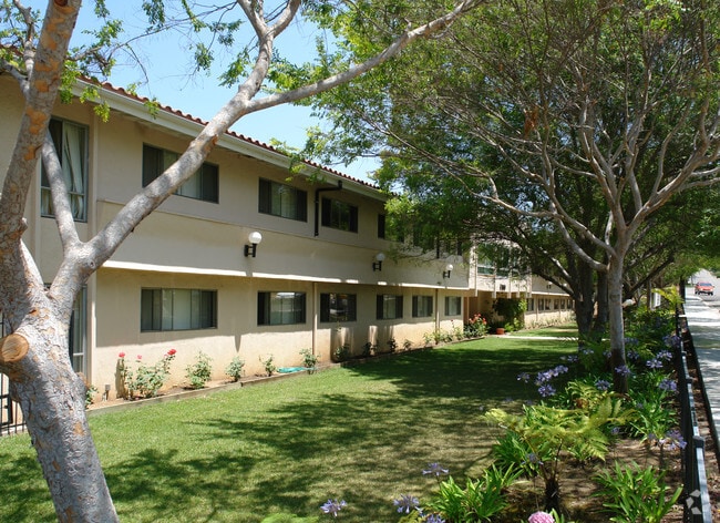
Property Detail
700 Alta Vista Dr
176-060-33
PAR C TR PM06958
Multifamilydwelling
San Diego
R-M
California
B and X Area of moderate flood hazard, usually the area between the limits of the 100-year and 500-year floods.
1.13 AC
2025
Vista
2025
San Diego
019601
San Diego-Chula Vista-Carlsbad, CA
26,980 SF
NEARBY LISTINGS FOR SALE OR LEASE
DEMOGRAPHICS near 700 Alta Vista Dr
1 mile
3 mile
5 mile
2025 Total Population
27,308
123,582
230,780
2030 Population
27,627
124,304
231,492
Pop Growth 2025-2030
+ 1.17%
+ 0.58%
+ 0.31%
Average Age
36
39
40
2025 Total Households
7,584
39,936
77,331
HH Growth 2025-2030
+ 1.08%
+ 0.42%
+ 0.17%
Median Household Inc
$88,681
$98,811
$103,768
Avg Household Size
3.40
3.00
2.90
2025 Avg HH Vehicles
2.00
2.00
2.00
Median Home Value
$705,273
$761,289
$770,584
Median Year Built
1974
1982
1984
Nearby Places
Map Layers
Map Styles
 Street
 Aerial
Layers
 Traffic
 Biking
Places
Listings with unknown addresses are not visible on the map
- Restaurants
- Banks
- Shops
- Fitness
- Groceries
PUBLIC TRANSPORTATION
TRANSIT/SUBWAY
Vista Transit Center (Sprinter - San Diego North County Transit District (Coaster/Sprinter/Breeze))
Drive
Walk
Distance
Vista Transit Center (Sprinter - San Diego North County Transit District (Coaster/Sprinter/Breeze))
2 min
16 min
0.8 mi
COMMUTER RAIL
Carlsbad Village (Coaster - San Diego North County Transit District (Coaster/Sprinter/Breeze))
Drive
Walk
Distance
Carlsbad Village (Coaster - San Diego North County Transit District (Coaster/Sprinter/Breeze))
15 min
9.1 mi
AIRPORT
San Diego International
Drive
Walk
Distance
San Diego International
52 min
41.1 mi
Nearby Properties
Address
Land Use
TOTAL SIZE
Lot Size
Zoning
Address
Land Use
TOTAL SIZE
Lot Size
Zoning
24.15 AC
RM-B
Address
Land Use
TOTAL SIZE
Lot Size
Zoning
20.10 AC
M-U
Address
Land Use
TOTAL SIZE
Lot Size
Zoning
10.39 AC
M-U (40)
Address
Land Use
TOTAL SIZE
Lot Size
Zoning
18.90 AC
R-M
Address
Land Use
TOTAL SIZE
Lot Size
Zoning
11.17 AC
M-U
Address
Land Use
TOTAL SIZE
Lot Size
Zoning
21.44 AC
C-1
Address
Land Use
TOTAL SIZE
Lot Size
Zoning
9,999 SF
1.23 AC
SPI
Address
Land Use
TOTAL SIZE
Lot Size
Zoning
7.97 AC
SPI-DV
Address
Land Use
TOTAL SIZE
Lot Size
Zoning
7.57 AC
R-M
Address
Land Use
TOTAL SIZE
Lot Size
Zoning
14.91 AC
SPI
Address
Land Use
TOTAL SIZE
Lot Size
Zoning
5.10 AC
R-M
Address
Land Use
TOTAL SIZE
Lot Size
Zoning
9.48 AC
R-M
Address
Land Use
TOTAL SIZE
Lot Size
Zoning
14.08 AC
RH
Address
Land Use
TOTAL SIZE
Lot Size
Zoning
8.67 AC
R-M
Address
Land Use
TOTAL SIZE
Lot Size
Zoning
10.38 AC
R-M
Address
Land Use
TOTAL SIZE
Lot Size
Zoning
6.55 AC
R-M
Address
Land Use
TOTAL SIZE
Lot Size
Zoning
7.33 AC
R-M
Address
Land Use
TOTAL SIZE
Lot Size
Zoning
9.11 AC
SPI
Address
Land Use
TOTAL SIZE
Lot Size
Zoning
3.32 AC
SPI
Address
Land Use
TOTAL SIZE
Lot Size
Zoning
10.59 AC
RH
Address
Land Use
TOTAL SIZE
Lot Size
Zoning
3.99 AC
M-U
Address
Land Use
TOTAL SIZE
Lot Size
Zoning
1.92 AC
C-2
Address
Land Use
TOTAL SIZE
Lot Size
Zoning
25.57 AC
C-2
Address
Land Use
TOTAL SIZE
Lot Size
Zoning
4.34 AC
SP-08
Address
Land Use
TOTAL SIZE
Lot Size
Zoning
12 AC
SPI
Address
Land Use
TOTAL SIZE
Lot Size
Zoning
74,866 SF
3.18 AC
C-1
Address
Land Use
TOTAL SIZE
Lot Size
Zoning
7.18 AC
R-M
Address
Land Use
TOTAL SIZE
Lot Size
Zoning
99,906 SF
5.06 AC
R-M
Address
Land Use
TOTAL SIZE
Lot Size
Zoning
14.67 AC
R-M
Address
Land Use
TOTAL SIZE
Lot Size
Zoning
59,481 SF
2.63 AC
C-1
The World's #1 Commercial Real Estate Marketplace
Connect with us
© 2026 CoStar Group
The information above has been obtained from sources believed reliable. While we do not doubt its accuracy we have not verified it and make no guarantee, warranty or representation about it. It is your responsibility to independently confirm its accuracy and completeness. Any projections, opinions, assumptions, or estimates used are for example only and do not represent the current or future performance of the property. The value of this transaction to you depends on tax and other factors which should be evaluated by your tax, financial, and legal advisors. You and your advisors should conduct a careful, independent investigation of the property to determine to your satisfaction the suitability of the property for your needs.