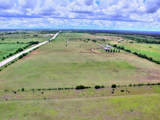
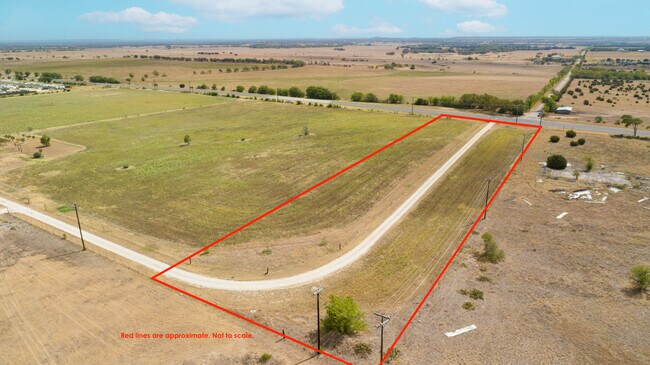
Property Record
890 N Highway 183, Florence, TX 76527

Property Detail
890 N Highway 183
73929
ABS A0446 H.T. & B.R.R.CO., 13.48 ACRES
Agriculturalland
BURNET
B and X Area of moderate flood hazard, usually the area between the limits of the 100-year and 500-year floods.
Texas
2024
13.48 AC
2025
Texas Hill Country
960101
Other Market Areas
NEARBY LISTINGS FOR SALE OR LEASE
DEMOGRAPHICS near 890 N Highway 183
1 mile
3 mile
5 mile
2025 Total Population
106
1,154
2,543
2030 Population
118
1,285
2,833
Pop Growth 2025-2030
+ 11.32%
+ 11.35%
+ 11.40%
Average Age
41
41
41
2025 Total Households
36
397
874
HH Growth 2025-2030
+ 13.89%
+ 11.84%
+ 11.56%
Median Household Inc
$110,714
$109,888
$104,133
Avg Household Size
2.90
2.80
2.80
2025 Avg HH Vehicles
3.00
3.00
3.00
Median Home Value
$410,000
$432,353
$443,478
Median Year Built
2002
2002
2002
Nearby Places
Map Layers
Map Styles
 Street
 Aerial
Layers
 Traffic
 Biking
Places
Listings with unknown addresses are not visible on the map
- Restaurants
- Banks
- Shops
- Fitness
- Groceries
PUBLIC TRANSPORTATION
AIRPORT
Robert Gray AAF
Drive
Walk
Distance
Robert Gray AAF
32 min
20.9 mi
Killeen Municipal
Drive
Walk
Distance
Killeen Municipal
40 min
31.8 mi
SALE & LEASE HISTORY
LISTING DATE
SALE/LEASE

Nov 07, 2017
For Sale
Aug 03, 2022
For Sale
Nearby Properties
Address
Land Use
TOTAL SIZE
Lot Size
Zoning
Address
Land Use
TOTAL SIZE
Lot Size
Zoning
194,550 SF
199 AC
Address
Land Use
TOTAL SIZE
Lot Size
Zoning
3,618 SF
11.47 AC
Address
Land Use
TOTAL SIZE
Lot Size
Zoning
13,200 SF
40.04 AC
Address
Land Use
TOTAL SIZE
Lot Size
Zoning
9,744 SF
5 AC
Address
Land Use
TOTAL SIZE
Lot Size
Zoning
7,669 SF
10 AC
Address
Land Use
TOTAL SIZE
Lot Size
Zoning
10,242 SF
57.72 AC
Address
Land Use
TOTAL SIZE
Lot Size
Zoning
7,500 SF
5 AC
Address
Land Use
TOTAL SIZE
Lot Size
Zoning
3,164 SF
5 AC
Address
Land Use
TOTAL SIZE
Lot Size
Zoning
12,160 SF
50 AC
Address
Land Use
TOTAL SIZE
Lot Size
Zoning
38.81 AC
Address
Land Use
TOTAL SIZE
Lot Size
Zoning
10,660 SF
1.97 AC
Address
Land Use
TOTAL SIZE
Lot Size
Zoning
57 AC
Address
Land Use
TOTAL SIZE
Lot Size
Zoning
36,413 SF
20.79 AC
Address
Land Use
TOTAL SIZE
Lot Size
Zoning
42.95 AC
Address
Land Use
TOTAL SIZE
Lot Size
Zoning
6,000 SF
4 AC
Address
Land Use
TOTAL SIZE
Lot Size
Zoning
6,000 SF
18.82 AC
Address
Land Use
TOTAL SIZE
Lot Size
Zoning
8,352 SF
4.99 AC
Address
Land Use
TOTAL SIZE
Lot Size
Zoning
4,271 SF
73.49 AC
Address
Land Use
TOTAL SIZE
Lot Size
Zoning
3,420 SF
22.24 AC
Address
Land Use
TOTAL SIZE
Lot Size
Zoning
3,888 SF
2.02 AC
Address
Land Use
TOTAL SIZE
Lot Size
Zoning
23.08 AC
Address
Land Use
TOTAL SIZE
Lot Size
Zoning
4,026 SF
5 AC
Address
Land Use
TOTAL SIZE
Lot Size
Zoning
53.07 AC
Address
Land Use
TOTAL SIZE
Lot Size
Zoning
3,200 SF
5 AC
Address
Land Use
TOTAL SIZE
Lot Size
Zoning
6,000 SF
1.79 AC
Address
Land Use
TOTAL SIZE
Lot Size
Zoning
20.15 AC
Address
Land Use
TOTAL SIZE
Lot Size
Zoning
14.82 AC
Address
Land Use
TOTAL SIZE
Lot Size
Zoning
4,800 SF
11.48 AC
Address
Land Use
TOTAL SIZE
Lot Size
Zoning
1,823 SF
64.98 AC
Address
Land Use
TOTAL SIZE
Lot Size
Zoning
3,725 SF
54.32 AC
The World's #1 Commercial Real Estate Marketplace
Connect with us
© 2026 CoStar Group
The information above has been obtained from sources believed reliable. While we do not doubt its accuracy we have not verified it and make no guarantee, warranty or representation about it. It is your responsibility to independently confirm its accuracy and completeness. Any projections, opinions, assumptions, or estimates used are for example only and do not represent the current or future performance of the property. The value of this transaction to you depends on tax and other factors which should be evaluated by your tax, financial, and legal advisors. You and your advisors should conduct a careful, independent investigation of the property to determine to your satisfaction the suitability of the property for your needs.