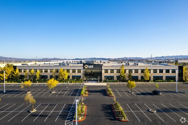
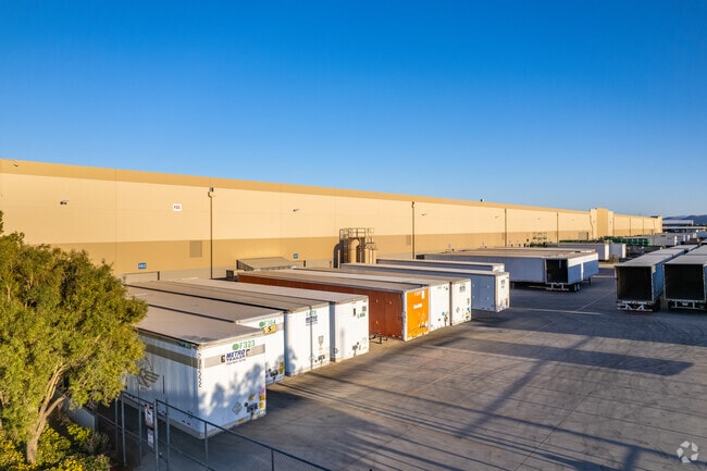
Property Record
7000 Lindell Rd, Las Vegas, NV 89118


Property Detail
7000 Lindell Rd
176-01-701-027
PARCEL MAP FILE 127 PAGE 15 LOT 1
Shipyard
Clark
MD
Nevada
C and X Area of minimal flood hazard, usually depicted on FIRMs as above the 500-year flood level.
1
2026
53.28 AC
2026
Southwest Las Vegas
002979
Las Vegas
930,204 SF
Las Vegas-Henderson-North Las Vegas, NV
NEARBY LISTINGS FOR SALE OR LEASE
DEMOGRAPHICS near 7000 Lindell Rd
1 mile
3 mile
5 mile
2025 Total Population
11,630
103,648
368,159
2030 Population
12,185
109,691
389,984
Pop Growth 2025-2030
+ 4.77%
+ 5.83%
+ 5.93%
Average Age
37
39
40
2025 Total Households
4,108
38,669
144,874
HH Growth 2025-2030
+ 4.70%
+ 5.73%
+ 5.96%
Median Household Inc
$87,671
$82,776
$78,766
Avg Household Size
2.80
2.60
2.50
2025 Avg HH Vehicles
2.00
2.00
2.00
Median Home Value
$409,227
$474,566
$458,609
Median Year Built
2005
2002
2001
Nearby Places
Map Layers
Map Styles
 Street
 Aerial
Layers
 Traffic
 Biking
Places
Listings with unknown addresses are not visible on the map
- Restaurants
- Banks
- Shops
- Fitness
- Groceries
PUBLIC TRANSPORTATION
AIRPORT
Harry Reid International
Drive
Walk
Distance
Harry Reid International
10 min
6.2 mi
Boulder City Municipal
Drive
Walk
Distance
Boulder City Municipal
35 min
25.9 mi
Freight Ports
Port of Long Beach
Drive
Walk
Distance
Port of Long Beach
312 min
277.8 mi
SALE & LEASE HISTORY
LISTING DATE
SALE/LEASE

Mar 28, 2022
For Lease
Nearby Properties
Address
Land Use
TOTAL SIZE
Lot Size
Zoning
Address
Land Use
TOTAL SIZE
Lot Size
Zoning
2,000,377 SF
118.89 AC
Address
Land Use
TOTAL SIZE
Lot Size
Zoning
937,376 SF
59.19 AC
Address
Land Use
TOTAL SIZE
Lot Size
Zoning
764,918 SF
94.41 AC
H1
Address
Land Use
TOTAL SIZE
Lot Size
Zoning
321,990 SF
76.15 AC
PF
Address
Land Use
TOTAL SIZE
Lot Size
Zoning
412,086 SF
33.58 AC
CP
Address
Land Use
TOTAL SIZE
Lot Size
Zoning
391,021 SF
40.14 AC
Address
Land Use
TOTAL SIZE
Lot Size
Zoning
35.25 AC
MD
Address
Land Use
TOTAL SIZE
Lot Size
Zoning
760,651 SF
41.25 AC
Address
Land Use
TOTAL SIZE
Lot Size
Zoning
257,910 SF
31.47 AC
Address
Land Use
TOTAL SIZE
Lot Size
Zoning
21,257 SF
12.72 AC
Address
Land Use
TOTAL SIZE
Lot Size
Zoning
66.26 AC
RE
Address
Land Use
TOTAL SIZE
Lot Size
Zoning
317,500 SF
19.26 AC
Address
Land Use
TOTAL SIZE
Lot Size
Zoning
353,690 SF
17.23 AC
Address
Land Use
TOTAL SIZE
Lot Size
Zoning
262,750 SF
17.95 AC
Address
Land Use
TOTAL SIZE
Lot Size
Zoning
6,142 SF
13.96 AC
C2
Address
Land Use
TOTAL SIZE
Lot Size
Zoning
222,625 SF
16.99 AC
Address
Land Use
TOTAL SIZE
Lot Size
Zoning
374,101 SF
31.11 AC
Address
Land Use
TOTAL SIZE
Lot Size
Zoning
396,742 SF
17.10 AC
Address
Land Use
TOTAL SIZE
Lot Size
Zoning
239,500 SF
13.18 AC
Address
Land Use
TOTAL SIZE
Lot Size
Zoning
10,869 SF
14.77 AC
Address
Land Use
TOTAL SIZE
Lot Size
Zoning
764,886 SF
26.61 AC
M1
Address
Land Use
TOTAL SIZE
Lot Size
Zoning
9.34 AC
Address
Land Use
TOTAL SIZE
Lot Size
Zoning
4,830 SF
15.84 AC
Address
Land Use
TOTAL SIZE
Lot Size
Zoning
4,199 SF
12.11 AC
RE
Address
Land Use
TOTAL SIZE
Lot Size
Zoning
220,718 SF
3.99 AC
C2
Address
Land Use
TOTAL SIZE
Lot Size
Zoning
6,782 SF
17.45 AC
R3
Address
Land Use
TOTAL SIZE
Lot Size
Zoning
478,844 SF
35.21 AC
MD
Address
Land Use
TOTAL SIZE
Lot Size
Zoning
445,028 SF
33.78 AC
The World's #1 Commercial Real Estate Marketplace
Connect with us
© 2026 CoStar Group
The information above has been obtained from sources believed reliable. While we do not doubt its accuracy we have not verified it and make no guarantee, warranty or representation about it. It is your responsibility to independently confirm its accuracy and completeness. Any projections, opinions, assumptions, or estimates used are for example only and do not represent the current or future performance of the property. The value of this transaction to you depends on tax and other factors which should be evaluated by your tax, financial, and legal advisors. You and your advisors should conduct a careful, independent investigation of the property to determine to your satisfaction the suitability of the property for your needs.