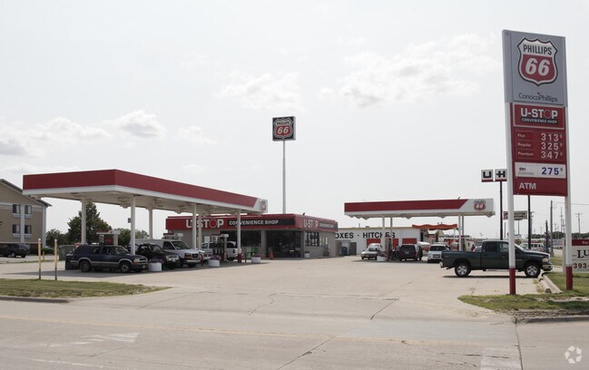
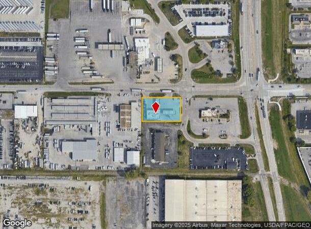
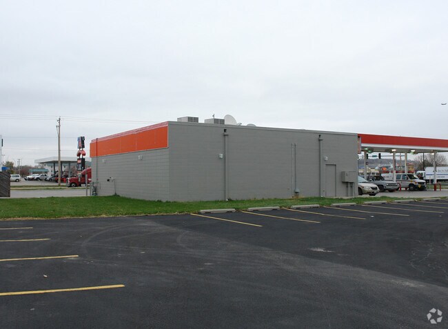
Property Record
701 32Nd Ave, Council Bluffs, IA 51501
NEARBY LISTINGS FOR SALE OR LEASE
Property Detail
701 32Nd Ave
Omaha-Council Bluffs, NE-IA
Coats Subdivision
7444-12-178-002
COATS SUB LT 3
Conveniencestore
Pottawattamie
X
Iowa
31153C0125G
3
2025
0.72 AC
2025
Council Bluffs
031300
Omaha/Council Bluffs
2,403 SF
DEMOGRAPHICS near 701 32Nd Ave
1 Mile
3 Mile
5 Mile
2024 Total Population
3,266
37,609
101,157
2029 Population
3,237
37,507
101,584
Pop Growth 2024-2029
(0.89%)
(0.27%)
+ 0.42%
Average Age
42
40
39
2024 Total Households
1,304
15,346
39,354
HH Growth 2024-2029
(0.84%)
(0.29%)
+ 0.52%
Median Household Inc
$54,673
$58,317
$60,180
Avg Household Size
2.40
2.40
2.40
2024 Avg HH Vehicles
2.00
2.00
2.00
Median Home Value
$126,659
$156,898
$163,455
Median Year Built
1966
1961
1958
Nearby Places
Map Layers
Map Styles
 Street
 Aerial
- Restaurants
- Banks
- Shops
- Fitness
- Groceries
PUBLIC TRANSPORTATION
COMMUTER RAIL
Omaha Amtrak Station (California Zephyr - Amtrak)
DRIVE
WALK
Distance
Omaha Amtrak Station (California Zephyr - Amtrak)
11 min
6.4 mi
Omaha Amtrak Station (California Zephyr - Amtrak)
DRIVE
WALK
Distance
Omaha Amtrak Station (California Zephyr - Amtrak)
11 min
6.5 mi
AIRPORT
Eppley Airfield
DRIVE
WALK
Distance
Eppley Airfield
19 min
9.7 mi
Freight Ports
Tulsa Port Of Catoosa
DRIVE
WALK
Distance
Tulsa Port Of Catoosa
455 min
412.8 mi
Nearby Properties
Address
Land Use
TOTAL SIZE
Lot Size
Zoning
Address
Land Use
TOTAL SIZE
Lot Size
Zoning
62.66 AC
P-C
Address
Land Use
TOTAL SIZE
Lot Size
Zoning
52.44 AC
I-2
Address
Land Use
TOTAL SIZE
Lot Size
Zoning
16.18 AC
P-C
Address
Land Use
TOTAL SIZE
Lot Size
Zoning
50.56 AC
I-1
Address
Land Use
TOTAL SIZE
Lot Size
Zoning
11.85 AC
R-3
Address
Land Use
TOTAL SIZE
Lot Size
Zoning
27.38 AC
I-2
Address
Land Use
TOTAL SIZE
Lot Size
Zoning
42.97 AC
I-2
Address
Land Use
TOTAL SIZE
Lot Size
Zoning
16.87 AC
P-C
Address
Land Use
TOTAL SIZE
Lot Size
Zoning
68.36 AC
R-1M
Address
Land Use
TOTAL SIZE
Lot Size
Zoning
98,202 SF
17.88 AC
P-C
Address
Land Use
TOTAL SIZE
Lot Size
Zoning
2.91 AC
A-P
Address
Land Use
TOTAL SIZE
Lot Size
Zoning
0.89 AC
P-C
Address
Land Use
TOTAL SIZE
Lot Size
Zoning
37.25 AC
I-2
Address
Land Use
TOTAL SIZE
Lot Size
Zoning
15.96 AC
I-2
Address
Land Use
TOTAL SIZE
Lot Size
Zoning
20 AC
I-2
Address
Land Use
TOTAL SIZE
Lot Size
Zoning
3,552 SF
18.50 AC
I-2
Address
Land Use
TOTAL SIZE
Lot Size
Zoning
22.91 AC
A-P
Address
Land Use
TOTAL SIZE
Lot Size
Zoning
30.64 AC
R-1
Address
Land Use
TOTAL SIZE
Lot Size
Zoning
1.99 AC
C-3
Address
Land Use
TOTAL SIZE
Lot Size
Zoning
21.72 AC
I-2
Address
Land Use
TOTAL SIZE
Lot Size
Zoning
21.91 AC
P-C
Address
Land Use
TOTAL SIZE
Lot Size
Zoning
18.68 AC
C-2
Address
Land Use
TOTAL SIZE
Lot Size
Zoning
124,128 SF
15.62 AC
I-2
Address
Land Use
TOTAL SIZE
Lot Size
Zoning
32.10 AC
I-2
Address
Land Use
TOTAL SIZE
Lot Size
Zoning
9.06 AC
R-3
Address
Land Use
TOTAL SIZE
Lot Size
Zoning
14.24 AC
I-2
Address
Land Use
TOTAL SIZE
Lot Size
Zoning
4.48 AC
R-4
Address
Land Use
TOTAL SIZE
Lot Size
Zoning
23.52 AC
I-2
Address
Land Use
TOTAL SIZE
Lot Size
Zoning
34.64 AC
I-2
Address
Land Use
TOTAL SIZE
Lot Size
Zoning
2.32 AC
P-C
The World's #1 Commercial Real Estate Marketplace
Connect with us
© 2025 CoStar Group
The information above has been obtained from sources believed reliable. While we do not doubt its accuracy we have not verified it and make no guarantee, warranty or representation about it. It is your responsibility to independently confirm its accuracy and completeness. Any projections, opinions, assumptions, or estimates used are for example only and do not represent the current or future performance of the property. The value of this transaction to you depends on tax and other factors which should be evaluated by your tax, financial, and legal advisors. You and your advisors should conduct a careful, independent investigation of the property to determine to your satisfaction the suitability of the property for your needs.