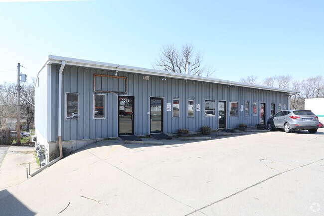
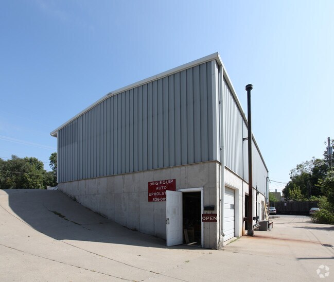
Property Record
701 E 23Rd St S, Independence, MO 64055

Property Detail
701 E 23Rd St S
Kansas City, MO-KS
FAIRWAY PARK LOTS 51 52 & 53 (EX N 24 MOL TAKEN FOR ROW)
26-540-02-10-00-0-00-000
Jackson
Storebuilding
Missouri
B and X Area of moderate flood hazard, usually the area between the limits of the 100-year and 500-year floods.
51
2024
0.28 AC
2025
East Jackson County
012300
Kansas City
6,400 SF
NEARBY LISTINGS FOR SALE OR LEASE
DEMOGRAPHICS near 701 E 23Rd St S
1 mile
3 mile
5 mile
2025 Total Population
9,320
78,016
144,683
2030 Population
9,419
78,303
145,394
Pop Growth 2025-2030
+ 1.06%
+ 0.37%
+ 0.49%
Average Age
41
41
41
2025 Total Households
3,847
32,794
59,856
HH Growth 2025-2030
+ 1.04%
+ 0.32%
+ 0.48%
Median Household Inc
$52,556
$58,118
$60,642
Avg Household Size
2.30
2.30
2.30
2025 Avg HH Vehicles
2.00
2.00
2.00
Median Home Value
$158,168
$171,271
$175,079
Median Year Built
1954
1964
1968
Nearby Places
Map Layers
Map Styles
 Street
 Aerial
Transit
 Traffic
 Biking
Places
Listings with unknown addresses are not visible on the map
- Restaurants
- Banks
- Shops
- Fitness
- Groceries
PUBLIC TRANSPORTATION
COMMUTER RAIL
Drive
Walk
Distance
4 min
2.2 mi
AIRPORT
Kansas City International
Drive
Walk
Distance
Kansas City International
42 min
31.5 mi
SALE & LEASE HISTORY
LISTING DATE
SALE/LEASE

Mar 22, 2021
For Sale
Mar 05, 2020
For Sale
Apr 18, 2018
For Lease
Nearby Properties
Address
Land Use
TOTAL SIZE
Lot Size
Zoning
Address
Land Use
TOTAL SIZE
Lot Size
Zoning
519,315 SF
28.47 AC
Address
Land Use
TOTAL SIZE
Lot Size
Zoning
250,196 SF
39.50 AC
Address
Land Use
TOTAL SIZE
Lot Size
Zoning
455,100 SF
42.02 AC
Address
Land Use
TOTAL SIZE
Lot Size
Zoning
123,305 SF
15.51 AC
Address
Land Use
TOTAL SIZE
Lot Size
Zoning
64,318 SF
32.40 AC
Address
Land Use
TOTAL SIZE
Lot Size
Zoning
74,801 SF
8.93 AC
Address
Land Use
TOTAL SIZE
Lot Size
Zoning
157,666 SF
18.54 AC
Address
Land Use
TOTAL SIZE
Lot Size
Zoning
139,713 SF
15.70 AC
Address
Land Use
TOTAL SIZE
Lot Size
Zoning
157,429 SF
36.60 AC
Address
Land Use
TOTAL SIZE
Lot Size
Zoning
111,445 SF
8 AC
Address
Land Use
TOTAL SIZE
Lot Size
Zoning
48,664 SF
8.44 AC
Address
Land Use
TOTAL SIZE
Lot Size
Zoning
71,339 SF
0.68 AC
Address
Land Use
TOTAL SIZE
Lot Size
Zoning
113,667 SF
6.31 AC
Address
Land Use
TOTAL SIZE
Lot Size
Zoning
190,810 SF
26.90 AC
Address
Land Use
TOTAL SIZE
Lot Size
Zoning
55,985 SF
20.93 AC
Address
Land Use
TOTAL SIZE
Lot Size
Zoning
23,925 SF
19.96 AC
Address
Land Use
TOTAL SIZE
Lot Size
Zoning
36,883 SF
14.60 AC
Address
Land Use
TOTAL SIZE
Lot Size
Zoning
45,832 SF
8.61 AC
Address
Land Use
TOTAL SIZE
Lot Size
Zoning
286,490 SF
37.30 AC
Address
Land Use
TOTAL SIZE
Lot Size
Zoning
66,168 SF
44.98 AC
Address
Land Use
TOTAL SIZE
Lot Size
Zoning
45,870 SF
2.01 AC
Address
Land Use
TOTAL SIZE
Lot Size
Zoning
30,630 SF
14.08 AC
Address
Land Use
TOTAL SIZE
Lot Size
Zoning
104,740 SF
7.25 AC
Address
Land Use
TOTAL SIZE
Lot Size
Zoning
114,248 SF
5.02 AC
Address
Land Use
TOTAL SIZE
Lot Size
Zoning
111,617 SF
9.12 AC
Address
Land Use
TOTAL SIZE
Lot Size
Zoning
111,120 SF
12.61 AC
Address
Land Use
TOTAL SIZE
Lot Size
Zoning
127,582 SF
11.22 AC
Address
Land Use
TOTAL SIZE
Lot Size
Zoning
46,125 SF
4.68 AC
Address
Land Use
TOTAL SIZE
Lot Size
Zoning
81,990 SF
3.47 AC
Address
Land Use
TOTAL SIZE
Lot Size
Zoning
153,774 SF
The World's #1 Commercial Real Estate Marketplace
Connect with us
© 2026 CoStar Group
The information above has been obtained from sources believed reliable. While we do not doubt its accuracy we have not verified it and make no guarantee, warranty or representation about it. It is your responsibility to independently confirm its accuracy and completeness. Any projections, opinions, assumptions, or estimates used are for example only and do not represent the current or future performance of the property. The value of this transaction to you depends on tax and other factors which should be evaluated by your tax, financial, and legal advisors. You and your advisors should conduct a careful, independent investigation of the property to determine to your satisfaction the suitability of the property for your needs.