Property Record
701 E 7Th Ave, Columbus, OH 43219
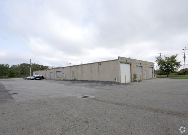

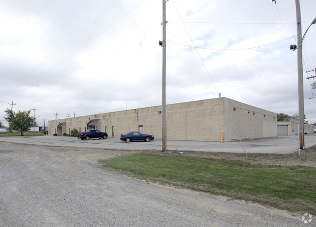
Property Detail
701 E 7Th Ave
010-212012
JAMES PIKE R17 T1 S4 1.411 ACRES
Warehouse
FRANKLIN
B and X Area of moderate flood hazard, usually the area between the limits of the 100-year and 500-year floods.
Ohio
2024
1.41 AC
2025
Airport
007550
Columbus
19,920 SF
Columbus, OH
NEARBY LISTINGS FOR SALE OR LEASE
DEMOGRAPHICS near 701 E 7Th Ave
1 mile
3 mile
5 mile
2025 Total Population
4,177
96,394
292,744
2030 Population
4,367
99,988
304,522
Pop Growth 2025-2030
+ 4.55%
+ 3.73%
+ 4.02%
Average Age
36
38
37
2025 Total Households
1,861
39,209
121,694
HH Growth 2025-2030
+ 4.41%
+ 3.96%
+ 4.27%
Median Household Inc
$32,563
$54,490
$54,251
Avg Household Size
2.20
2.30
2.30
2025 Avg HH Vehicles
1.00
2.00
2.00
Median Home Value
$110,417
$247,820
$249,872
Median Year Built
1962
1965
1967
Nearby Places
Map Layers
Map Styles
 Street
 Aerial
Transit
 Traffic
 Biking
Places
Listings with unknown addresses are not visible on the map
- Restaurants
- Banks
- Shops
- Fitness
- Groceries
PUBLIC TRANSPORTATION
AIRPORT
John Glenn Columbus International
Drive
Walk
Distance
John Glenn Columbus International
6 min
2.6 mi
Rickenbacker International
Drive
Walk
Distance
Rickenbacker International
27 min
14.1 mi
SALE & LEASE HISTORY
LISTING DATE
SALE/LEASE

Feb 27, 2018
For Lease
Nearby Properties
Address
Land Use
TOTAL SIZE
Lot Size
Zoning
Address
Land Use
TOTAL SIZE
Lot Size
Zoning
316,415 SF
415.78 AC
Address
Land Use
TOTAL SIZE
Lot Size
Zoning
1,256,678 SF
1,292.62 AC
Address
Land Use
TOTAL SIZE
Lot Size
Zoning
Address
Land Use
TOTAL SIZE
Lot Size
Zoning
770,975 SF
64.63 AC
Address
Land Use
TOTAL SIZE
Lot Size
Zoning
180,383 SF
15.54 AC
Address
Land Use
TOTAL SIZE
Lot Size
Zoning
184,777 SF
3.67 AC
Address
Land Use
TOTAL SIZE
Lot Size
Zoning
573,031 SF
5.88 AC
Address
Land Use
TOTAL SIZE
Lot Size
Zoning
122,526 SF
27 AC
Address
Land Use
TOTAL SIZE
Lot Size
Zoning
299,220 SF
29.68 AC
Address
Land Use
TOTAL SIZE
Lot Size
Zoning
183,352 SF
55.41 AC
Address
Land Use
TOTAL SIZE
Lot Size
Zoning
282,035 SF
29.29 AC
Address
Land Use
TOTAL SIZE
Lot Size
Zoning
274,272 SF
6.45 AC
Address
Land Use
TOTAL SIZE
Lot Size
Zoning
332,616 SF
26.90 AC
Address
Land Use
TOTAL SIZE
Lot Size
Zoning
209,542 SF
27.50 AC
Address
Land Use
TOTAL SIZE
Lot Size
Zoning
398,836 SF
14.37 AC
Address
Land Use
TOTAL SIZE
Lot Size
Zoning
42,596 SF
37.05 AC
Address
Land Use
TOTAL SIZE
Lot Size
Zoning
67,166 SF
11.03 AC
Address
Land Use
TOTAL SIZE
Lot Size
Zoning
166,628 SF
9.98 AC
Address
Land Use
TOTAL SIZE
Lot Size
Zoning
706,471 SF
41.34 AC
Address
Land Use
TOTAL SIZE
Lot Size
Zoning
217,088 SF
10.67 AC
Address
Land Use
TOTAL SIZE
Lot Size
Zoning
205,370 SF
19.82 AC
Address
Land Use
TOTAL SIZE
Lot Size
Zoning
125,035 SF
9.12 AC
Address
Land Use
TOTAL SIZE
Lot Size
Zoning
1,264,151 SF
58.42 AC
Address
Land Use
TOTAL SIZE
Lot Size
Zoning
125,219 SF
3.49 AC
Address
Land Use
TOTAL SIZE
Lot Size
Zoning
170,209 SF
15.03 AC
Address
Land Use
TOTAL SIZE
Lot Size
Zoning
142,542 SF
6.55 AC
Address
Land Use
TOTAL SIZE
Lot Size
Zoning
142,542 SF
3.95 AC
Address
Land Use
TOTAL SIZE
Lot Size
Zoning
187,858 SF
19.50 AC
Address
Land Use
TOTAL SIZE
Lot Size
Zoning
22,323 SF
0.12 AC
Address
Land Use
TOTAL SIZE
Lot Size
Zoning
145,592 SF
4.48 AC
The World's #1 Commercial Real Estate Marketplace
Connect with us
© 2026 CoStar Group
The information above has been obtained from sources believed reliable. While we do not doubt its accuracy we have not verified it and make no guarantee, warranty or representation about it. It is your responsibility to independently confirm its accuracy and completeness. Any projections, opinions, assumptions, or estimates used are for example only and do not represent the current or future performance of the property. The value of this transaction to you depends on tax and other factors which should be evaluated by your tax, financial, and legal advisors. You and your advisors should conduct a careful, independent investigation of the property to determine to your satisfaction the suitability of the property for your needs.