Property Record
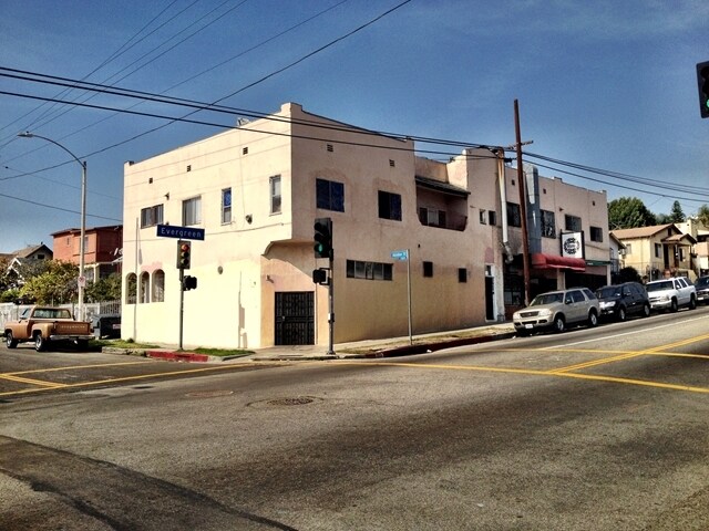
701 N Evergreen Ave, Los Angeles, CA 90033


Current Lease Availabilities
NEARBY LISTINGS FOR SALE OR LEASE
Property Detail
701 N Evergreen Ave
Los Angeles-Long Beach-Glendale, CA
Forest Heights Tract
5178-009-009
FOREST HEIGHTS TRACT SW 94 FT OF SE 5 FT OF LOT 9 AND SW 94 FT OF LOT 10 BLK E
Retailwithmorethanonenonretailuse
Los Angeles
X
California
06037C1637F
9,10
2024
0.11 AC
2025
Boyle Heights
203710
Los Angeles
7,312 SF
DEMOGRAPHICS near 701 N Evergreen Ave
1 Mile
3 Mile
5 Mile
2024 Total Population
56,435
275,009
843,710
2029 Population
54,272
264,493
810,794
Pop Growth 2024-2029
(3.83%)
(3.82%)
(3.90%)
Average Age
36
38
38
2024 Total Households
15,336
83,247
278,893
HH Growth 2024-2029
(4.13%)
(3.93%)
(3.76%)
Median Household Inc
$56,470
$54,497
$59,071
Avg Household Size
3.50
3.00
2.80
2024 Avg HH Vehicles
2.00
2.00
2.00
Median Home Value
$637,175
$692,168
$741,220
Median Year Built
1948
1953
1957
Nearby Places
Map Layers
Map Styles
 Street
 Aerial
- Restaurants
- Banks
- Shops
- Fitness
- Groceries
PUBLIC TRANSPORTATION
TRANSIT/SUBWAY
Soto (Gold Line - Los Angeles County Metropolitan Transportation Authority (Metro))
DRIVE
WALK
Distance
Soto (Gold Line - Los Angeles County Metropolitan Transportation Authority (Metro))
2 min
18 min
0.9 mi
COMMUTER RAIL
Union Station (91 Line - Southern California Regional Rail Authority (Metrolink), Antelope Valley Line - Southern California Regional Rail Authority (Metrolink), Orange County Line - Southern California Regional Rail Authority (Metrolink), Riverside Line - Southern California Regional Rail Authority (Metrolink), San Bernardino Line - Southern California Regional Rail Authority (Metrolink), Ventura County Line - Southern California Regional Rail Authority (Metrolink))
DRIVE
WALK
Distance
Union Station (91 Line - Southern California Regional Rail Authority (Metrolink), Antelope Valley Line - Southern California Regional Rail Authority (Metrolink), Orange County Line - Southern California Regional Rail Authority (Metrolink), Riverside Line - Southern California Regional Rail Authority (Metrolink), San Bernardino Line - Southern California Regional Rail Authority (Metrolink), Ventura County Line - Southern California Regional Rail Authority (Metrolink))
9 min
2.7 mi
DRIVE
WALK
Distance
6 min
2.8 mi
AIRPORT
Bob Hope
DRIVE
WALK
Distance
Bob Hope
25 min
17.8 mi
Los Angeles International
DRIVE
WALK
Distance
Los Angeles International
31 min
19.0 mi
Long Beach (Daugherty Field)
DRIVE
WALK
Distance
Long Beach (Daugherty Field)
30 min
19.9 mi
Freight Ports
Port of Long Beach
DRIVE
WALK
Distance
Port of Long Beach
32 min
22.7 mi
Nearby Properties
Address
Land Use
TOTAL SIZE
Lot Size
Zoning
Address
Land Use
TOTAL SIZE
Lot Size
Zoning
2,697,158 SF
20.18 AC
LAM2
Address
Land Use
TOTAL SIZE
Lot Size
Zoning
465,722 SF
5.84 AC
LAC4
Address
Land Use
TOTAL SIZE
Lot Size
Zoning
635,233 SF
12.02 AC
LAR5
Address
Land Use
TOTAL SIZE
Lot Size
Zoning
513,825 SF
4.28 AC
LAC2
Address
Land Use
TOTAL SIZE
Lot Size
Zoning
444,139 SF
3.63 AC
LAM3
Address
Land Use
TOTAL SIZE
Lot Size
Zoning
534,225 SF
Address
Land Use
TOTAL SIZE
Lot Size
Zoning
479,272 SF
16.14 AC
LAM3
Address
Land Use
TOTAL SIZE
Lot Size
Zoning
1,088,170 SF
15.98 AC
LAM3
Address
Land Use
TOTAL SIZE
Lot Size
Zoning
535,949 SF
5.85 AC
LAM3
Address
Land Use
TOTAL SIZE
Lot Size
Zoning
1,059,650 SF
1.07 AC
LAC2
Address
Land Use
TOTAL SIZE
Lot Size
Zoning
327,061 SF
2.18 AC
LAM3
Address
Land Use
TOTAL SIZE
Lot Size
Zoning
322,080 SF
2.85 AC
LAC2
Address
Land Use
TOTAL SIZE
Lot Size
Zoning
175.69 AC
LAA1
Address
Land Use
TOTAL SIZE
Lot Size
Zoning
182,700 SF
8.29 AC
LAM3
Address
Land Use
TOTAL SIZE
Lot Size
Zoning
328,737 SF
7.92 AC
LAC2
Address
Land Use
TOTAL SIZE
Lot Size
Zoning
642,160 SF
8.26 AC
LAADP
Address
Land Use
TOTAL SIZE
Lot Size
Zoning
368,058 SF
2.65 AC
LAUC (CA)
Address
Land Use
TOTAL SIZE
Lot Size
Zoning
354,299 SF
2.18 AC
LAC2
Address
Land Use
TOTAL SIZE
Lot Size
Zoning
150,608 SF
0.88 AC
LAC2
Address
Land Use
TOTAL SIZE
Lot Size
Zoning
318,903 SF
1.10 AC
LAC4
Address
Land Use
TOTAL SIZE
Lot Size
Zoning
223,783 SF
0.94 AC
LAC2
Address
Land Use
TOTAL SIZE
Lot Size
Zoning
107,106 SF
0.46 AC
LAC4
Address
Land Use
TOTAL SIZE
Lot Size
Zoning
850,903 SF
4.52 AC
LAR5
Address
Land Use
TOTAL SIZE
Lot Size
Zoning
252,825 SF
1.74 AC
LAC2
Address
Land Use
TOTAL SIZE
Lot Size
Zoning
235,102 SF
1.71 AC
LAC2
Address
Land Use
TOTAL SIZE
Lot Size
Zoning
397,866 SF
3.51 AC
LAM3
Address
Land Use
TOTAL SIZE
Lot Size
Zoning
527,173 SF
12.36 AC
CMM2*
Address
Land Use
TOTAL SIZE
Lot Size
Zoning
276,452 SF
1.21 AC
LAM3
Address
Land Use
TOTAL SIZE
Lot Size
Zoning
209,559 SF
0.88 AC
LAR5
Address
Land Use
TOTAL SIZE
Lot Size
Zoning
225,923 SF
1.31 AC
LAR5
The World's #1 Commercial Real Estate Marketplace
Connect with us
© 2026 CoStar Group
The information above has been obtained from sources believed reliable. While we do not doubt its accuracy we have not verified it and make no guarantee, warranty or representation about it. It is your responsibility to independently confirm its accuracy and completeness. Any projections, opinions, assumptions, or estimates used are for example only and do not represent the current or future performance of the property. The value of this transaction to you depends on tax and other factors which should be evaluated by your tax, financial, and legal advisors. You and your advisors should conduct a careful, independent investigation of the property to determine to your satisfaction the suitability of the property for your needs.