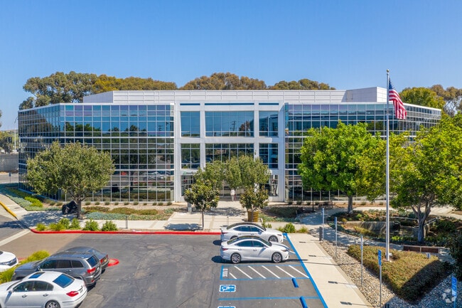
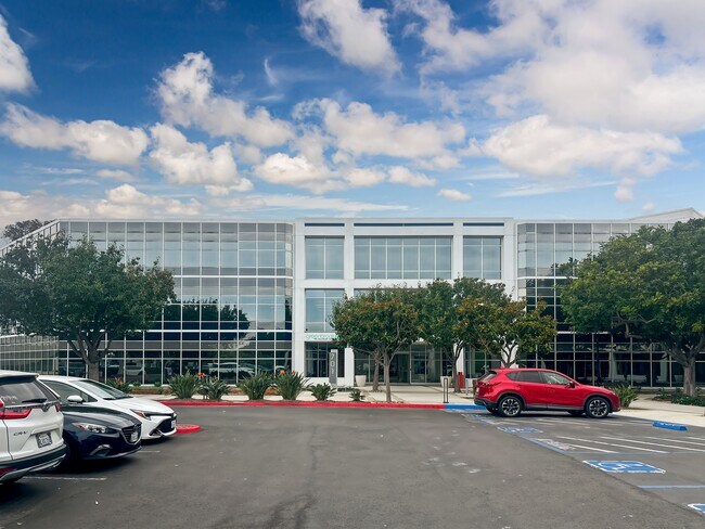
Property Record
701 Palomar Airport Rd, Carlsbad, CA 92011


Current Lease Availabilities
NEARBY LISTINGS FOR SALE OR LEASE
Property Detail
701 Palomar Airport Rd
San Diego-Carlsbad, CA
City Of Carlsbad
210-100-17
PAR 1 (EX ST) TR PM15386
Storesoffices
San Diego
X
California
06073C1027H
4a,5
2024
2.32 AC
2025
Carlsbad
017813
San Diego
50,700 SF
DEMOGRAPHICS near 701 Palomar Airport Rd
1 Mile
3 Mile
5 Mile
2024 Total Population
3,472
47,297
136,192
2029 Population
3,481
47,204
135,398
Pop Growth 2024-2029
+ 0.26%
(0.20%)
(0.58%)
Average Age
45
43
43
2024 Total Households
1,493
19,222
55,263
HH Growth 2024-2029
+ 0.13%
(0.25%)
(0.69%)
Median Household Inc
$117,642
$117,876
$114,019
Avg Household Size
2.30
2.40
2.40
2024 Avg HH Vehicles
2.00
2.00
2.00
Median Home Value
$970,224
$1,021,667
$961,752
Median Year Built
1978
1987
1984
Nearby Places
Map Layers
Map Styles
 Street
 Aerial
- Restaurants
- Banks
- Shops
- Fitness
- Groceries
PUBLIC TRANSPORTATION
COMMUTER RAIL
Carlsbad Poinsettia (Coaster - San Diego North County Transit District (Coaster/Sprinter/Breeze))
DRIVE
WALK
Distance
Carlsbad Poinsettia (Coaster - San Diego North County Transit District (Coaster/Sprinter/Breeze))
3 min
19 min
1.0 mi
Carlsbad Village (Coaster - San Diego North County Transit District (Coaster/Sprinter/Breeze))
DRIVE
WALK
Distance
Carlsbad Village (Coaster - San Diego North County Transit District (Coaster/Sprinter/Breeze))
9 min
4.4 mi
AIRPORT
San Diego International
DRIVE
WALK
Distance
San Diego International
38 min
29.8 mi
Freight Ports
Port of San Diego
DRIVE
WALK
Distance
Port of San Diego
43 min
34.1 mi
Nearby Properties
Address
Land Use
TOTAL SIZE
Lot Size
Zoning
Address
Land Use
TOTAL SIZE
Lot Size
Zoning
59,518 SF
5.70 AC
P-U
Address
Land Use
TOTAL SIZE
Lot Size
Zoning
132.11 AC
C-T-Q
Address
Land Use
TOTAL SIZE
Lot Size
Zoning
26.65 AC
C-2-Q
Address
Land Use
TOTAL SIZE
Lot Size
Zoning
12.62 AC
P-C
Address
Land Use
TOTAL SIZE
Lot Size
Zoning
4.32 AC
N-LVSC
Address
Land Use
TOTAL SIZE
Lot Size
Zoning
12.71 AC
P-M
Address
Land Use
TOTAL SIZE
Lot Size
Zoning
28.15 AC
C-M
Address
Land Use
TOTAL SIZE
Lot Size
Zoning
16.79 AC
R-3-Q
Address
Land Use
TOTAL SIZE
Lot Size
Zoning
10.96 AC
C-M
Address
Land Use
TOTAL SIZE
Lot Size
Zoning
13.86 AC
C-M
Address
Land Use
TOTAL SIZE
Lot Size
Zoning
13.07 AC
P-M
Address
Land Use
TOTAL SIZE
Lot Size
Zoning
9.65 AC
P-C
Address
Land Use
TOTAL SIZE
Lot Size
Zoning
18.34 AC
P-C
Address
Land Use
TOTAL SIZE
Lot Size
Zoning
9.69 AC
C-T-Q
Address
Land Use
TOTAL SIZE
Lot Size
Zoning
5.45 AC
C-T
Address
Land Use
TOTAL SIZE
Lot Size
Zoning
20.86 AC
P-M-Q
Address
Land Use
TOTAL SIZE
Lot Size
Zoning
60.48 AC
OS
Address
Land Use
TOTAL SIZE
Lot Size
Zoning
3.17 AC
C-T
Address
Land Use
TOTAL SIZE
Lot Size
Zoning
7.42 AC
P-M
Address
Land Use
TOTAL SIZE
Lot Size
Zoning
7.38 AC
P-M-Q
Address
Land Use
TOTAL SIZE
Lot Size
Zoning
8.64 AC
R-3-Q
Address
Land Use
TOTAL SIZE
Lot Size
Zoning
95,418 SF
6.51 AC
P-C
Address
Land Use
TOTAL SIZE
Lot Size
Zoning
55,656 SF
13.04 AC
R-1-Q
Address
Land Use
TOTAL SIZE
Lot Size
Zoning
9.76 AC
M
Address
Land Use
TOTAL SIZE
Lot Size
Zoning
57,905 SF
2.16 AC
R-3
Address
Land Use
TOTAL SIZE
Lot Size
Zoning
6.90 AC
C-M
Address
Land Use
TOTAL SIZE
Lot Size
Zoning
4.88 AC
P-C
Address
Land Use
TOTAL SIZE
Lot Size
Zoning
2.64 AC
P-M
Address
Land Use
TOTAL SIZE
Lot Size
Zoning
88,188 SF
1.95 AC
N-R3
Address
Land Use
TOTAL SIZE
Lot Size
Zoning
65,359 SF
3.71 AC
C-2-Q
The World's #1 Commercial Real Estate Marketplace
Connect with us
© 2025 CoStar Group
The information above has been obtained from sources believed reliable. While we do not doubt its accuracy we have not verified it and make no guarantee, warranty or representation about it. It is your responsibility to independently confirm its accuracy and completeness. Any projections, opinions, assumptions, or estimates used are for example only and do not represent the current or future performance of the property. The value of this transaction to you depends on tax and other factors which should be evaluated by your tax, financial, and legal advisors. You and your advisors should conduct a careful, independent investigation of the property to determine to your satisfaction the suitability of the property for your needs.