Property Record
701 Yunker St, Mc Kees Rocks, PA 15136


Property Detail
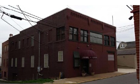
701 Yunker St
Pittsburgh, PA
P STEINMILLER PLAN 12-13 LOT 58XAVG102X45 RR IN ALL YUNKER ST 2 STY BRK APT BLDG 701-703
0043-J-00144-0000-00
Allegheny
Storebuilding
Pennsylvania
B and X Area of moderate flood hazard, usually the area between the limits of the 100-year and 500-year floods.
144
2026
0.12 AC
2026
West Pittsburgh
464400
Pittsburgh
NEARBY LISTINGS FOR SALE OR LEASE
DEMOGRAPHICS near 701 Yunker St
1 mile
3 mile
5 mile
2025 Total Population
15,724
92,879
227,122
2030 Population
15,716
92,174
225,476
Pop Growth 2025-2030
(0.05%)
(0.76%)
(0.72%)
Average Age
39
41
41
2025 Total Households
6,801
42,949
105,217
HH Growth 2025-2030
(0.10%)
(0.85%)
(0.75%)
Median Household Inc
$47,006
$63,268
$70,957
Avg Household Size
2.20
2.10
2.00
2025 Avg HH Vehicles
1.00
1.00
1.00
Median Home Value
$96,483
$177,942
$207,286
Median Year Built
1948
1949
1953
Nearby Places
Map Layers
Map Styles
 Street
 Aerial
Layers
 Traffic
 Biking
Places
Listings with unknown addresses are not visible on the map
- Restaurants
- Banks
- Shops
- Fitness
- Groceries
PUBLIC TRANSPORTATION
COMMUTER RAIL
Drive
Walk
Distance
11 min
5.0 mi
AIRPORT
Pittsburgh International
Drive
Walk
Distance
Pittsburgh International
29 min
13.1 mi
Arnold Palmer Regional
Drive
Walk
Distance
Arnold Palmer Regional
73 min
47.2 mi
SALE & LEASE HISTORY
LISTING DATE
SALE/LEASE

Sep 23, 2016
For Sale
Nearby Properties
Address
Land Use
TOTAL SIZE
Lot Size
Zoning
Address
Land Use
TOTAL SIZE
Lot Size
Zoning
10.41 AC
Address
Land Use
TOTAL SIZE
Lot Size
Zoning
13.75 AC
Address
Land Use
TOTAL SIZE
Lot Size
Zoning
26.68 AC
Address
Land Use
TOTAL SIZE
Lot Size
Zoning
Address
Land Use
TOTAL SIZE
Lot Size
Zoning
21.20 AC
Address
Land Use
TOTAL SIZE
Lot Size
Zoning
105.09 AC
Address
Land Use
TOTAL SIZE
Lot Size
Zoning
6.55 AC
Address
Land Use
TOTAL SIZE
Lot Size
Zoning
1.66 AC
Address
Land Use
TOTAL SIZE
Lot Size
Zoning
6.40 AC
Address
Land Use
TOTAL SIZE
Lot Size
Zoning
1.22 AC
Address
Land Use
TOTAL SIZE
Lot Size
Zoning
16.54 AC
Address
Land Use
TOTAL SIZE
Lot Size
Zoning
1,556 SF
36.30 AC
Address
Land Use
TOTAL SIZE
Lot Size
Zoning
25.70 AC
Address
Land Use
TOTAL SIZE
Lot Size
Zoning
Address
Land Use
TOTAL SIZE
Lot Size
Zoning
Address
Land Use
TOTAL SIZE
Lot Size
Zoning
72.69 AC
Address
Land Use
TOTAL SIZE
Lot Size
Zoning
25.09 AC
Address
Land Use
TOTAL SIZE
Lot Size
Zoning
24.04 AC
Address
Land Use
TOTAL SIZE
Lot Size
Zoning
39.74 AC
Address
Land Use
TOTAL SIZE
Lot Size
Zoning
Address
Land Use
TOTAL SIZE
Lot Size
Zoning
3.83 AC
Address
Land Use
TOTAL SIZE
Lot Size
Zoning
13.86 AC
Address
Land Use
TOTAL SIZE
Lot Size
Zoning
Address
Land Use
TOTAL SIZE
Lot Size
Zoning
Address
Land Use
TOTAL SIZE
Lot Size
Zoning
11.93 AC
Address
Land Use
TOTAL SIZE
Lot Size
Zoning
2.51 AC
Address
Land Use
TOTAL SIZE
Lot Size
Zoning
9.18 AC
Address
Land Use
TOTAL SIZE
Lot Size
Zoning
6.15 AC
Address
Land Use
TOTAL SIZE
Lot Size
Zoning
21.49 AC
Address
Land Use
TOTAL SIZE
Lot Size
Zoning
The World's #1 Commercial Real Estate Marketplace
Connect with us
© 2026 CoStar Group
The information above has been obtained from sources believed reliable. While we do not doubt its accuracy we have not verified it and make no guarantee, warranty or representation about it. It is your responsibility to independently confirm its accuracy and completeness. Any projections, opinions, assumptions, or estimates used are for example only and do not represent the current or future performance of the property. The value of this transaction to you depends on tax and other factors which should be evaluated by your tax, financial, and legal advisors. You and your advisors should conduct a careful, independent investigation of the property to determine to your satisfaction the suitability of the property for your needs.