Property Record
704 N Fresno St, Fresno, CA 93701
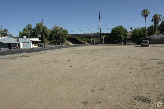
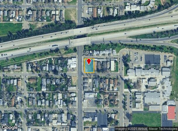
This Property Is For Sale
NEARBY LISTINGS FOR SALE OR LEASE
Property Detail
704 N Fresno St
Fresno, CA
Belmont Add
452-244-19
LOTS 1-4 IN BLK 14 BELMONT ADD
Commercialacreage
Fresno
X
California
06019C1570H
2
2025
0.34 AC
2025
Downtown Fresno
002400
Fresno
DEMOGRAPHICS near 704 N Fresno St
1 Mile
3 Mile
5 Mile
2024 Total Population
23,834
179,969
364,055
2029 Population
24,333
183,097
370,771
Pop Growth 2024-2029
+ 2.09%
+ 1.74%
+ 1.84%
Average Age
33
34
34
2024 Total Households
7,120
54,460
114,179
HH Growth 2024-2029
+ 2.09%
+ 1.77%
+ 1.89%
Median Household Inc
$31,728
$39,576
$44,954
Avg Household Size
3.20
3.10
3.00
2024 Avg HH Vehicles
1.00
2.00
2.00
Median Home Value
$167,324
$229,174
$248,484
Median Year Built
1961
1958
1967
Nearby Places
Map Layers
Map Styles
 Street
 Aerial
- Restaurants
- Banks
- Shops
- Fitness
- Groceries
PUBLIC TRANSPORTATION
COMMUTER RAIL
DRIVE
WALK
Distance
3 min
1.3 mi
AIRPORT
Fresno Yosemite International
DRIVE
WALK
Distance
Fresno Yosemite International
9 min
4.8 mi
Nearby Properties
Address
Land Use
TOTAL SIZE
Lot Size
Zoning
Address
Land Use
TOTAL SIZE
Lot Size
Zoning
0.01 AC
P
Address
Land Use
TOTAL SIZE
Lot Size
Zoning
534,993 SF
5.23 AC
CP
Address
Land Use
TOTAL SIZE
Lot Size
Zoning
288,597 SF
1.18 AC
C4
Address
Land Use
TOTAL SIZE
Lot Size
Zoning
147,101 SF
6.31 AC
SPLIT
Address
Land Use
TOTAL SIZE
Lot Size
Zoning
184,130 SF
1.87 AC
PI
Address
Land Use
TOTAL SIZE
Lot Size
Zoning
101,510 SF
3.37 AC
CM
Address
Land Use
TOTAL SIZE
Lot Size
Zoning
471,760 SF
1.98 AC
CP
Address
Land Use
TOTAL SIZE
Lot Size
Zoning
213,874 SF
4.17 AC
SPLIT
Address
Land Use
TOTAL SIZE
Lot Size
Zoning
206,766 SF
17.11 AC
R2
Address
Land Use
TOTAL SIZE
Lot Size
Zoning
79,518 SF
2.03 AC
R4
Address
Land Use
TOTAL SIZE
Lot Size
Zoning
480,570 SF
2.98 AC
P
Address
Land Use
TOTAL SIZE
Lot Size
Zoning
90,500 SF
1.29 AC
CM
Address
Land Use
TOTAL SIZE
Lot Size
Zoning
110,456 SF
6.56 AC
RMX
Address
Land Use
TOTAL SIZE
Lot Size
Zoning
314,915 SF
14.12 AC
M2
Address
Land Use
TOTAL SIZE
Lot Size
Zoning
55,200 SF
14.94 AC
M3
Address
Land Use
TOTAL SIZE
Lot Size
Zoning
96,012 SF
1.33 AC
C4
Address
Land Use
TOTAL SIZE
Lot Size
Zoning
669,447 SF
0.01 AC
C3
Address
Land Use
TOTAL SIZE
Lot Size
Zoning
82,096 SF
0.26 AC
C4
Address
Land Use
TOTAL SIZE
Lot Size
Zoning
96,012 SF
0.60 AC
C4
Address
Land Use
TOTAL SIZE
Lot Size
Zoning
203,687 SF
10.63 AC
R3
Address
Land Use
TOTAL SIZE
Lot Size
Zoning
121,250 SF
9.51 AC
R3
Address
Land Use
TOTAL SIZE
Lot Size
Zoning
141,577 SF
12.76 AC
IL
Address
Land Use
TOTAL SIZE
Lot Size
Zoning
89,097 SF
0.63 AC
CC
Address
Land Use
TOTAL SIZE
Lot Size
Zoning
92,096 SF
0.01 AC
C3
Address
Land Use
TOTAL SIZE
Lot Size
Zoning
91,517 SF
1.80 AC
SPLIT
Address
Land Use
TOTAL SIZE
Lot Size
Zoning
108,017 SF
2.91 AC
CM
Address
Land Use
TOTAL SIZE
Lot Size
Zoning
372,640 SF
4.35 AC
CP
Address
Land Use
TOTAL SIZE
Lot Size
Zoning
95,932 SF
10.98 AC
C3
Address
Land Use
TOTAL SIZE
Lot Size
Zoning
37,017 SF
1.19 AC
CM
Address
Land Use
TOTAL SIZE
Lot Size
Zoning
173,949 SF
11.53 AC
M2
The World's #1 Commercial Real Estate Marketplace
Connect with us
© 2026 CoStar Group
The information above has been obtained from sources believed reliable. While we do not doubt its accuracy we have not verified it and make no guarantee, warranty or representation about it. It is your responsibility to independently confirm its accuracy and completeness. Any projections, opinions, assumptions, or estimates used are for example only and do not represent the current or future performance of the property. The value of this transaction to you depends on tax and other factors which should be evaluated by your tax, financial, and legal advisors. You and your advisors should conduct a careful, independent investigation of the property to determine to your satisfaction the suitability of the property for your needs.