Property Record
705 3Rd St N, Jacksonville Beach, FL 32250


Save to a Folder
{{folder.Name}}
{{folder.ListingIds.length}} Properties
{{folder.ListingIds.length}} Property
Create a New Folder
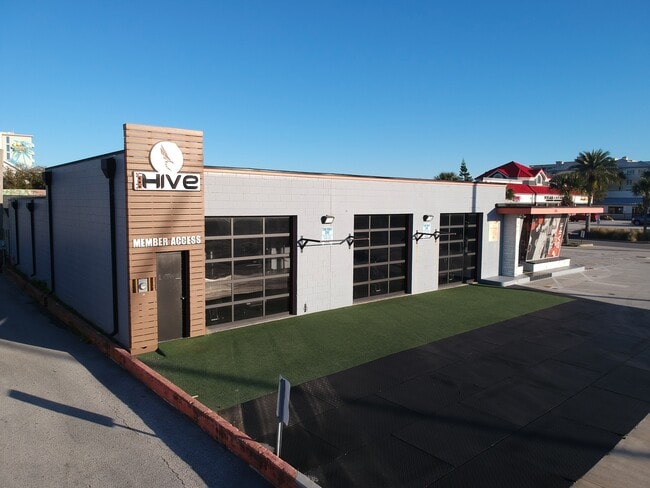
Property Detail
705 3Rd St N
174270-0000
5-66 33-2S-29E PABLO BEACH NORTH R/P LOTS 11,12 BLK 73
Bowlingalley
Duval
JC-1
Florida
AE The base floodplain where base flood elevations are provided. AE Zones are now used on new format FIRMs instead of A1-A30 Zones.
11,12
2025
0.29 AC
2026
Beaches
014104
Jacksonville (Florida)
4,935 SF
Jacksonville, FL
NEARBY LISTINGS FOR SALE OR LEASE
DEMOGRAPHICS near 705 3Rd St N
1 mile
3 mile
5 mile
2025 Total Population
11,048
46,306
113,177
2030 Population
11,827
49,081
121,099
Pop Growth 2025-2030
+ 7.05%
+ 5.99%
+ 7.00%
Average Age
43
43
42
2025 Total Households
5,554
21,506
50,360
HH Growth 2025-2030
+ 7.53%
+ 6.44%
+ 7.34%
Median Household Inc
$119,709
$113,016
$101,474
Avg Household Size
2.00
2.10
2.20
2025 Avg HH Vehicles
2.00
2.00
2.00
Median Home Value
$622,365
$622,845
$541,278
Median Year Built
1980
1984
1991
Nearby Places
Map Layers
Map Styles
 Street
 Aerial
Layers
 Traffic
 Biking
Places
Listings with unknown addresses are not visible on the map
- Restaurants
- Banks
- Shops
- Fitness
- Groceries
PUBLIC TRANSPORTATION
AIRPORT
Jacksonville International
Drive
Walk
Distance
Jacksonville International
45 min
28.7 mi
Freight Ports
Jacksonville Port
Drive
Walk
Distance
Jacksonville Port
35 min
19.3 mi
SALE & LEASE HISTORY
LISTING DATE
SALE/LEASE

May 13, 2019
For Lease
Jan 06, 2026
For Sale
Nearby Properties
Address
Land Use
TOTAL SIZE
Lot Size
Zoning
Address
Land Use
TOTAL SIZE
Lot Size
Zoning
231,215 SF
22.79 AC
JPUD
Address
Land Use
TOTAL SIZE
Lot Size
Zoning
243,583 SF
23 AC
PUD
Address
Land Use
TOTAL SIZE
Lot Size
Zoning
235,939 SF
11.25 AC
JRM-1
Address
Land Use
TOTAL SIZE
Lot Size
Zoning
298,551 SF
29.03 AC
JPUD
Address
Land Use
TOTAL SIZE
Lot Size
Zoning
115,119 SF
1.14 AC
JRD
Address
Land Use
TOTAL SIZE
Lot Size
Zoning
214,856 SF
15.07 AC
JPUD
Address
Land Use
TOTAL SIZE
Lot Size
Zoning
50,124 SF
2.53 AC
JRM-2
Address
Land Use
TOTAL SIZE
Lot Size
Zoning
90,729 SF
0.99 AC
JRD
Address
Land Use
TOTAL SIZE
Lot Size
Zoning
65,384 SF
2.33 AC
ACG
Address
Land Use
TOTAL SIZE
Lot Size
Zoning
244,454 SF
14.76 AC
NR-5
Address
Land Use
TOTAL SIZE
Lot Size
Zoning
265,048 SF
16.20 AC
RMD-D
Address
Land Use
TOTAL SIZE
Lot Size
Zoning
44,526 SF
1.98 AC
JRM-2
Address
Land Use
TOTAL SIZE
Lot Size
Zoning
215,372 SF
19.20 AC
RG1
Address
Land Use
TOTAL SIZE
Lot Size
Zoning
166,277 SF
12.41 AC
JC-1
Address
Land Use
TOTAL SIZE
Lot Size
Zoning
203,317 SF
11.96 AC
RMD-D
Address
Land Use
TOTAL SIZE
Lot Size
Zoning
219,659 SF
21.37 AC
NR-1
Address
Land Use
TOTAL SIZE
Lot Size
Zoning
183,674 SF
22.19 AC
PUD
Address
Land Use
TOTAL SIZE
Lot Size
Zoning
206,190 SF
12.10 AC
RMD-D
Address
Land Use
TOTAL SIZE
Lot Size
Zoning
120,233 SF
14.08 AC
ACG
Address
Land Use
TOTAL SIZE
Lot Size
Zoning
26,510 SF
1.36 AC
JCBD
Address
Land Use
TOTAL SIZE
Lot Size
Zoning
122,836 SF
26.31 AC
JPUD
Address
Land Use
TOTAL SIZE
Lot Size
Zoning
74,004 SF
26.19 AC
JI-1
Address
Land Use
TOTAL SIZE
Lot Size
Zoning
136,558 SF
1.89 AC
JC-2
Address
Land Use
TOTAL SIZE
Lot Size
Zoning
68,760 SF
5.73 AC
JPUD
Address
Land Use
TOTAL SIZE
Lot Size
Zoning
106,594 SF
12.06 AC
JPUD
Address
Land Use
TOTAL SIZE
Lot Size
Zoning
104,220 SF
7.80 AC
JI-1
Address
Land Use
TOTAL SIZE
Lot Size
Zoning
17.79 AC
JRS-1
Address
Land Use
TOTAL SIZE
Lot Size
Zoning
128,543 SF
131 AC
PUD
Address
Land Use
TOTAL SIZE
Lot Size
Zoning
100,039 SF
6.30 AC
ARG-M
Address
Land Use
TOTAL SIZE
Lot Size
Zoning
149,477 SF
9.08 AC
CCG-1
The World's #1 Commercial Real Estate Marketplace
Connect with us
© 2026 CoStar Group
The information above has been obtained from sources believed reliable. While we do not doubt its accuracy we have not verified it and make no guarantee, warranty or representation about it. It is your responsibility to independently confirm its accuracy and completeness. Any projections, opinions, assumptions, or estimates used are for example only and do not represent the current or future performance of the property. The value of this transaction to you depends on tax and other factors which should be evaluated by your tax, financial, and legal advisors. You and your advisors should conduct a careful, independent investigation of the property to determine to your satisfaction the suitability of the property for your needs.