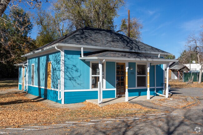
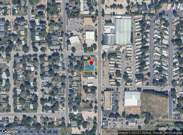
Property Record
705 S Public Rd, Lafayette, CO 80026
Property Detail
705 S Public Rd
Boulder, CO
Industrial City 2 - La
1575034-19-006
ALL LOTS 2 & 3 BLK 3 INDUSTRIAL CITY 2 2 IMPS
Commercialnec
Boulder
X
Colorado
08013C0602K
2
2024
0.30 AC
2025
Boulder
012905
Denver
1,296 SF
NEARBY LISTINGS FOR SALE OR LEASE
DEMOGRAPHICS near 705 S Public Rd
1 mile
3 mile
5 mile
2024 Total Population
15,054
52,172
134,945
2029 Population
15,024
52,495
141,929
Pop Growth 2024-2029
(0.20%)
+ 0.62%
+ 5.18%
Average Age
39
41
40
2024 Total Households
6,005
20,692
51,416
HH Growth 2024-2029
(0.33%)
+ 0.51%
+ 4.90%
Median Household Inc
$80,233
$110,601
$123,984
Avg Household Size
2.40
2.50
2.60
2024 Avg HH Vehicles
2.00
2.00
2.00
Median Home Value
$460,344
$689,252
$691,927
Median Year Built
1985
1995
1997
Nearby Places
Map Layers
Map Styles
 Street
 Aerial
Transit
 Traffic
 Biking
Places
Listings with unknown addresses are not visible on the map
- Restaurants
- Banks
- Shops
- Fitness
- Groceries
PUBLIC TRANSPORTATION
AIRPORT
Denver International
Drive
Walk
Distance
Denver International
40 min
33.0 mi
SALE & LEASE HISTORY
LISTING DATE
SALE/LEASE

Jun 15, 2023
For Sale
Jan 19, 2022
For Sale
Nearby Properties
Address
Land Use
TOTAL SIZE
Lot Size
Zoning
Address
Land Use
TOTAL SIZE
Lot Size
Zoning
420,330 SF
41.96 AC
A
Address
Land Use
TOTAL SIZE
Lot Size
Zoning
62.60 AC
Address
Land Use
TOTAL SIZE
Lot Size
Zoning
279.72 AC
A
Address
Land Use
TOTAL SIZE
Lot Size
Zoning
188,092 SF
2.01 AC
Address
Land Use
TOTAL SIZE
Lot Size
Zoning
57.98 AC
A
Address
Land Use
TOTAL SIZE
Lot Size
Zoning
120,510 SF
11.02 AC
Address
Land Use
TOTAL SIZE
Lot Size
Zoning
153,430 SF
12.16 AC
Address
Land Use
TOTAL SIZE
Lot Size
Zoning
137,435 SF
9.49 AC
Address
Land Use
TOTAL SIZE
Lot Size
Zoning
214,678 SF
10.46 AC
Address
Land Use
TOTAL SIZE
Lot Size
Zoning
113,473 SF
8.59 AC
Address
Land Use
TOTAL SIZE
Lot Size
Zoning
165,172 SF
11.12 AC
Address
Land Use
TOTAL SIZE
Lot Size
Zoning
116.21 AC
A
Address
Land Use
TOTAL SIZE
Lot Size
Zoning
164,842 SF
10.97 AC
Address
Land Use
TOTAL SIZE
Lot Size
Zoning
109,056 SF
7.76 AC
Address
Land Use
TOTAL SIZE
Lot Size
Zoning
76,658 SF
6.40 AC
Address
Land Use
TOTAL SIZE
Lot Size
Zoning
67,551 SF
4.27 AC
Address
Land Use
TOTAL SIZE
Lot Size
Zoning
130,348 SF
8.88 AC
Address
Land Use
TOTAL SIZE
Lot Size
Zoning
91,570 SF
6.09 AC
Address
Land Use
TOTAL SIZE
Lot Size
Zoning
136,448 SF
10.86 AC
Address
Land Use
TOTAL SIZE
Lot Size
Zoning
247,609 SF
14.53 AC
Address
Land Use
TOTAL SIZE
Lot Size
Zoning
132.98 AC
Address
Land Use
TOTAL SIZE
Lot Size
Zoning
109,547 SF
7.91 AC
Address
Land Use
TOTAL SIZE
Lot Size
Zoning
273,678 SF
10.79 AC
Address
Land Use
TOTAL SIZE
Lot Size
Zoning
76.96 AC
A
Address
Land Use
TOTAL SIZE
Lot Size
Zoning
83,615 SF
6.81 AC
Address
Land Use
TOTAL SIZE
Lot Size
Zoning
217,874 SF
10.49 AC
Address
Land Use
TOTAL SIZE
Lot Size
Zoning
97,831 SF
8.37 AC
Address
Land Use
TOTAL SIZE
Lot Size
Zoning
200,885 SF
17.84 AC
Address
Land Use
TOTAL SIZE
Lot Size
Zoning
64,231 SF
5.91 AC
Address
Land Use
TOTAL SIZE
Lot Size
Zoning
106,869 SF
7.46 AC
The World's #1 Commercial Real Estate Marketplace
Connect with us
© 2026 CoStar Group
The information above has been obtained from sources believed reliable. While we do not doubt its accuracy we have not verified it and make no guarantee, warranty or representation about it. It is your responsibility to independently confirm its accuracy and completeness. Any projections, opinions, assumptions, or estimates used are for example only and do not represent the current or future performance of the property. The value of this transaction to you depends on tax and other factors which should be evaluated by your tax, financial, and legal advisors. You and your advisors should conduct a careful, independent investigation of the property to determine to your satisfaction the suitability of the property for your needs.