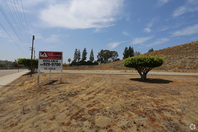
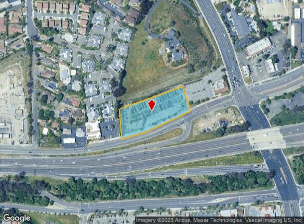
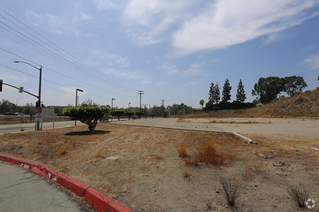
Property Record
707 W Vista Way, Vista, CA 92083
Current Lease Availabilities
NEARBY LISTINGS FOR SALE OR LEASE
Property Detail
707 W Vista Way
164-121-28
PAR B PAR B PER DOC18-0081406 IN TR PM06917
Commercialacreage
San Diego
X
California
06073C0759G
2.04 AC
2024
Vista
2025
San Diego
019406
San Diego-Carlsbad, CA
DEMOGRAPHICS near 707 W Vista Way
1 Mile
3 Mile
5 Mile
2024 Total Population
21,532
143,928
273,275
2029 Population
21,318
142,743
270,769
Pop Growth 2024-2029
(0.99%)
(0.82%)
(0.92%)
Average Age
37
39
40
2024 Total Households
6,852
47,757
93,252
HH Growth 2024-2029
(1.26%)
(1.05%)
(1.10%)
Median Household Inc
$80,234
$88,331
$90,659
Avg Household Size
2.90
2.90
2.80
2024 Avg HH Vehicles
2.00
2.00
2.00
Median Home Value
$567,404
$680,344
$698,672
Median Year Built
1981
1983
1984
Nearby Places
Map Layers
Map Styles
 Street
 Aerial
- Restaurants
- Banks
- Shops
- Fitness
- Groceries
PUBLIC TRANSPORTATION
TRANSIT/SUBWAY
Vista Transit Center (Sprinter - San Diego North County Transit District (Coaster/Sprinter/Breeze))
DRIVE
WALK
Distance
Vista Transit Center (Sprinter - San Diego North County Transit District (Coaster/Sprinter/Breeze))
2 min
20 min
1.1 mi
COMMUTER RAIL
Carlsbad Village (Coaster - San Diego North County Transit District (Coaster/Sprinter/Breeze))
DRIVE
WALK
Distance
Carlsbad Village (Coaster - San Diego North County Transit District (Coaster/Sprinter/Breeze))
11 min
7.5 mi
Freight Ports
Port of San Diego
DRIVE
WALK
Distance
Port of San Diego
55 min
44.0 mi
Nearby Properties
Address
Land Use
TOTAL SIZE
Lot Size
Zoning
Address
Land Use
TOTAL SIZE
Lot Size
Zoning
20.96 AC
SP-1-84 (I
Address
Land Use
TOTAL SIZE
Lot Size
Zoning
24.15 AC
RM-B
Address
Land Use
TOTAL SIZE
Lot Size
Zoning
20.10 AC
M-U
Address
Land Use
TOTAL SIZE
Lot Size
Zoning
10.39 AC
M-U (40)
Address
Land Use
TOTAL SIZE
Lot Size
Zoning
15.25 AC
P-C
Address
Land Use
TOTAL SIZE
Lot Size
Zoning
18.90 AC
R-M
Address
Land Use
TOTAL SIZE
Lot Size
Zoning
11.17 AC
M-U
Address
Land Use
TOTAL SIZE
Lot Size
Zoning
38.61 AC
PD-1 (IL)
Address
Land Use
TOTAL SIZE
Lot Size
Zoning
21.44 AC
C-1
Address
Land Use
TOTAL SIZE
Lot Size
Zoning
1.23 AC
SPI
Address
Land Use
TOTAL SIZE
Lot Size
Zoning
7.97 AC
SPI-DV
Address
Land Use
TOTAL SIZE
Lot Size
Zoning
7.57 AC
R-M
Address
Land Use
TOTAL SIZE
Lot Size
Zoning
14.91 AC
SPI
Address
Land Use
TOTAL SIZE
Lot Size
Zoning
5.10 AC
R-M
Address
Land Use
TOTAL SIZE
Lot Size
Zoning
9.48 AC
R-M
Address
Land Use
TOTAL SIZE
Lot Size
Zoning
14.08 AC
RH
Address
Land Use
TOTAL SIZE
Lot Size
Zoning
8.67 AC
R-M
Address
Land Use
TOTAL SIZE
Lot Size
Zoning
10.38 AC
R-M
Address
Land Use
TOTAL SIZE
Lot Size
Zoning
6.46 AC
CP
Address
Land Use
TOTAL SIZE
Lot Size
Zoning
6.55 AC
R-M
Address
Land Use
TOTAL SIZE
Lot Size
Zoning
87,472 SF
4.96 AC
RM-A
Address
Land Use
TOTAL SIZE
Lot Size
Zoning
65,156 SF
2.52 AC
PD-1 (IL)
Address
Land Use
TOTAL SIZE
Lot Size
Zoning
7.33 AC
R-M
Address
Land Use
TOTAL SIZE
Lot Size
Zoning
9.11 AC
SPI
Address
Land Use
TOTAL SIZE
Lot Size
Zoning
3.32 AC
SPI
Address
Land Use
TOTAL SIZE
Lot Size
Zoning
10.59 AC
RH
Address
Land Use
TOTAL SIZE
Lot Size
Zoning
3.99 AC
M-U
Address
Land Use
TOTAL SIZE
Lot Size
Zoning
58,256 SF
5.67 AC
RM-A
Address
Land Use
TOTAL SIZE
Lot Size
Zoning
1.92 AC
C-2
Address
Land Use
TOTAL SIZE
Lot Size
Zoning
25.57 AC
C-2
The World's #1 Commercial Real Estate Marketplace
Connect with us
© 2025 CoStar Group
The information above has been obtained from sources believed reliable. While we do not doubt its accuracy we have not verified it and make no guarantee, warranty or representation about it. It is your responsibility to independently confirm its accuracy and completeness. Any projections, opinions, assumptions, or estimates used are for example only and do not represent the current or future performance of the property. The value of this transaction to you depends on tax and other factors which should be evaluated by your tax, financial, and legal advisors. You and your advisors should conduct a careful, independent investigation of the property to determine to your satisfaction the suitability of the property for your needs.